
Kengamine
剣ヶ峰
雌阿寒岳 レベル2(火口周辺規制) · issued September 15 at 15:20
Ashoro, Hokkaido · Elevation 1,328 m
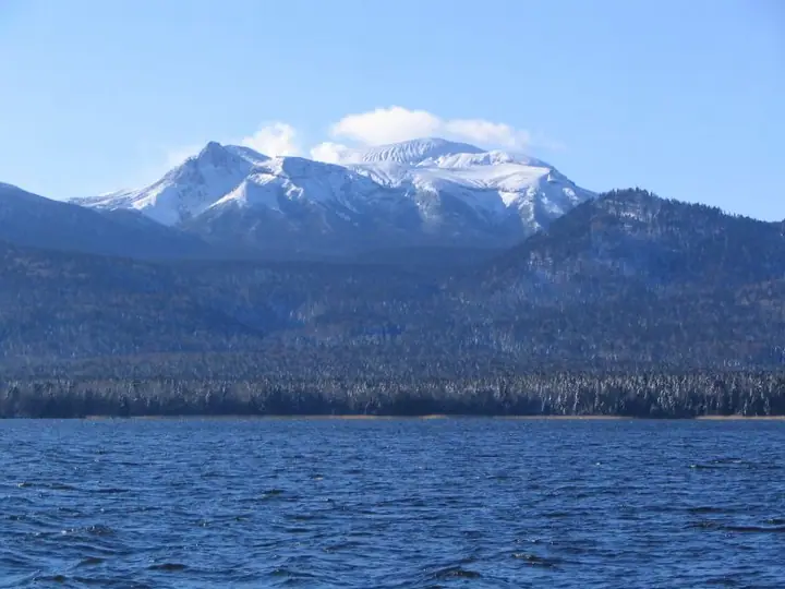
A 1,328 m peak on the crater rim of the active volcano Mount Meakan, in Akan-Mashu National Park. Mount Meakan is a stratovolcano complex straddling Kushiro and Ashoro, and from near Kengamine one looks over Lake Akan and Mount Oakan; trails climb from Meakan Onsen and Lake Onneto. The Akankohan Trail passes through an alpine flower meadow near the peak.
Kengamine at a glance
- Weather: The most settled day in the next 7 days is Mon, November 9: clear, gusts up to 8 m/s. Sat, Nov 7, Sun, Nov 8: strong wind (gusts up to 21 m/s).
Kengamine weather (hourly, 14 days)
Sunrise today 06:01, sunset 16:14
| Tue, 11/3 | Wed, 11/4 | Thu, 11/5 | Fri, 11/6 | Sat, 11/7 | Sun, 11/8 | Mon, 11/9 | Tue, 11/10 | Wed, 11/11 | Thu, 11/12 | Fri, 11/13 | Sat, 11/14 | Sun, 11/15 | Mon, 11/16 | Tue, 11/17 | |||||||||||||||||||||||||||||||||||||||||||||||||||||||||||||||||||||||
|---|---|---|---|---|---|---|---|---|---|---|---|---|---|---|---|---|---|---|---|---|---|---|---|---|---|---|---|---|---|---|---|---|---|---|---|---|---|---|---|---|---|---|---|---|---|---|---|---|---|---|---|---|---|---|---|---|---|---|---|---|---|---|---|---|---|---|---|---|---|---|---|---|---|---|---|---|---|---|---|---|---|---|---|---|---|
| Japan time | 15 | 17 | 19 | 21 | 23 | 1 | 3 | 5 | 7 | 9 | 11 | 13 | 15 | 18 | 21 | 0 | 3 | 6 | 9 | 12 | 15 | 18 | 21 | 0 | 3 | 6 | 9 | 12 | 15 | 18 | 21 | 0 | 3 | 6 | 9 | 12 | 15 | 18 | 21 | 0 | 3 | 6 | 9 | 12 | 15 | 18 | 21 | 0 | 3 | 6 | 9 | 15 | 21 | 3 | 9 | 15 | 21 | 3 | 9 | 15 | 21 | 3 | 9 | 15 | 21 | 3 | 9 | 15 | 21 | 3 | 9 | 15 | 21 | 3 | 9 | 15 | 21 | 3 | 9 | 15 | 21 | 3 | 9 | 15 | |
  |  | | | |   |   | | | | | |  |  | | | | | |   |   |   |   | | | | | | | |   | | | | | |   |   | | | | | | | | | |   | | | | | | | | | | |   | | | | | | |   |   | | |  | | | | | | | |   | | | | | | | ||
| Temperature | °C | 0° | -5° | -7° | -8° | -8° | -7° | -6° | -7° | -5° | -1° | 1° | 1° | 1° | -5° | -6° | -4° | -3° | -4° | 3° | 5° | 3° | 3° | 2° | 3° | 3° | 3° | 3° | 3° | 4° | 4° | 0° | -2° | -5° | -7° | -5° | -3° | -5° | -7° | -7° | -7° | -7° | -8° | -5° | -4° | -4° | -6° | -9° | -8° | -9° | -9° | -4° | -3° | -9° | -9° | -5° | -5° | -7° | -7° | -5° | -3° | -7° | -6° | -3° | -2° | -8° | -7° | -7° | -5° | -8° | -8° | -5° | -3° | -6° | -6° | 0° | 1° | -2° | -1° | -1° | -4° | -6° | -8° | -5° | -3° |
| Precipitation | mm | 0.1 | 0.3 | 1.2 | 4.8 | 1.7 | 2.7 | 1.2 | 3.9 | 0.4 | 0.4 | 0.3 | 0.9 | 0.3 | 0.2 | 0.2 | 0.3 | 0.4 | 0.9 | 1.0 | 0.4 | ||||||||||||||||||||||||||||||||||||||||||||||||||||||||||||||||
| New snow | cm | <.1 | 0.1 | <.1 | 0.3 | 0.9 | <.1 | 0.3 | 0.2 | 0.2 | 0.8 | 0.9 | 0.4 | ||||||||||||||||||||||||||||||||||||||||||||||||||||||||||||||||||||||||
| Snow depth | cm | <1 | <1 | <1 | <1 | <1 | <1 | <1 | <1 | <1 | <1 | <1 | <1 | <1 | <1 | <1 | <1 | <1 | <1 | <1 | <1 | 0 | 0 | 0 | 0 | 0 | 0 | 0 | 0 | 0 | 0 | 0 | 0 | 0 | 0 | 0 | 0 | 0 | 0 | 0 | 0 | 0 | 0 | 0 | 0 | 0 | 0 | 0 | 0 | 0 | 0 | 0 | 0 | 0 | 0 | 0 | 0 | 0 | 0 | <1 | <1 | <1 | <1 | <1 | <1 | <1 | <1 | <1 | <1 | <1 | <1 | <1 | <1 | <1 | <1 | <1 | <1 | <1 | 0 | 0 | <1 | 1 | 1 | 1 | 1 |
| Wind | m/s | 4 | 2 | 2 | 1 | 0 | 1 | 2 | 2 | 3 | 4 | 3 | 2 | 1 | 2 | 2 | 2 | 2 | 2 | 3 | 4 | 2 | 2 | 1 | 1 | 1 | 2 | 3 | 2 | 2 | 2 | 6 | 7 | 6 | 5 | 7 | 8 | 7 | 6 | 6 | 7 | 7 | 6 | 6 | 7 | 7 | 4 | 1 | 1 | 2 | 1 | 1 | 0 | 1 | 0 | 1 | 2 | 2 | 2 | 2 | 2 | 1 | 1 | 0 | 4 | 1 | 3 | 4 | 5 | 7 | 6 | 5 | 2 | 1 | 1 | 2 | 2 | 3 | 2 | 2 | 6 | 6 | 5 | 5 | 1 |
| Wind gusts | m/s | 12 | 10 | 6 | 5 | 3 | 5 | 8 | 9 | 10 | 12 | 11 | 9 | 6 | 5 | 8 | 7 | 6 | 7 | 10 | 11 | 11 | 6 | 5 | 4 | 5 | 5 | 7 | 8 | 7 | 7 | 16 | 17 | 17 | 15 | 18 | 21 | 21 | 19 | 17 | 17 | 18 | 18 | 17 | 18 | 19 | 17 | 10 | 5 | 5 | 5 | 5 | 8 | 3 | 3 | 4 | 5 | 5 | 5 | 6 | 7 | 4 | 3 | 4 | 10 | 9 | 7 | 10 | 15 | 20 | 19 | 16 | 14 | 5 | 4 | 7 | 11 | 8 | 8 | 6 | 15 | 16 | 16 | 13 | 12 |
| Wind dir. | ↓ | ↓ | ↓ | ↓ | ↓ | ↓ | ↓ | ↓ | ↓ | ↓ | ↓ | ↓ | ↓ | ↓ | ↓ | ↓ | ↓ | ↓ | ↓ | ↓ | ↓ | ↓ | ↓ | ↓ | ↓ | ↓ | ↓ | ↓ | ↓ | ↓ | ↓ | ↓ | ↓ | ↓ | ↓ | ↓ | ↓ | ↓ | ↓ | ↓ | ↓ | ↓ | ↓ | ↓ | ↓ | ↓ | ↓ | ↓ | ↓ | ↓ | ↓ | ↓ | ↓ | ↓ | ↓ | ↓ | ↓ | ↓ | ↓ | ↓ | ↓ | ↓ | ↓ | ↓ | ↓ | ↓ | ↓ | ↓ | ↓ | ↓ | ↓ | ↓ | ↓ | ↓ | ↓ | ↓ | ↓ | ↓ | ↓ | ↓ | ↓ | ↓ | ↓ | ↓ | |
Huts, campsites and lodging near Kengamine
Campsites
- オンネトー国設野営場
Lodging
- 山の宿 野中温泉
Kengamine facts
- Elevation
- 1,328 m
- Location
- Ashoro, Hokkaido
43.391967, 144.027076 - National Park
- 阿寒摩周国立公園
- Volcano
- Active volcano (雌阿寒岳)
- Website
- www.town.ashoro.hokkaido.jp
- Trail Map
- www.env.go.jp
- Wikipedia
- ja.wikipedia.org