
Mount Aizu-Komagatake
会津駒ヶ岳
Hinoemata, Fukushima · Elevation 2,133 m
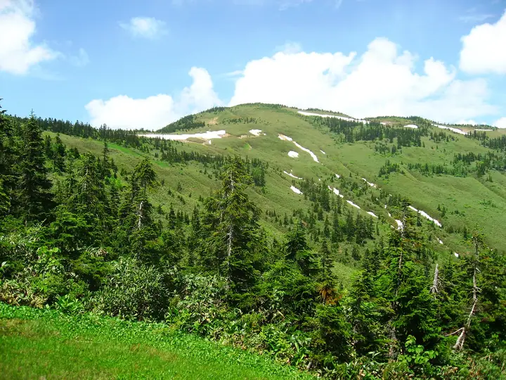
Mount Aizu-Komagatake (2,133 m) stands in Hinoemata Village, Fukushima Prefecture, on the northeastern edge of Oze National Park within the Echigo Mountains. Its broad summit ridge holds an expansive alpine wetland dotted with ponds and seasonal flowers such as Hakusan-kozakura, earning it the nickname "paradise in the sky." It is listed among the 100 Famous Mountains of Japan, the 100 First-Order Triangulation Mountains, and the New 100 Mountains of Flowers.
Mount Aizu-Komagatake at a glance
- Weather: The most settled day in the next 7 days is Wed, November 4: clear, gusts up to 5 m/s. Fri, Nov 6, Sat, Nov 7, Sun, Nov 8: strong wind (gusts up to 21 m/s). Sat, Nov 7: heavy snow (13 cm of new snow during the day).
- Route: The shortest is Mount Aizu-Komagatake and Mount Chumon Return from Takizawa Trailhead: about 8 h 8 min, 13.0 km, about 1,180 m of climbing.
Mount Aizu-Komagatake weather (hourly, 14 days)
Sunrise today 06:08, sunset 16:45
| Tue, 11/3 | Wed, 11/4 | Thu, 11/5 | Fri, 11/6 | Sat, 11/7 | Sun, 11/8 | Mon, 11/9 | Tue, 11/10 | Wed, 11/11 | Thu, 11/12 | Fri, 11/13 | Sat, 11/14 | Sun, 11/15 | Mon, 11/16 | Tue, 11/17 | |||||||||||||||||||||||||||||||||||||||||||||||||||||||||||||||||||||||
|---|---|---|---|---|---|---|---|---|---|---|---|---|---|---|---|---|---|---|---|---|---|---|---|---|---|---|---|---|---|---|---|---|---|---|---|---|---|---|---|---|---|---|---|---|---|---|---|---|---|---|---|---|---|---|---|---|---|---|---|---|---|---|---|---|---|---|---|---|---|---|---|---|---|---|---|---|---|---|---|---|---|---|---|---|---|
| Japan time | 15 | 17 | 19 | 21 | 23 | 1 | 3 | 5 | 7 | 9 | 11 | 13 | 15 | 18 | 21 | 0 | 3 | 6 | 9 | 12 | 15 | 18 | 21 | 0 | 3 | 6 | 9 | 12 | 15 | 18 | 21 | 0 | 3 | 6 | 9 | 12 | 15 | 18 | 21 | 0 | 3 | 6 | 9 | 12 | 15 | 18 | 21 | 0 | 3 | 6 | 9 | 15 | 21 | 3 | 9 | 15 | 21 | 3 | 9 | 15 | 21 | 3 | 9 | 15 | 21 | 3 | 9 | 15 | 21 | 3 | 9 | 15 | 21 | 3 | 9 | 15 | 21 | 3 | 9 | 15 | 21 | 3 | 9 | 15 | |
  |   |   |   |  | | | |  | | | |   | | |   | | | |   |   | | | | | | | | | | |   | |   |   | | | | | | | |   | | | | |   | | | |   | | | | | | | | | | | | | | | | | | | | |  | | | | |   | | | | | | | ||
| Temperature | °C | 0° | -2° | -5° | -6° | -6° | -6° | -6° | -5° | -4° | 3° | 5° | 7° | 6° | 1° | 2° | 2° | 2° | 2° | 5° | 8° | 8° | 4° | 3° | 3° | 2° | 3° | 4° | 5° | 5° | 2° | 0° | -2° | -3° | -4° | -4° | -5° | -5° | -6° | -6° | -6° | -6° | -6° | -5° | -3° | -4° | -6° | -6° | -6° | -5° | -6° | 0° | -2° | -5° | -7° | 0° | 1° | -3° | -5° | -5° | -4° | -5° | -5° | -3° | -2° | -8° | -4° | -4° | -5° | -7° | -9° | -2° | 2° | -9° | -8° | 4° | 4° | -1° | 1° | 4° | 0° | -5° | -7° | -4° | -1° |
| Precipitation | mm | 0.2 | 0.1 | 8 | 8 | 1.0 | 1.8 | 0.2 | 1.4 | 1.4 | 0.7 | 1.8 | 2.0 | 2.5 | 2.3 | 3.3 | 4.2 | 4.7 | 4.0 | 2.7 | 1.4 | 0.7 | 0.3 | 0.3 | 0.7 | 0.3 | 0.2 | 0.4 | 0.3 | 0.1 | 3.2 | 5 | 4.3 | 2.7 | 0.6 | 11 | 1.5 | 0.7 | 3.2 | 6 | 0.1 | 7 | 7 | 0.7 | |||||||||||||||||||||||||||||||||||||||||
| New snow | cm | <.1 | 0.6 | 2.9 | 4.2 | 4.7 | 4.0 | 2.7 | 1.4 | 0.7 | 0.3 | 0.3 | 0.5 | 0.2 | 0.2 | <.1 | 0.4 | 0.3 | <.1 | 2.9 | 5.1 | 4.2 | 2.4 | 0.4 | <.1 | <.1 | 10 | 1.4 | 0.5 | 2.2 | 0.5 | ||||||||||||||||||||||||||||||||||||||||||||||||||||||
| Snow depth | cm | 0 | 0 | 0 | 0 | 0 | 0 | 0 | 0 | 0 | 0 | 0 | 0 | 0 | 0 | 0 | 0 | 0 | 0 | 0 | 0 | 0 | 0 | 0 | 0 | 0 | 0 | 0 | 0 | 0 | 0 | 0 | 0 | <1 | 2 | 5 | 7 | 10 | 11 | 12 | 12 | 12 | 12 | 12 | 11 | 11 | 11 | 11 | 11 | 11 | 11 | 11 | 8 | 8 | 7 | 7 | 5 | 4 | 6 | 9 | 11 | 12 | 12 | 12 | 10 | 10 | 10 | 17 | 17 | 17 | 17 | 16 | 14 | 14 | 14 | 14 | 10 | 9 | 7 | 6 | 3 | 3 | 4 | 4 | 3 |
| Wind | m/s | 4 | 2 | 2 | 2 | 1 | 1 | 1 | 1 | 1 | 1 | 1 | 1 | 1 | 3 | 3 | 3 | 2 | 3 | 1 | 0 | 0 | 1 | 1 | 1 | 1 | 2 | 4 | 5 | 5 | 4 | 4 | 4 | 4 | 5 | 4 | 5 | 6 | 5 | 5 | 5 | 5 | 3 | 4 | 4 | 3 | 2 | 1 | 1 | 1 | 1 | 1 | 1 | 1 | 2 | 1 | 2 | 1 | 4 | 6 | 6 | 4 | 2 | 2 | 2 | 2 | 3 | 3 | 6 | 3 | 1 | 1 | 1 | 1 | 1 | 0 | 1 | 2 | 3 | 1 | 4 | 6 | 2 | 1 | 1 |
| Wind gusts | m/s | 13 | 12 | 8 | 8 | 7 | 6 | 5 | 5 | 5 | 4 | 5 | 5 | 5 | 9 | 13 | 14 | 12 | 10 | 11 | 7 | 5 | 4 | 5 | 5 | 6 | 8 | 15 | 18 | 17 | 15 | 18 | 16 | 19 | 19 | 18 | 21 | 21 | 20 | 20 | 19 | 20 | 18 | 15 | 15 | 15 | 11 | 7 | 7 | 6 | 6 | 6 | 6 | 5 | 5 | 6 | 10 | 11 | 12 | 24 | 25 | 19 | 12 | 8 | 8 | 8 | 10 | 12 | 18 | 18 | 11 | 6 | 6 | 6 | 5 | 5 | 6 | 9 | 13 | 12 | 20 | 20 | 19 | 9 | 6 |
| Wind dir. | ↓ | ↓ | ↓ | ↓ | ↓ | ↓ | ↓ | ↓ | ↓ | ↓ | ↓ | ↓ | ↓ | ↓ | ↓ | ↓ | ↓ | ↓ | ↓ | ↓ | ↓ | ↓ | ↓ | ↓ | ↓ | ↓ | ↓ | ↓ | ↓ | ↓ | ↓ | ↓ | ↓ | ↓ | ↓ | ↓ | ↓ | ↓ | ↓ | ↓ | ↓ | ↓ | ↓ | ↓ | ↓ | ↓ | ↓ | ↓ | ↓ | ↓ | ↓ | ↓ | ↓ | ↓ | ↓ | ↓ | ↓ | ↓ | ↓ | ↓ | ↓ | ↓ | ↓ | ↓ | ↓ | ↓ | ↓ | ↓ | ↓ | ↓ | ↓ | ↓ | ↓ | ↓ | ↓ | ↓ | ↓ | ↓ | ↓ | ↓ | ↓ | ↓ | ↓ | ↓ | |
Mount Aizu-Komagatake hiking routes
Hiking times are estimates calculated from the terrain.
Huts, campsites and lodging near Mount Aizu-Komagatake
Mountain huts
Campsites
- 見通りオートキャンプ場
- 泉キャンプ場
Lodging
- あづま
- 民宿松源
- 檜扇
- 民宿わたすげ荘
- ひのき屋
Lists that include Mount Aizu-Komagatake
100 Famous Japanese Mountains · Japan 200 Famous Mountains · Japan's 300 Famous Mountains · New 100 Famous Flower Mountains · 100 Famous Mountains with First-order Triangulation Points · Tohoku 100 Famous Mountains · Utsukushima 100 Famous Mountains (Fukushima Prefecture) · Aizu 100 Famous Mountains · 30 Peaks of Fukushima · Elevations of 1003 Mountains of Japan · 1000 Mountains of Japan
Mount Aizu-Komagatake facts
- Elevation
- 2,133 m
- Location
- Hinoemata, Fukushima
37.047591, 139.353751 - National Park
- 尾瀬国立公園
- Website
- oze-fnd.or.jp
- Trail Map
- wwwcms.pref.fukushima.jp
- Wikipedia
- ja.wikipedia.org