
Mount Aizu-Asahi
会津朝日岳
Tadami, Fukushima · Elevation 1,624 m
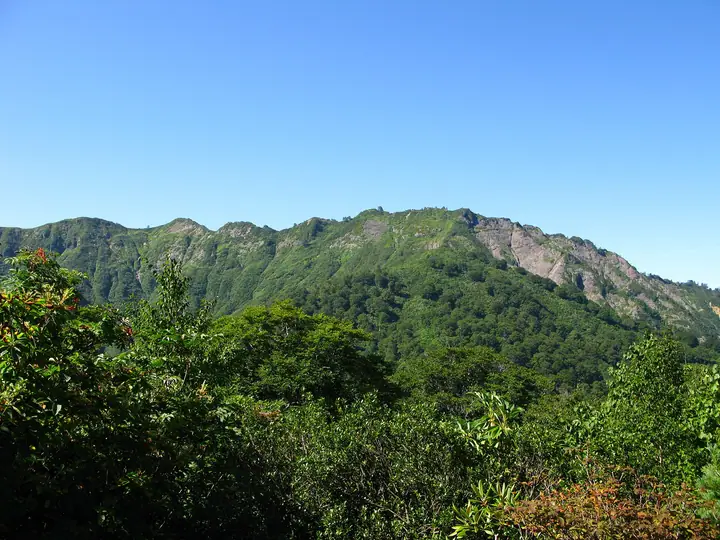
Mount Aizu-Asahi is a 1,624.2 m peak in Tadami Town, southern Aizu, Fukushima Prefecture, lying at the northern end of the Koma-Asahi range and within the Echigo-Sanzan Tadami Quasi-National Park. It is included in the Nihon Nihyaku Meizan, Tōhoku Hyakumeizan, Utsukushima Hyakumeizan, Aizu Hyakumeizan, and the "Tadami Four Mountains." The name reflects a distinctive feature noted in the Edo-period Shin-Pen Aizu Fudoki: while the deep valleys around it remain shaded, the summit catches the morning sun unusually early. A single trail climbs from the Akakura-sawa trailhead via the Mishichi-michigi spring, Hitomi-no-matsu, and Kanō-no-takate, taking about four hours one way. After the 2011 Niigata-Fukushima floods damaged the route, the trail was closed for four years and reopened in 2015; Tadami Town hosts the official yamabiraki (mountain opening) on the second Sunday of June each year, and the peak is celebrated for its rhododendron groves, beech forest, and October foliage.
Mount Aizu-Asahi at a glance
- Weather: The most settled day in the next 7 days is Wed, November 4: clear, gusts up to 8 m/s. Fri, Nov 6, Sat, Nov 7: strong wind (gusts up to 19 m/s).
- Route: The shortest is Mount Aizu-Asahi via the Akakurasawa Trail: about 7 h 8 min, 11.3 km, about 1,300 m of climbing.
Mount Aizu-Asahi weather (hourly, 14 days)
Sunrise today 06:08, sunset 16:44
| Tue, 11/3 | Wed, 11/4 | Thu, 11/5 | Fri, 11/6 | Sat, 11/7 | Sun, 11/8 | Mon, 11/9 | Tue, 11/10 | Wed, 11/11 | Thu, 11/12 | Fri, 11/13 | Sat, 11/14 | Sun, 11/15 | Mon, 11/16 | Tue, 11/17 | |||||||||||||||||||||||||||||||||||||||||||||||||||||||||||||||||||||||
|---|---|---|---|---|---|---|---|---|---|---|---|---|---|---|---|---|---|---|---|---|---|---|---|---|---|---|---|---|---|---|---|---|---|---|---|---|---|---|---|---|---|---|---|---|---|---|---|---|---|---|---|---|---|---|---|---|---|---|---|---|---|---|---|---|---|---|---|---|---|---|---|---|---|---|---|---|---|---|---|---|---|---|---|---|---|
| Japan time | 15 | 17 | 19 | 21 | 23 | 1 | 3 | 5 | 7 | 9 | 11 | 13 | 15 | 18 | 21 | 0 | 3 | 6 | 9 | 12 | 15 | 18 | 21 | 0 | 3 | 6 | 9 | 12 | 15 | 18 | 21 | 0 | 3 | 6 | 9 | 12 | 15 | 18 | 21 | 0 | 3 | 6 | 9 | 12 | 15 | 18 | 21 | 0 | 3 | 6 | 9 | 15 | 21 | 3 | 9 | 15 | 21 | 3 | 9 | 15 | 21 | 3 | 9 | 15 | 21 | 3 | 9 | 15 | 21 | 3 | 9 | 15 | 21 | 3 | 9 | 15 | 21 | 3 | 9 | 15 | 21 | 3 | 9 | 15 | |
  |   |  | |   | | | | |  | | | | |   | | | |   |   |   | |   | | | | | | | | | | |   |   | | | | | | | | | | | | | | | |   |   | | | | | | |   | | | | | |   | | | | | | | |  | | | | | | | | | | | | ||
| Temperature | °C | 4° | 0° | -2° | -3° | -5° | -5° | -5° | -4° | -2° | 4° | 6° | 8° | 8° | 2° | 2° | 1° | 2° | 3° | 5° | 6° | 8° | 5° | 6° | 5° | 3° | 5° | 6° | 6° | 7° | 4° | 2° | 0° | -1° | -2° | -3° | -2° | -3° | -4° | -4° | -4° | -4° | -4° | -2° | 0° | -1° | -2° | -2° | -3° | -3° | -3° | 0° | 1° | -2° | -5° | 1° | 7° | 0° | -4° | -2° | -1° | -2° | -2° | 0° | 0° | -5° | -1° | -2° | -1° | -3° | -5° | 0° | 5° | -6° | -6° | 5° | 7° | 2° | 2° | 5° | 2° | -3° | -4° | -2° | 1° |
| Precipitation | mm | 1.2 | 1.8 | 7 | 8 | 1.1 | 2.5 | 1.1 | 2.3 | 2.6 | 0.8 | 3.5 | 4.6 | 3.1 | 3.9 | 5 | 6 | 6 | 3.2 | 1.9 | 1.4 | 0.4 | 0.8 | 1.0 | 0.5 | 0.5 | 0.2 | 0.2 | 0.1 | 0.8 | 0.6 | 0.1 | 6 | 4.3 | 3.3 | 1.5 | 0.4 | 0.1 | 0.4 | 0.2 | 0.9 | 11 | 0.4 | 4.2 | 7 | 1.2 | 6 | 4.3 | 0.7 | ||||||||||||||||||||||||||||||||||||
| New snow | cm | 0.2 | 2.7 | 3.0 | 1.3 | 0.5 | 0.4 | 0.2 | 0.2 | <.1 | 2.8 | 3.8 | <.1 | 0.1 | |||||||||||||||||||||||||||||||||||||||||||||||||||||||||||||||||||||||
| Snow depth | cm | 0 | 0 | 0 | 0 | 0 | 0 | 0 | 0 | 0 | 0 | 0 | 0 | 0 | 0 | 0 | 0 | 0 | 0 | 0 | 0 | 0 | 0 | 0 | 0 | 0 | 0 | 0 | 0 | 0 | 0 | 0 | 0 | 0 | 0 | 1 | 2 | 2 | 2 | 2 | 2 | 2 | 2 | 1 | 1 | <1 | <1 | <1 | 0 | 0 | 0 | 0 | 0 | 0 | 0 | 0 | 0 | 0 | 2 | 3 | <1 | <1 | 0 | 0 | 0 | 0 | 0 | 0 | 0 | 0 | 0 | 0 | 0 | 0 | 0 | 0 | 0 | 0 | 0 | 0 | 0 | 0 | 0 | 0 | 0 |
| Wind | m/s | 4 | 2 | 1 | 1 | 2 | 2 | 1 | 1 | 1 | 0 | 2 | 2 | 3 | 2 | 1 | 1 | 1 | 1 | 0 | 1 | 1 | 1 | 2 | 1 | 1 | 2 | 5 | 5 | 6 | 5 | 4 | 4 | 5 | 5 | 4 | 5 | 6 | 5 | 5 | 6 | 5 | 5 | 5 | 5 | 4 | 2 | 2 | 1 | 1 | 1 | 0 | 3 | 1 | 1 | 2 | 2 | 1 | 4 | 6 | 5 | 3 | 2 | 4 | 4 | 2 | 4 | 3 | 5 | 2 | 2 | 1 | 2 | 1 | 1 | 1 | 1 | 1 | 1 | 2 | 5 | 5 | 3 | 1 | 2 |
| Wind gusts | m/s | 11 | 9 | 6 | 5 | 5 | 5 | 5 | 4 | 4 | 3 | 6 | 7 | 8 | 8 | 6 | 7 | 4 | 6 | 6 | 3 | 4 | 3 | 5 | 6 | 4 | 6 | 14 | 15 | 16 | 16 | 14 | 13 | 15 | 18 | 14 | 17 | 19 | 16 | 16 | 16 | 15 | 14 | 13 | 13 | 14 | 10 | 6 | 5 | 4 | 3 | 3 | 8 | 7 | 3 | 5 | 7 | 9 | 13 | 18 | 20 | 15 | 9 | 9 | 11 | 9 | 12 | 13 | 14 | 13 | 7 | 5 | 7 | 6 | 4 | 4 | 6 | 5 | 5 | 7 | 17 | 16 | 14 | 8 | 6 |
| Wind dir. | ↓ | ↓ | ↓ | ↓ | ↓ | ↓ | ↓ | ↓ | ↓ | ↓ | ↓ | ↓ | ↓ | ↓ | ↓ | ↓ | ↓ | ↓ | ↓ | ↓ | ↓ | ↓ | ↓ | ↓ | ↓ | ↓ | ↓ | ↓ | ↓ | ↓ | ↓ | ↓ | ↓ | ↓ | ↓ | ↓ | ↓ | ↓ | ↓ | ↓ | ↓ | ↓ | ↓ | ↓ | ↓ | ↓ | ↓ | ↓ | ↓ | ↓ | ↓ | ↓ | ↓ | ↓ | ↓ | ↓ | ↓ | ↓ | ↓ | ↓ | ↓ | ↓ | ↓ | ↓ | ↓ | ↓ | ↓ | ↓ | ↓ | ↓ | ↓ | ↓ | ↓ | ↓ | ↓ | ↓ | ↓ | ↓ | ↓ | ↓ | ↓ | ↓ | ↓ | ↓ | |
Mount Aizu-Asahi hiking routes
Hiking times are estimates calculated from the terrain.
Huts, campsites and lodging near Mount Aizu-Asahi
Mountain huts
Lists that include Mount Aizu-Asahi
Japan 200 Famous Mountains · Japan's 300 Famous Mountains · Tohoku 100 Famous Mountains · Utsukushima 100 Famous Mountains (Fukushima Prefecture) · Aizu 100 Famous Mountains · Elevations of 1003 Mountains of Japan · 1000 Mountains of Japan
Mount Aizu-Asahi facts
- Also known as
- 朝日岳
- Elevation
- 1,624 m
- Location
- Tadami, Fukushima
37.221175, 139.339669 - National Park
- 越後三山只見国定公園
- Website
- www.tadami-net.com
- Trail Map
- www.town.tadami.lg.jp (PDF)
- Wikipedia
- ja.wikipedia.org