
Hokkaido Koma-ga-take
駒ヶ岳
北海道駒ヶ岳 レベル2(火口周辺規制) · issued October 2 at 07:30
Mori, Hokkaido / Shikabe, Hokkaido · Elevation 1,131 m
Hokkaido Koma-ga-take is a 1,131 m active stratovolcano in the southern Oshima Peninsula and a centerpiece of Onuma Quasi-National Park. Also called Oshima Fuji, its former cone lost its summit through eruptions and collapse; Kengamine, Sawaradake and Sumitamori surround the crater floor. Crater-area access has been restricted since 1998. Restrictions are normally eased from June 1 to October 31 along the Akaigawa trail to Umanose, around 900 m. However, the trail gate closed when the volcanic alert level rose to 2 on October 2, 2026.
Hokkaido Koma-ga-take at a glance
- Weather: The most settled day in the next 7 days is Thu, November 5: cloudy, gusts up to 5 m/s. Fri, Nov 6, Sat, Nov 7, Sun, Nov 8: strong wind (gusts up to 22 m/s).
Hokkaido Koma-ga-take weather (hourly, 14 days)
Sunrise today 06:11, sunset 16:30
| Tue, 11/3 | Wed, 11/4 | Thu, 11/5 | Fri, 11/6 | Sat, 11/7 | Sun, 11/8 | Mon, 11/9 | Tue, 11/10 | Wed, 11/11 | Thu, 11/12 | Fri, 11/13 | Sat, 11/14 | Sun, 11/15 | Mon, 11/16 | Tue, 11/17 | ||||||||||||||||||||||||||||||||||||||||||||||||||||||||||||||||||||||
|---|---|---|---|---|---|---|---|---|---|---|---|---|---|---|---|---|---|---|---|---|---|---|---|---|---|---|---|---|---|---|---|---|---|---|---|---|---|---|---|---|---|---|---|---|---|---|---|---|---|---|---|---|---|---|---|---|---|---|---|---|---|---|---|---|---|---|---|---|---|---|---|---|---|---|---|---|---|---|---|---|---|---|---|---|
| Japan time | 21 | 23 | 1 | 3 | 5 | 7 | 9 | 11 | 13 | 15 | 17 | 19 | 21 | 0 | 3 | 6 | 9 | 12 | 15 | 18 | 21 | 0 | 3 | 6 | 9 | 12 | 15 | 18 | 21 | 0 | 3 | 6 | 9 | 12 | 15 | 18 | 21 | 0 | 3 | 6 | 9 | 12 | 15 | 18 | 21 | 0 | 3 | 6 | 9 | 15 | 21 | 3 | 9 | 15 | 21 | 3 | 9 | 15 | 21 | 3 | 9 | 15 | 21 | 3 | 9 | 15 | 21 | 3 | 9 | 15 | 21 | 3 | 9 | 15 | 21 | 3 | 9 | 15 | 21 | 3 | 9 | 15 | 21 | |
  |   |   |   |  |  | | | | |  | | | | | |   |   |   |   |   | | | | | |   | | |   |   | |   |   |   | | | | | | | | | | | |   | | | | | | | |   | |   | | | |   | | | | | | |  | | | | |   | | | | | | |  | | | | ||
| Temperature | °C | -2° | -2° | -1° | 0° | -1° | -1° | 1° | 3° | 4° | 3° | -1° | -3° | -3° | -3° | -3° | -2° | 4° | 7° | 7° | 3° | 4° | 5° | 5° | 4° | 7° | 8° | 5° | 1° | -2° | -4° | -5° | -6° | -4° | -4° | -4° | -5° | -5° | -5° | -5° | -6° | -4° | -2° | -4° | -5° | -5° | -5° | -5° | -6° | -4° | -3° | -7° | -7° | -3° | -3° | -4° | -4° | -4° | -1° | -5° | -7° | -2° | -2° | -6° | -5° | -5° | -4° | -5° | -7° | -2° | 0° | -6° | -1° | 2° | 5° | 2° | 0° | -1° | -2° | -6° | -6° | -2° | -1° | -6° |
| Precipitation | mm | 0.2 | 1.5 | 1.0 | 1.2 | 2.7 | 2.5 | 2.2 | 1.1 | 0.3 | 0.3 | 0.5 | 0.4 | 0.8 | 0.7 | 0.9 | 0.6 | 0.4 | 0.2 | 0.2 | 0.1 | 0.2 | 4.8 | 2.6 | 0.5 | 0.8 | 0.1 | 0.3 | 0.5 | 0.6 | 0.9 | 3.5 | 2.3 | 1.8 | ||||||||||||||||||||||||||||||||||||||||||||||||||
| New snow | cm | 0.4 | <.1 | – | – | 0.2 | 0.4 | 0.5 | 0.6 | 0.7 | 0.5 | 0.5 | 0.4 | 0.2 | 0.1 | <.1 | <.1 | <.1 | <.1 | <.1 | 0.2 | 4.1 | 2.0 | <.1 | 0.2 | <.1 | <.1 | 0.3 | <.1 | |||||||||||||||||||||||||||||||||||||||||||||||||||||||
| Snow depth | cm | 0 | 0 | 0 | 0 | 0 | 0 | 0 | 0 | 0 | 0 | 0 | 0 | 0 | 0 | 0 | 0 | 0 | 0 | 0 | 0 | 0 | 0 | 0 | 0 | 0 | 0 | 0 | 0 | 0 | 0 | <1 | <1 | <1 | 1 | 1 | 1 | 1 | 1 | 1 | 1 | 1 | 1 | <1 | <1 | <1 | <1 | <1 | <1 | <1 | <1 | <1 | <1 | <1 | <1 | <1 | 3 | 3 | 2 | 2 | 2 | 2 | 1 | 1 | 1 | 1 | 1 | 1 | 1 | 1 | 1 | 1 | <1 | <1 | <1 | <1 | 0 | 0 | 0 | 0 | 0 | 0 | 0 | 0 |
| Wind | m/s | 3 | 3 | 5 | 4 | 4 | 4 | 4 | 2 | 1 | 2 | 1 | 2 | 2 | 2 | 2 | 1 | 0 | 1 | 2 | 1 | 1 | 1 | 0 | 2 | 3 | 5 | 7 | 6 | 7 | 7 | 7 | 6 | 7 | 8 | 7 | 8 | 7 | 7 | 7 | 6 | 8 | 8 | 7 | 5 | 4 | 3 | 3 | 2 | 5 | 4 | 2 | 2 | 0 | 3 | 5 | 5 | 3 | 3 | 1 | 1 | 2 | 3 | 2 | 3 | 5 | 5 | 3 | 1 | 1 | 3 | 2 | 2 | 3 | 3 | 3 | 2 | 5 | 6 | 5 | 3 | 3 | 4 | 1 |
| Wind gusts | m/s | 10 | 11 | 15 | 16 | 13 | 12 | 12 | 12 | 8 | 6 | 7 | 5 | 7 | 6 | 7 | 6 | 4 | 5 | 5 | 5 | 6 | 9 | 5 | 6 | 9 | 14 | 20 | 20 | 20 | 21 | 22 | 22 | 20 | 22 | 22 | 22 | 21 | 18 | 19 | 19 | 21 | 22 | 22 | 19 | 14 | 12 | 9 | 9 | 13 | 13 | 11 | 7 | 6 | 9 | 14 | 14 | 13 | 10 | 9 | 5 | 8 | 13 | 9 | 9 | 14 | 14 | 12 | 8 | 4 | 9 | 8 | 8 | 10 | 10 | 9 | 10 | 12 | 18 | 16 | 13 | 10 | 10 | 9 |
| Wind dir. | ↓ | ↓ | ↓ | ↓ | ↓ | ↓ | ↓ | ↓ | ↓ | ↓ | ↓ | ↓ | ↓ | ↓ | ↓ | ↓ | ↓ | ↓ | ↓ | ↓ | ↓ | ↓ | ↓ | ↓ | ↓ | ↓ | ↓ | ↓ | ↓ | ↓ | ↓ | ↓ | ↓ | ↓ | ↓ | ↓ | ↓ | ↓ | ↓ | ↓ | ↓ | ↓ | ↓ | ↓ | ↓ | ↓ | ↓ | ↓ | ↓ | ↓ | ↓ | ↓ | ↓ | ↓ | ↓ | ↓ | ↓ | ↓ | ↓ | ↓ | ↓ | ↓ | ↓ | ↓ | ↓ | ↓ | ↓ | ↓ | ↓ | ↓ | ↓ | ↓ | ↓ | ↓ | ↓ | ↓ | ↓ | ↓ | ↓ | ↓ | ↓ | ↓ | ↓ | |
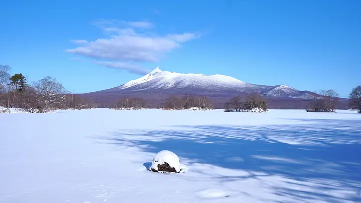
Hokkaido Koma-ga-take live cameras
Lists that include Hokkaido Koma-ga-take
Japan 200 Famous Mountains · Japan's 300 Famous Mountains · 100 Low Mountains of Japan · Illustrated Collection of Japan's Famous Mountains · 100 Fujis of Japan · Hokkaido 100 Famous Mountains · Elevations of 1003 Mountains of Japan · 1000 Mountains of Japan
Hokkaido Koma-ga-take facts
- Also known as
- 渡島富士 · 北海道駒ヶ岳
- Elevation
- 1,131 m
- Location
- Mori, Hokkaido / Shikabe, Hokkaido
42.063273, 140.677239 - National Park
- 大沼国定公園
- Volcano
- Active volcano (北海道駒ヶ岳)
- Season Opens
- June 1
- Season Closes
- October 31
- Website
- www.town.hokkaido-mori.lg.jp
- Trail Map
- www.town.hokkaido-mori.lg.jp (PDF)
- Wikipedia
- en.wikipedia.org