
Akita-Yakeyama
秋田焼山
Kazuno, Akita · Elevation 1,366 m
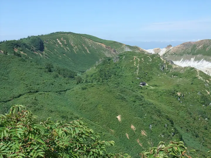
Akita-Yakeyama is a 1,366 m active volcano in Kazuno, Akita, within Towada-Hachimantai National Park. Its summit has a crater about 600 m across and lava domes, and repeated phreatic eruptions have occurred over recent centuries. Trails lead from Goshogake and Tamagawa hot springs, but high volcanic-gas concentrations around Sakebizawa and Yunosawa keep the Beko-yachi–Yakeyama shelter section closed. The route from Goshogake goes via Mosen Pass.
Akita-Yakeyama at a glance
- Weather: The most settled day in the next 7 days is Wed, November 4: clear, gusts up to 13 m/s. Fri, Nov 6, Sat, Nov 7, Sun, Nov 8: strong wind (gusts up to 24 m/s).
Akita-Yakeyama weather (hourly, 14 days)
Sunrise today 06:07, sunset 16:34
| Tue, 11/3 | Wed, 11/4 | Thu, 11/5 | Fri, 11/6 | Sat, 11/7 | Sun, 11/8 | Mon, 11/9 | Tue, 11/10 | Wed, 11/11 | Thu, 11/12 | Fri, 11/13 | Sat, 11/14 | Sun, 11/15 | Mon, 11/16 | Tue, 11/17 | |||||||||||||||||||||||||||||||||||||||||||||||||||||||||||||||||||||||
|---|---|---|---|---|---|---|---|---|---|---|---|---|---|---|---|---|---|---|---|---|---|---|---|---|---|---|---|---|---|---|---|---|---|---|---|---|---|---|---|---|---|---|---|---|---|---|---|---|---|---|---|---|---|---|---|---|---|---|---|---|---|---|---|---|---|---|---|---|---|---|---|---|---|---|---|---|---|---|---|---|---|---|---|---|---|
| Japan time | 15 | 17 | 19 | 21 | 23 | 1 | 3 | 5 | 7 | 9 | 11 | 13 | 15 | 18 | 21 | 0 | 3 | 6 | 9 | 12 | 15 | 18 | 21 | 0 | 3 | 6 | 9 | 12 | 15 | 18 | 21 | 0 | 3 | 6 | 9 | 12 | 15 | 18 | 21 | 0 | 3 | 6 | 9 | 12 | 15 | 18 | 21 | 0 | 3 | 6 | 9 | 15 | 21 | 3 | 9 | 15 | 21 | 3 | 9 | 15 | 21 | 3 | 9 | 15 | 21 | 3 | 9 | 15 | 21 | 3 | 9 | 15 | 21 | 3 | 9 | 15 | 21 | 3 | 9 | 15 | 21 | 3 | 9 | 15 | |
  |   | |   |  |   | | |   |  | | |   | | | | |   | |   | | | | | | | | | | |   | |   | |   | |   | | | | | | | | |   | | | |   | | | | | |   | | | | | | | | | | | | | | | | |  | | | | | | |   | | | | | ||
| Temperature | °C | 0° | -2° | -3° | -3° | -3° | -2° | -2° | -1° | 0° | 3° | 5° | 5° | 4° | -1° | -1° | -1° | 1° | 3° | 5° | 6° | 6° | 5° | 5° | 5° | 5° | 5° | 6° | 7° | 4° | 1° | -2° | -4° | -5° | -6° | -5° | -4° | -5° | -6° | -6° | -6° | -6° | -6° | -5° | -4° | -4° | -5° | -5° | -5° | -5° | -7° | -4° | -4° | -6° | -8° | -4° | -1° | -3° | -2° | -4° | -4° | -6° | -7° | -3° | -2° | -2° | -3° | -4° | -4° | -7° | -8° | -3° | -1° | -7° | -6° | 3° | 2° | 1° | 1° | 2° | -2° | -7° | -8° | -4° | -3° |
| Precipitation | mm | 0.1 | 0.1 | 3.4 | 3.7 | 1.3 | 1.8 | 0.5 | 4.1 | 1.5 | 0.5 | 0.6 | 3.3 | 3.8 | 1.4 | 3.2 | 1.7 | 1.6 | 1.9 | 2.3 | 2.2 | 2.7 | 2.3 | 0.9 | 1.1 | 0.8 | 0.7 | 0.3 | 0.2 | 0.1 | 0.8 | 0.4 | 2.0 | 6 | 9 | 2.5 | 0.2 | 0.6 | 0.4 | 5.0 | 0.1 | 1.6 | 2.7 | 1.2 | 5 | 4.5 | 0.1 | ||||||||||||||||||||||||||||||||||||||
| New snow | cm | <.1 | <.1 | 0.9 | 1.3 | 1.6 | 1.9 | 2.3 | 2.2 | 2.7 | 2.3 | 0.9 | 1.1 | 0.8 | 0.7 | 0.3 | 0.2 | <.1 | <.1 | 0.1 | 0.8 | 0.3 | <.1 | 2.0 | 4.2 | 8.2 | 2.4 | <.1 | 0.2 | 0.5 | 0.3 | 3.9 | <.1 | <.1 | <.1 | 1.6 | 4.3 | <.1 | <.1 | ||||||||||||||||||||||||||||||||||||||||||||||
| Snow depth | cm | <1 | <1 | <1 | <1 | <1 | <1 | <1 | <1 | <1 | <1 | 0 | 0 | 0 | 0 | 0 | 0 | 0 | 0 | 0 | 0 | 0 | 0 | 0 | 0 | 0 | 0 | 0 | 0 | 0 | 0 | <1 | 1 | 2 | 3 | 5 | 6 | 8 | 9 | 9 | 10 | 10 | 10 | 11 | 10 | 10 | 10 | 10 | 10 | 10 | 10 | 10 | 10 | 10 | 10 | 10 | 9 | 11 | 12 | 18 | 18 | 18 | 18 | 18 | 17 | 17 | 20 | 19 | 19 | 19 | 19 | 19 | 17 | 17 | 17 | 17 | 15 | 14 | 12 | 11 | 10 | 13 | 13 | 13 | 12 |
| Wind | m/s | 6 | 4 | 3 | 3 | 3 | 3 | 3 | 5 | 4 | 4 | 4 | 4 | 2 | 1 | 2 | 2 | 3 | 4 | 4 | 2 | 1 | 1 | 1 | 1 | 2 | 2 | 3 | 6 | 6 | 6 | 7 | 6 | 5 | 6 | 6 | 8 | 7 | 7 | 7 | 6 | 6 | 6 | 7 | 8 | 7 | 5 | 4 | 4 | 4 | 2 | 3 | 3 | 0 | 1 | 1 | 2 | 7 | 2 | 4 | 3 | 1 | 1 | 4 | 3 | 2 | 1 | 4 | 5 | 3 | 1 | 2 | 2 | 1 | 1 | 1 | 1 | 3 | 2 | 1 | 4 | 5 | 3 | 2 | 2 |
| Wind gusts | m/s | 16 | 15 | 10 | 9 | 9 | 10 | 11 | 13 | 13 | 12 | 12 | 11 | 10 | 6 | 5 | 7 | 9 | 11 | 12 | 10 | 6 | 5 | 5 | 5 | 6 | 7 | 9 | 18 | 18 | 17 | 18 | 18 | 16 | 16 | 20 | 23 | 24 | 21 | 18 | 18 | 17 | 16 | 19 | 22 | 22 | 18 | 13 | 11 | 10 | 10 | 9 | 9 | 8 | 4 | 4 | 7 | 18 | 19 | 12 | 15 | 9 | 5 | 10 | 11 | 9 | 7 | 10 | 12 | 12 | 7 | 6 | 7 | 5 | 3 | 3 | 7 | 8 | 9 | 5 | 10 | 15 | 12 | 8 | 8 |
| Wind dir. | ↓ | ↓ | ↓ | ↓ | ↓ | ↓ | ↓ | ↓ | ↓ | ↓ | ↓ | ↓ | ↓ | ↓ | ↓ | ↓ | ↓ | ↓ | ↓ | ↓ | ↓ | ↓ | ↓ | ↓ | ↓ | ↓ | ↓ | ↓ | ↓ | ↓ | ↓ | ↓ | ↓ | ↓ | ↓ | ↓ | ↓ | ↓ | ↓ | ↓ | ↓ | ↓ | ↓ | ↓ | ↓ | ↓ | ↓ | ↓ | ↓ | ↓ | ↓ | ↓ | ↓ | ↓ | ↓ | ↓ | ↓ | ↓ | ↓ | ↓ | ↓ | ↓ | ↓ | ↓ | ↓ | ↓ | ↓ | ↓ | ↓ | ↓ | ↓ | ↓ | ↓ | ↓ | ↓ | ↓ | ↓ | ↓ | ↓ | ↓ | ↓ | ↓ | ↓ | ↓ | |
Akita-Yakeyama live cameras
Huts, campsites and lodging near Akita-Yakeyama
Mountain huts
Campsites
- 後生掛キャンプ場
Lodging
- Tamagawa Hot Spring
- 後生掛温泉 湯治部
- 後生掛温泉 旅館部
- 八幡平高原ホテル
- 八幡平大沼茶屋
Lists that include Akita-Yakeyama
Tohoku 100 Famous Mountains · Elevations of 1003 Mountains of Japan · 1000 Mountains of Japan
Akita-Yakeyama facts
- Also known as
- 焼山
- Elevation
- 1,366 m
- Location
- Kazuno, Akita
39.963820, 140.757018 - National Park
- 十和田八幡平国立公園
- Volcano
- Active volcano (秋田焼山)
- Website
- www.city.kazuno.lg.jp
- Trail Map
- www.pref.akita.lg.jp (PDF)
- Wikipedia
- ja.wikipedia.org