
Mt. Utsubuki
打吹山
Kurayoshi, Tottori · Elevation 204 m
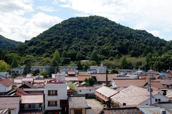
Utsubuki-yama is a 204 m hill rising right next to central Kurayoshi City, Tottori Prefecture, and serves as the city's symbolic landmark. Its summit holds the ruins of the medieval Utsubuki Castle, and the name draws on a legend of a heavenly maiden's child mourning his celestial mother on this peak. The hill is cloaked in old-growth evergreen broadleaf forest of Castanopsis sieboldii and Machilus, with over 220 tree species; it is one of the Forestry Agency's "100 Forests for Forest Bathing." At the foot, Utsubuki Park is included in Japan's "100 Best Cherry-Blossom Sites." The mountain features in the Chūgoku 100 Famous Mountains, Mountains of Tottori (Bunken-tozan-guide) and Chūgoku 100 Mountains lists.
Mt. Utsubuki at a glance
- Weather: The most settled day in the next 7 days is Wed, November 4: clear, gusts up to 10 m/s. Fri, Nov 6, Sat, Nov 7: strong wind (gusts up to 16 m/s).
Mt. Utsubuki weather (hourly, 14 days)
Sunrise today 06:27, sunset 17:09
| Tue, 11/3 | Wed, 11/4 | Thu, 11/5 | Fri, 11/6 | Sat, 11/7 | Sun, 11/8 | Mon, 11/9 | Tue, 11/10 | Wed, 11/11 | Thu, 11/12 | Fri, 11/13 | Sat, 11/14 | Sun, 11/15 | Mon, 11/16 | Tue, 11/17 | |||||||||||||||||||||||||||||||||||||||||||||||||||||||||||||||||||||||
|---|---|---|---|---|---|---|---|---|---|---|---|---|---|---|---|---|---|---|---|---|---|---|---|---|---|---|---|---|---|---|---|---|---|---|---|---|---|---|---|---|---|---|---|---|---|---|---|---|---|---|---|---|---|---|---|---|---|---|---|---|---|---|---|---|---|---|---|---|---|---|---|---|---|---|---|---|---|---|---|---|---|---|---|---|---|
| Japan time | 15 | 17 | 19 | 21 | 23 | 1 | 3 | 5 | 7 | 9 | 11 | 13 | 15 | 18 | 21 | 0 | 3 | 6 | 9 | 12 | 15 | 18 | 21 | 0 | 3 | 6 | 9 | 12 | 15 | 18 | 21 | 0 | 3 | 6 | 9 | 12 | 15 | 18 | 21 | 0 | 3 | 6 | 9 | 12 | 15 | 18 | 21 | 0 | 3 | 6 | 9 | 15 | 21 | 3 | 9 | 15 | 21 | 3 | 9 | 15 | 21 | 3 | 9 | 15 | 21 | 3 | 9 | 15 | 21 | 3 | 9 | 15 | 21 | 3 | 9 | 15 | 21 | 3 | 9 | 15 | 21 | 3 | 9 | 15 | |
  |   |   |   | | |   |   |   | | | |   |   | | | | | | |   | | | | | | | | | |   | | | |   | | | | | | | | | | | | | | | | | | | | | | | | | | | |  | | | | | | |  | | | | | | | | | | | | | | | ||
| Temperature | °C | 14° | 14° | 13° | 13° | 12° | 10° | 10° | 9° | 10° | 15° | 17° | 17° | 17° | 14° | 13° | 14° | 13° | 13° | 17° | 17° | 15° | 15° | 15° | 14° | 14° | 13° | 15° | 17° | 15° | 13° | 12° | 12° | 11° | 11° | 12° | 13° | 12° | 12° | 11° | 11° | 8° | 7° | 13° | 14° | 14° | 12° | 11° | 11° | 11° | 10° | 12° | 14° | 9° | 7° | 12° | 13° | 9° | 9° | 10° | 11° | 10° | 8° | 12° | 15° | 10° | 10° | 12° | 12° | 10° | 9° | 12° | 15° | 11° | 14° | 15° | 14° | 14° | 14° | 14° | 12° | 10° | 9° | 10° | 11° |
| Precipitation | mm | 0.4 | 0.5 | 0.8 | 0.6 | 0.7 | 0.3 | 0.2 | 0.3 | 0.4 | 4.4 | 2.4 | 0.7 | 9 | 0.6 | 0.6 | 1.0 | 0.8 | 0.1 | 0.1 | 0.3 | 1.2 | 1.5 | 0.1 | 1.7 | 2.0 | 2.2 | 0.5 | 1.0 | 0.5 | 1.5 | 2.1 | 0.8 | 4.3 | 16 | 1.5 | 10 | 13 | 3.1 | 0.1 | |||||||||||||||||||||||||||||||||||||||||||||
| New snow | cm | ||||||||||||||||||||||||||||||||||||||||||||||||||||||||||||||||||||||||||||||||||||
| Snow depth | cm | 0 | 0 | 0 | 0 | 0 | 0 | 0 | 0 | 0 | 0 | 0 | 0 | 0 | 0 | 0 | 0 | 0 | 0 | 0 | 0 | 0 | 0 | 0 | 0 | 0 | 0 | 0 | 0 | 0 | 0 | 0 | 0 | 0 | 0 | 0 | 0 | 0 | 0 | 0 | 0 | 0 | 0 | 0 | 0 | 0 | 0 | 0 | 0 | 0 | 0 | 0 | 0 | 0 | 0 | 0 | 0 | 0 | 0 | 0 | 0 | 0 | 0 | 0 | 0 | 0 | 0 | 0 | 0 | 0 | 0 | 0 | 0 | 0 | 0 | 0 | 0 | 0 | 0 | 0 | 0 | 0 | 0 | 0 | 0 |
| Wind | m/s | 3 | 2 | 2 | 1 | 1 | 1 | 2 | 2 | 3 | 2 | 4 | 4 | 4 | 1 | 2 | 0 | 2 | 2 | 0 | 1 | 1 | 1 | 1 | 1 | 2 | 3 | 3 | 7 | 6 | 6 | 7 | 6 | 7 | 7 | 7 | 6 | 6 | 4 | 2 | 1 | 2 | 3 | 2 | 4 | 3 | 2 | 2 | 1 | 1 | 2 | 2 | 4 | 2 | 2 | 2 | 6 | 6 | 6 | 5 | 4 | 1 | 3 | 2 | 4 | 2 | 2 | 5 | 4 | 3 | 1 | 1 | 3 | 4 | 4 | 3 | 6 | 2 | 4 | 4 | 8 | 5 | 3 | 3 | 2 |
| Wind gusts | m/s | 8 | 7 | 4 | 3 | 2 | 2 | 4 | 4 | 5 | 6 | 8 | 9 | 10 | 9 | 4 | 4 | 4 | 6 | 4 | 4 | 4 | 5 | 3 | 5 | 6 | 5 | 7 | 15 | 16 | 14 | 14 | 14 | 14 | 14 | 16 | 15 | 14 | 13 | 8 | 5 | 4 | 6 | 6 | 9 | 9 | 6 | 5 | 4 | 3 | 5 | 6 | 11 | 9 | 5 | 5 | 15 | 14 | 18 | 14 | 12 | 9 | 6 | 6 | 9 | 9 | 5 | 10 | 11 | 10 | 6 | 6 | 8 | 8 | 10 | 10 | 16 | 17 | 10 | 8 | 16 | 16 | 10 | 7 | 8 |
| Wind dir. | ↓ | ↓ | ↓ | ↓ | ↓ | ↓ | ↓ | ↓ | ↓ | ↓ | ↓ | ↓ | ↓ | ↓ | ↓ | ↓ | ↓ | ↓ | ↓ | ↓ | ↓ | ↓ | ↓ | ↓ | ↓ | ↓ | ↓ | ↓ | ↓ | ↓ | ↓ | ↓ | ↓ | ↓ | ↓ | ↓ | ↓ | ↓ | ↓ | ↓ | ↓ | ↓ | ↓ | ↓ | ↓ | ↓ | ↓ | ↓ | ↓ | ↓ | ↓ | ↓ | ↓ | ↓ | ↓ | ↓ | ↓ | ↓ | ↓ | ↓ | ↓ | ↓ | ↓ | ↓ | ↓ | ↓ | ↓ | ↓ | ↓ | ↓ | ↓ | ↓ | ↓ | ↓ | ↓ | ↓ | ↓ | ↓ | ↓ | ↓ | ↓ | ↓ | ↓ | ↓ | |
Huts, campsites and lodging near Mt. Utsubuki
Lodging
- まきた
- 倉吉シティホテル
- Misasa Royal Hotel
- Hotel St Palace Kurayoshi
Lists that include Mt. Utsubuki
Mt. Utsubuki facts
- Elevation
- 204 m
- Location
- Kurayoshi, Tottori
35.426477, 133.821995 - Website
- www.kurayoshi-kankou.jp
- Trail Map
- www.kurayoshi-kankou.jp (PDF)
- Wikipedia
- ja.wikipedia.org