
Mt. Teppōginoatama
明神山
Yamanakako, Yamanashi / Yamakita, Kanagawa · Elevation 1,291 m
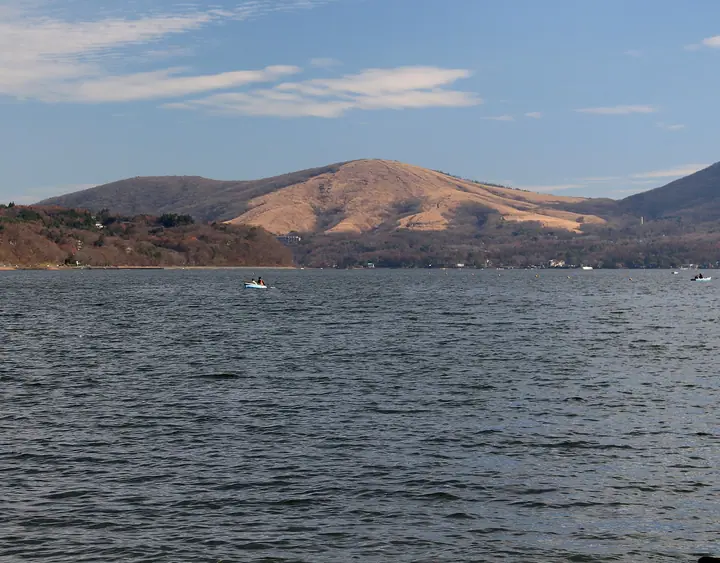
Teppōginoatama is a 1,291 m peak straddling Yamakita Town in Kanagawa and Yamanakako Village in Yamanashi, marking the western tip of the Tanzawa Range. Also known as Myōjinyama, the open grassy summit hosts the Yamanaka Suwa Shrine's inner sanctuary and frames a sweeping view of Mount Fuji rising directly above Lake Yamanaka, earning it a place on Yamanashi's 100 Selected Hiking Courses. From Mikuni Pass or Panorama Terrace it is a one-hour return climb, and a longer loop links it with the neighbouring Mikuniyama on the tri-prefecture border.
Mt. Teppōginoatama at a glance
- Weather: The most settled day in the next 7 days is Fri, November 6: clear, gusts up to 7 m/s.
- Route: The shortest is Teppoginotama (Mount Myojin) Return: about 54 min, 1.5 km, about 120 m of climbing.
Mt. Teppōginoatama weather (hourly, 14 days)
Sunrise today 06:07, sunset 16:49
| Tue, 11/3 | Wed, 11/4 | Thu, 11/5 | Fri, 11/6 | Sat, 11/7 | Sun, 11/8 | Mon, 11/9 | Tue, 11/10 | Wed, 11/11 | Thu, 11/12 | Fri, 11/13 | Sat, 11/14 | Sun, 11/15 | Mon, 11/16 | Tue, 11/17 | |||||||||||||||||||||||||||||||||||||||||||||||||||||||||||||||||||||||
|---|---|---|---|---|---|---|---|---|---|---|---|---|---|---|---|---|---|---|---|---|---|---|---|---|---|---|---|---|---|---|---|---|---|---|---|---|---|---|---|---|---|---|---|---|---|---|---|---|---|---|---|---|---|---|---|---|---|---|---|---|---|---|---|---|---|---|---|---|---|---|---|---|---|---|---|---|---|---|---|---|---|---|---|---|---|
| Japan time | 15 | 17 | 19 | 21 | 23 | 1 | 3 | 5 | 7 | 9 | 11 | 13 | 15 | 18 | 21 | 0 | 3 | 6 | 9 | 12 | 15 | 18 | 21 | 0 | 3 | 6 | 9 | 12 | 15 | 18 | 21 | 0 | 3 | 6 | 9 | 12 | 15 | 18 | 21 | 0 | 3 | 6 | 9 | 12 | 15 | 18 | 21 | 0 | 3 | 6 | 9 | 15 | 21 | 3 | 9 | 15 | 21 | 3 | 9 | 15 | 21 | 3 | 9 | 15 | 21 | 3 | 9 | 15 | 21 | 3 | 9 | 15 | 21 | 3 | 9 | 15 | 21 | 3 | 9 | 15 | 21 | 3 | 9 | 15 | |
  |   | | | | | |   |   | | | | | | | | | | |   | | | | |   | |  | |   |  | |   | | | | | | | |   | | | | | | | | | | |   | | | | | | | | | |   |  | | | | | | | | | | | | | | | | | | | | | | | ||
| Temperature | °C | 10° | 9° | 8° | 8° | 8° | 7° | 6° | 6° | 6° | 7° | 8° | 8° | 7° | 6° | 6° | 6° | 7° | 7° | 10° | 15° | 13° | 11° | 9° | 6° | 6° | 6° | 14° | 18° | 15° | 10° | 9° | 9° | 8° | 7° | 10° | 12° | 9° | 6° | 5° | 6° | 5° | 4° | 8° | 11° | 9° | 7° | 6° | 5° | 5° | 5° | 6° | 8° | 5° | 3° | 5° | 8° | 4° | 2° | 5° | 9° | 0° | 0° | 5° | 7° | 5° | 0° | 8° | 10° | 3° | 3° | 4° | 7° | 3° | 1° | 9° | 12° | 8° | 9° | 13° | 16° | 7° | 6° | 4° | 6° |
| Precipitation | mm | 1.1 | 0.4 | 0.5 | 0.8 | 0.2 | 0.2 | 0.2 | 0.2 | 0.5 | 0.6 | 1.3 | 4.2 | 11 | 19 | 9 | 5 | 0.8 | 1.8 | 0.2 | 0.4 | 2.2 | 0.3 | 1.3 | 1.6 | 0.2 | 0.3 | 0.6 | 0.3 | 0.1 | 0.4 | 0.1 | 10 | 25 | 0.8 | 0.5 | 0.2 | ||||||||||||||||||||||||||||||||||||||||||||||||
| New snow | cm | ||||||||||||||||||||||||||||||||||||||||||||||||||||||||||||||||||||||||||||||||||||
| Snow depth | cm | 0 | 0 | 0 | 0 | 0 | 0 | 0 | 0 | 0 | 0 | 0 | 0 | 0 | 0 | 0 | 0 | 0 | 0 | 0 | 0 | 0 | 0 | 0 | 0 | 0 | 0 | 0 | 0 | 0 | 0 | 0 | 0 | 0 | 0 | 0 | 0 | 0 | 0 | 0 | 0 | 0 | 0 | 0 | 0 | 0 | 0 | 0 | 0 | 0 | 0 | 0 | 0 | 0 | 0 | 0 | 0 | 0 | 0 | 0 | 0 | 0 | 0 | 0 | 0 | 0 | 0 | 0 | 0 | 0 | 0 | 0 | 0 | 0 | 0 | 0 | 0 | 0 | 0 | 0 | 0 | 0 | 0 | 0 | 0 |
| Wind | m/s | 2 | 1 | 1 | 1 | 1 | 1 | 2 | 2 | 2 | 1 | 2 | 2 | 2 | 1 | 1 | 2 | 2 | 2 | 2 | 2 | 2 | 0 | 1 | 1 | 1 | 1 | 1 | 1 | 2 | 1 | 1 | 1 | 2 | 1 | 1 | 1 | 2 | 2 | 0 | 1 | 1 | 0 | 1 | 2 | 3 | 1 | 1 | 1 | 1 | 1 | 1 | 3 | 2 | 3 | 2 | 4 | 1 | 1 | 6 | 4 | 1 | 1 | 1 | 2 | 1 | 1 | 2 | 2 | 1 | 1 | 1 | 2 | 0 | 1 | 1 | 2 | 1 | 0 | 1 | 1 | 2 | 1 | 1 | 2 |
| Wind gusts | m/s | 7 | 6 | 3 | 3 | 3 | 3 | 4 | 4 | 4 | 4 | 5 | 5 | 5 | 5 | 4 | 5 | 5 | 6 | 7 | 8 | 5 | 5 | 3 | 3 | 4 | 4 | 4 | 5 | 7 | 5 | 3 | 3 | 5 | 4 | 5 | 6 | 7 | 6 | 4 | 2 | 2 | 2 | 4 | 7 | 10 | 8 | 3 | 3 | 3 | 3 | 4 | 9 | 7 | 7 | 7 | 10 | 10 | 4 | 20 | 18 | 10 | 3 | 4 | 7 | 6 | 4 | 6 | 10 | 5 | 3 | 4 | 6 | 6 | 3 | 4 | 9 | 6 | 5 | 4 | 7 | 5 | 5 | 5 | 7 |
| Wind dir. | ↓ | ↓ | ↓ | ↓ | ↓ | ↓ | ↓ | ↓ | ↓ | ↓ | ↓ | ↓ | ↓ | ↓ | ↓ | ↓ | ↓ | ↓ | ↓ | ↓ | ↓ | ↓ | ↓ | ↓ | ↓ | ↓ | ↓ | ↓ | ↓ | ↓ | ↓ | ↓ | ↓ | ↓ | ↓ | ↓ | ↓ | ↓ | ↓ | ↓ | ↓ | ↓ | ↓ | ↓ | ↓ | ↓ | ↓ | ↓ | ↓ | ↓ | ↓ | ↓ | ↓ | ↓ | ↓ | ↓ | ↓ | ↓ | ↓ | ↓ | ↓ | ↓ | ↓ | ↓ | ↓ | ↓ | ↓ | ↓ | ↓ | ↓ | ↓ | ↓ | ↓ | ↓ | ↓ | ↓ | ↓ | ↓ | ↓ | ↓ | ↓ | ↓ | ↓ | ||
Mt. Teppōginoatama hiking routes
Hiking times are estimates calculated from the terrain.
Huts, campsites and lodging near Mt. Teppōginoatama
Campsites
- ディアベースオートキャンプ場
- 山中湖ふじのもりオートキャンプ場
- 湖山荘キャンプ場
- sotosotodays CAMPGROUNDS Yamanaka Lake Misaki
- ボーイスカウト日本連盟 山中野営場
Lodging
- 茶居夢
- exiv
- CARO FORESTA
- ペンション・モーツァルト
- ペンション ピッコロ・モンド
Mt. Teppōginoatama facts
- Also known as
- 後陣山 · 棍棒木ノ頭 · コンボーギノ頭
- Elevation
- 1,291 m
- Location
- Yamanakako, Yamanashi / Yamakita, Kanagawa
35.411193, 138.917919 - Website
- yamanashi-hiking100.jp
- Wikipedia
- ja.wikipedia.org