
Mt. Takatoriyama
高取山
Kobe, Hyogo · Elevation 328 m
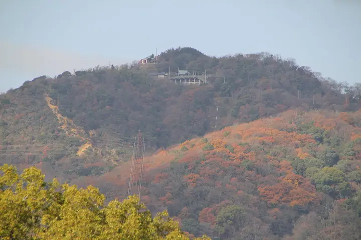
Mount Takatoriyama (328 m) is an isolated peak of the western Rokko Range straddling Nagata and Suma wards of Kobe, within Setonaikai National Park. Also known as Kanade-yama, it has long been a site of pilgrimage centred on Takatori Shrine, with four traditional teahouses still scattered along the path. Its summit commands views of Kobe city, the port, Kobe Airport and across to Awaji Island, and it serves as a key relay point on the Rokko Zenzan Traverse. The peak is listed in Furusato Hyogo 100 Mountains.
Mt. Takatoriyama at a glance
- Weather: The most settled day in the next 7 days is Mon, November 9: clear, gusts up to 5 m/s.
Mt. Takatoriyama weather (hourly, 14 days)
Sunrise today 06:21, sunset 17:05
| Tue, 11/3 | Wed, 11/4 | Thu, 11/5 | Fri, 11/6 | Sat, 11/7 | Sun, 11/8 | Mon, 11/9 | Tue, 11/10 | Wed, 11/11 | Thu, 11/12 | Fri, 11/13 | Sat, 11/14 | Sun, 11/15 | Mon, 11/16 | Tue, 11/17 | |||||||||||||||||||||||||||||||||||||||||||||||||||||||||||||||||||||||
|---|---|---|---|---|---|---|---|---|---|---|---|---|---|---|---|---|---|---|---|---|---|---|---|---|---|---|---|---|---|---|---|---|---|---|---|---|---|---|---|---|---|---|---|---|---|---|---|---|---|---|---|---|---|---|---|---|---|---|---|---|---|---|---|---|---|---|---|---|---|---|---|---|---|---|---|---|---|---|---|---|---|---|---|---|---|
| Japan time | 15 | 17 | 19 | 21 | 23 | 1 | 3 | 5 | 7 | 9 | 11 | 13 | 15 | 18 | 21 | 0 | 3 | 6 | 9 | 12 | 15 | 18 | 21 | 0 | 3 | 6 | 9 | 12 | 15 | 18 | 21 | 0 | 3 | 6 | 9 | 12 | 15 | 18 | 21 | 0 | 3 | 6 | 9 | 12 | 15 | 18 | 21 | 0 | 3 | 6 | 9 | 15 | 21 | 3 | 9 | 15 | 21 | 3 | 9 | 15 | 21 | 3 | 9 | 15 | 21 | 3 | 9 | 15 | 21 | 3 | 9 | 15 | 21 | 3 | 9 | 15 | 21 | 3 | 9 | 15 | 21 | 3 | 9 | 15 | |
  | |   | | | | | | | | |   | |   |   |   |   | |   | |  |  |   | | | | |   | | | | | | | | | | | | | | | | | | | | | | | | | |   | | | | | |   | |  | | | | | | | | | | | | | | | | | | | |  | | | ||
| Temperature | °C | 17° | 15° | 14° | 13° | 13° | 13° | 12° | 12° | 12° | 14° | 15° | 17° | 18° | 16° | 16° | 14° | 15° | 15° | 15° | 17° | 19° | 17° | 17° | 18° | 16° | 15° | 16° | 17° | 18° | 15° | 13° | 11° | 10° | 9° | 11° | 13° | 13° | 10° | 9° | 9° | 9° | 9° | 11° | 14° | 14° | 12° | 12° | 12° | 11° | 12° | 13° | 15° | 12° | 11° | 12° | 14° | 11° | 8° | 9° | 12° | 8° | 8° | 10° | 13° | 12° | 10° | 12° | 13° | 8° | 8° | 10° | 14° | 13° | 12° | 13° | 16° | 15° | 16° | 15° | 16° | 11° | 7° | 9° | 12° |
| Precipitation | mm | 3.1 | 3.7 | 1.5 | 1.3 | 0.1 | 0.6 | 1.4 | 0.1 | 0.1 | 0.2 | 0.1 | 4.2 | 1.4 | 0.3 | ||||||||||||||||||||||||||||||||||||||||||||||||||||||||||||||||||||||
| New snow | cm | ||||||||||||||||||||||||||||||||||||||||||||||||||||||||||||||||||||||||||||||||||||
| Snow depth | cm | 0 | 0 | 0 | 0 | 0 | 0 | 0 | 0 | 0 | 0 | 0 | 0 | 0 | 0 | 0 | 0 | 0 | 0 | 0 | 0 | 0 | 0 | 0 | 0 | 0 | 0 | 0 | 0 | 0 | 0 | 0 | 0 | 0 | 0 | 0 | 0 | 0 | 0 | 0 | 0 | 0 | 0 | 0 | 0 | 0 | 0 | 0 | 0 | 0 | 0 | 0 | 0 | 0 | 0 | 0 | 0 | 0 | 0 | 0 | 0 | 0 | 0 | 0 | 0 | 0 | 0 | 0 | 0 | 0 | 0 | 0 | 0 | 0 | 0 | 0 | 0 | 0 | 0 | 0 | 0 | 0 | 0 | 0 | 0 |
| Wind | m/s | 3 | 4 | 5 | 5 | 4 | 4 | 4 | 4 | 4 | 4 | 3 | 3 | 4 | 6 | 6 | 6 | 4 | 4 | 4 | 1 | 0 | 2 | 2 | 6 | 6 | 2 | 5 | 6 | 6 | 5 | 6 | 6 | 3 | 4 | 5 | 6 | 6 | 4 | 3 | 2 | 3 | 2 | 2 | 3 | 3 | 3 | 3 | 2 | 2 | 1 | 1 | 2 | 2 | 2 | 3 | 5 | 6 | 4 | 5 | 7 | 3 | 3 | 2 | 3 | 2 | 3 | 6 | 5 | 3 | 2 | 2 | 2 | 2 | 4 | 5 | 4 | 4 | 2 | 3 | 7 | 7 | 3 | 3 | 3 |
| Wind gusts | m/s | 7 | 8 | 8 | 9 | 8 | 7 | 8 | 8 | 7 | 8 | 7 | 6 | 7 | 10 | 11 | 11 | 10 | 7 | 6 | 7 | 4 | 4 | 4 | 10 | 12 | 9 | 9 | 11 | 11 | 11 | 10 | 11 | 10 | 7 | 10 | 11 | 11 | 11 | 7 | 5 | 5 | 5 | 5 | 6 | 7 | 7 | 6 | 5 | 4 | 4 | 3 | 5 | 5 | 4 | 6 | 11 | 10 | 11 | 10 | 13 | 13 | 6 | 5 | 6 | 6 | 7 | 11 | 13 | 10 | 6 | 6 | 5 | 5 | 7 | 9 | 8 | 7 | 7 | 9 | 12 | 13 | 12 | 7 | 7 |
| Wind dir. | ↓ | ↓ | ↓ | ↓ | ↓ | ↓ | ↓ | ↓ | ↓ | ↓ | ↓ | ↓ | ↓ | ↓ | ↓ | ↓ | ↓ | ↓ | ↓ | ↓ | ↓ | ↓ | ↓ | ↓ | ↓ | ↓ | ↓ | ↓ | ↓ | ↓ | ↓ | ↓ | ↓ | ↓ | ↓ | ↓ | ↓ | ↓ | ↓ | ↓ | ↓ | ↓ | ↓ | ↓ | ↓ | ↓ | ↓ | ↓ | ↓ | ↓ | ↓ | ↓ | ↓ | ↓ | ↓ | ↓ | ↓ | ↓ | ↓ | ↓ | ↓ | ↓ | ↓ | ↓ | ↓ | ↓ | ↓ | ↓ | ↓ | ↓ | ↓ | ↓ | ↓ | ↓ | ↓ | ↓ | ↓ | ↓ | ↓ | ↓ | ↓ | ↓ | ↓ | ↓ | |
Huts, campsites and lodging near Mt. Takatoriyama
Campsites
- Campground
- Auto-Campground
Lodging
- ホテルウィングインターナショナル
- Kobe Luminous Hotel
- Kotobukiro
- ‘Hiyodori’ Recreational Center
- てるや
Lists that include Mt. Takatoriyama
100 Mountains of Our Home Hyogo · Full Rokko Mountain Traverse
Mt. Takatoriyama facts
- Also known as
- 神撫山(かんなでやま)
- Elevation
- 328 m
- Location
- Kobe, Hyogo
34.676501, 135.130248 - National Park
- 瀬戸内海国立公園
- Website
- www.city.kobe.lg.jp
- Trail Map
- www.city.kobe.lg.jp (PDF)
- Access Information
- www.city.kobe.lg.jp
- Wikipedia
- ja.wikipedia.org