
Mt. Sobu
蘇武岳
Toyooka, Hyogo / Kami, Hyogo · Elevation 1,074 m
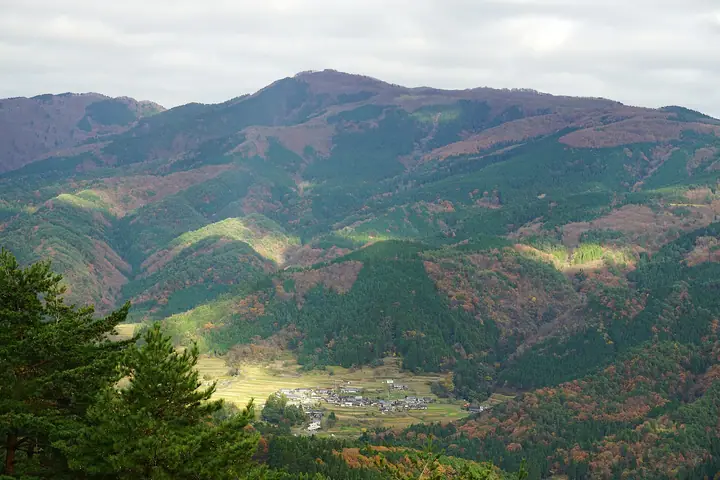
Sobudake is a 1,074.4 m first-class triangulation peak straddling the border of Toyooka City and Muraoka, Kami Town in Hyogo, set in the northern part of Hyōnosen-Ushiroyama-Nagisan Quasi-National Park. The summit offers a full 360-degree panorama, taking in the Ase Gorge, Hyōnosen, Hachibuseyama, Torokawayama and Ōginosen across the Tajima–Inaba ranges, with the Sea of Japan visible on clear days. Beloved by adventurers Naomi Uemura and Buntarō Katō as their home mountain, it is climbed from the Ōnuka trailhead on the Muraoka side and the Banba trailhead on the Toyooka–Hidaka side, and is included in the Kansai 100 and Furusato Hyogo 100.
Mt. Sobu at a glance
- Weather: The most settled day in the next 7 days is Wed, November 4: clear, gusts up to 7 m/s. Fri, Nov 6, Sat, Nov 7: strong wind (gusts up to 16 m/s).
- Route: The shortest is Sobudake and Osugiyama via the Giant Tree Valley: about 5 h 55 min, 9.9 km, about 950 m of climbing.
Mt. Sobu weather (hourly, 14 days)
Sunrise today 06:24, sunset 17:06
| Tue, 11/3 | Wed, 11/4 | Thu, 11/5 | Fri, 11/6 | Sat, 11/7 | Sun, 11/8 | Mon, 11/9 | Tue, 11/10 | Wed, 11/11 | Thu, 11/12 | Fri, 11/13 | Sat, 11/14 | Sun, 11/15 | Mon, 11/16 | Tue, 11/17 | |||||||||||||||||||||||||||||||||||||||||||||||||||||||||||||||||||||||
|---|---|---|---|---|---|---|---|---|---|---|---|---|---|---|---|---|---|---|---|---|---|---|---|---|---|---|---|---|---|---|---|---|---|---|---|---|---|---|---|---|---|---|---|---|---|---|---|---|---|---|---|---|---|---|---|---|---|---|---|---|---|---|---|---|---|---|---|---|---|---|---|---|---|---|---|---|---|---|---|---|---|---|---|---|---|
| Japan time | 15 | 17 | 19 | 21 | 23 | 1 | 3 | 5 | 7 | 9 | 11 | 13 | 15 | 18 | 21 | 0 | 3 | 6 | 9 | 12 | 15 | 18 | 21 | 0 | 3 | 6 | 9 | 12 | 15 | 18 | 21 | 0 | 3 | 6 | 9 | 12 | 15 | 18 | 21 | 0 | 3 | 6 | 9 | 12 | 15 | 18 | 21 | 0 | 3 | 6 | 9 | 15 | 21 | 3 | 9 | 15 | 21 | 3 | 9 | 15 | 21 | 3 | 9 | 15 | 21 | 3 | 9 | 15 | 21 | 3 | 9 | 15 | 21 | 3 | 9 | 15 | 21 | 3 | 9 | 15 | 21 | 3 | 9 | 15 | |
  | |   |   | | | | |   |  | | | | | |   | | | |   | | | | | | |   |   | | | |   | | | | | | |   |   | | |   | | | | | | | | | | | | | | | | | | | | | | | | | | | | | | | | | | | | | | | | | | ||
| Temperature | °C | 10° | 8° | 7° | 7° | 6° | 6° | 6° | 6° | 6° | 9° | 12° | 13° | 12° | 8° | 8° | 9° | 9° | 9° | 10° | 16° | 14° | 10° | 10° | 9° | 10° | 9° | 11° | 13° | 11° | 8° | 6° | 5° | 5° | 4° | 6° | 7° | 6° | 4° | 5° | 4° | 4° | 3° | 9° | 10° | 8° | 6° | 6° | 6° | 5° | 5° | 7° | 8° | 4° | 5° | 8° | 9° | 4° | 3° | 4° | 5° | 4° | 3° | 7° | 10° | 3° | 4° | 5° | 6° | 3° | 2° | 7° | 12° | 2° | 4° | 10° | 11° | 11° | 9° | 9° | 7° | 4° | 3° | 5° | 6° |
| Precipitation | mm | 0.8 | 0.4 | 0.3 | 0.2 | 2.8 | 0.3 | 0.7 | 0.9 | 3.9 | 11 | 1.0 | 0.3 | 0.4 | 0.6 | 0.3 | 0.2 | 0.3 | 0.3 | 0.4 | 0.2 | 0.2 | 0.2 | 0.6 | 2.8 | 0.7 | 0.2 | 1.4 | 1.3 | 1.6 | 1.1 | 0.8 | 0.1 | 0.8 | 3.8 | 0.6 | 10 | 2.3 | 4.1 | 10 | 6 | 0.1 | 0.1 | 0.1 | |||||||||||||||||||||||||||||||||||||||||
| New snow | cm | ||||||||||||||||||||||||||||||||||||||||||||||||||||||||||||||||||||||||||||||||||||
| Snow depth | cm | 0 | 0 | 0 | 0 | 0 | 0 | 0 | 0 | 0 | 0 | 0 | 0 | 0 | 0 | 0 | 0 | 0 | 0 | 0 | 0 | 0 | 0 | 0 | 0 | 0 | 0 | 0 | 0 | 0 | 0 | 0 | 0 | 0 | 0 | 0 | 0 | 0 | 0 | 0 | 0 | 0 | 0 | 0 | 0 | 0 | 0 | 0 | 0 | 0 | 0 | 0 | 0 | 0 | 0 | 0 | 0 | 0 | 0 | 0 | 0 | 0 | 0 | 0 | 0 | 0 | 0 | 0 | 0 | 0 | 0 | 0 | 0 | 0 | 0 | 0 | 0 | 0 | 0 | 0 | 0 | 0 | 0 | 0 | 0 |
| Wind | m/s | 3 | 1 | 0 | 1 | 1 | 1 | 1 | 0 | 0 | 1 | 2 | 2 | 3 | 0 | 2 | 2 | 1 | 1 | 1 | 1 | 2 | 2 | 1 | 2 | 2 | 3 | 3 | 6 | 5 | 3 | 4 | 4 | 4 | 4 | 6 | 6 | 5 | 2 | 2 | 2 | 1 | 2 | 3 | 4 | 3 | 1 | 0 | 1 | 1 | 2 | 2 | 3 | 1 | 1 | 2 | 5 | 5 | 7 | 4 | 4 | 2 | 1 | 0 | 3 | 2 | 2 | 4 | 5 | 2 | 1 | 1 | 3 | 1 | 2 | 3 | 4 | 5 | 2 | 3 | 5 | 4 | 2 | 3 | 2 |
| Wind gusts | m/s | 8 | 7 | 3 | 3 | 3 | 3 | 4 | 4 | 3 | 4 | 7 | 7 | 7 | 7 | 5 | 7 | 6 | 4 | 5 | 5 | 6 | 5 | 6 | 8 | 7 | 12 | 12 | 15 | 15 | 13 | 12 | 13 | 12 | 12 | 15 | 16 | 16 | 14 | 7 | 7 | 6 | 6 | 8 | 11 | 12 | 8 | 3 | 3 | 5 | 5 | 6 | 10 | 9 | 5 | 6 | 14 | 14 | 20 | 19 | 14 | 12 | 6 | 5 | 8 | 8 | 7 | 11 | 13 | 13 | 6 | 4 | 8 | 7 | 6 | 9 | 14 | 16 | 13 | 9 | 13 | 13 | 11 | 8 | 9 |
| Wind dir. | ↓ | ↓ | ↓ | ↓ | ↓ | ↓ | ↓ | ↓ | ↓ | ↓ | ↓ | ↓ | ↓ | ↓ | ↓ | ↓ | ↓ | ↓ | ↓ | ↓ | ↓ | ↓ | ↓ | ↓ | ↓ | ↓ | ↓ | ↓ | ↓ | ↓ | ↓ | ↓ | ↓ | ↓ | ↓ | ↓ | ↓ | ↓ | ↓ | ↓ | ↓ | ↓ | ↓ | ↓ | ↓ | ↓ | ↓ | ↓ | ↓ | ↓ | ↓ | ↓ | ↓ | ↓ | ↓ | ↓ | ↓ | ↓ | ↓ | ↓ | ↓ | ↓ | ↓ | ↓ | ↓ | ↓ | ↓ | ↓ | ↓ | ↓ | ↓ | ↓ | ↓ | ↓ | ↓ | ↓ | ↓ | ↓ | ↓ | ↓ | ↓ | ↓ | ↓ | ↓ | |
Mt. Sobu hiking routes
Hiking times are estimates calculated from the terrain.
Huts, campsites and lodging near Mt. Sobu
Campsites
- 神鍋高原キャンプ場
Lodging
- 奥神鍋ヒュッテ
- しもね
- 志ん屋
Lists that include Mt. Sobu
Kansai 100 Famous Mountains · 100 Mountains of Our Home Hyogo · Elevations of 1003 Mountains of Japan · 1000 Mountains of Japan
Mt. Sobu facts
- Also known as
- 蘇武山(そぶやま) · そぶがたけ
- Elevation
- 1,074 m
- Location
- Toyooka, Hyogo / Kami, Hyogo
35.470793, 134.638084 - National Park
- 氷ノ山後山那岐山国定公園
- Season Opens
- April 1
- Season Closes
- November 30
- Website
- www.kami-tourism.com
- Trail Map
- www.kami-tourism.com (PDF)
- Wikipedia
- ja.wikipedia.org