
Mt. Shirahatayama
白旗山
Sapporo, Hokkaido · Elevation 321 m
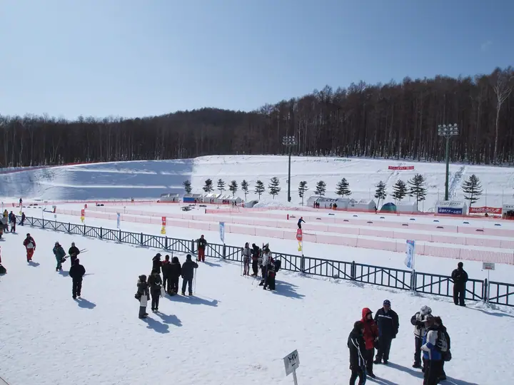
Mt. Shirahatayama, 321.5 m, is a low summit in Ariake, Kiyota Ward, Sapporo, Hokkaido — said to be named after the white flags planted by Meiji-era surveyors. Designated by the city as a 1,063 ha 'urban environmental forest', it is one of Kiyota Ward's emblems alongside the Abetsu River and the Hiraoka plum grove. At its base lies Shirahata-yama Stadium — Asia's first FIS-certified 25 km cross-country ski course, opened in December 1990 and host to the Asian Winter Games, Universiade and FIS Nordic World Ski Championships — together with two grass soccer pitches. The Sapporo City Greening Promotion Department maintains a 4-to-6-km network of nature trails through the Fureai-no-Mori and Shizen-kansatsu-no-Mori sectors, accessible by Chuo bus from Fukuzumi or Ōyachi subway stations. The peak is one of the 'Sapporo 50 Mountains'.
Mt. Shirahatayama at a glance
- Weather: The most settled day in the next 7 days is Mon, November 9: clear, gusts up to 8 m/s.
Mt. Shirahatayama weather (hourly, 14 days)
Sunrise today 06:10, sunset 16:26
| Tue, 11/3 | Wed, 11/4 | Thu, 11/5 | Fri, 11/6 | Sat, 11/7 | Sun, 11/8 | Mon, 11/9 | Tue, 11/10 | Wed, 11/11 | Thu, 11/12 | Fri, 11/13 | Sat, 11/14 | Sun, 11/15 | Mon, 11/16 | Tue, 11/17 | |||||||||||||||||||||||||||||||||||||||||||||||||||||||||||||||||||||||
|---|---|---|---|---|---|---|---|---|---|---|---|---|---|---|---|---|---|---|---|---|---|---|---|---|---|---|---|---|---|---|---|---|---|---|---|---|---|---|---|---|---|---|---|---|---|---|---|---|---|---|---|---|---|---|---|---|---|---|---|---|---|---|---|---|---|---|---|---|---|---|---|---|---|---|---|---|---|---|---|---|---|---|---|---|---|
| Japan time | 21 | 23 | 1 | 3 | 5 | 7 | 9 | 11 | 13 | 15 | 17 | 19 | 21 | 0 | 3 | 6 | 9 | 12 | 15 | 18 | 21 | 0 | 3 | 6 | 9 | 12 | 15 | 18 | 21 | 0 | 3 | 6 | 9 | 12 | 15 | 18 | 21 | 0 | 3 | 6 | 9 | 12 | 15 | 18 | 21 | 0 | 3 | 6 | 9 | 12 | 15 | 21 | 3 | 9 | 15 | 21 | 3 | 9 | 15 | 21 | 3 | 9 | 15 | 21 | 3 | 9 | 15 | 21 | 3 | 9 | 15 | 21 | 3 | 9 | 15 | 21 | 3 | 9 | 15 | 21 | 3 | 9 | 15 | 21 | |
  |   |   | | |   | | |  | |  | | | | | |   |   | |   |   | | | |   |   | |   | | |   | |   | |   |   | | |   | | | | | | | | | | |   | | | | | | | | | | | | | | | | | | |   | | |  | | | | | | | | | | | | | ||
| Temperature | °C | 1° | 1° | 1° | 1° | 1° | 1° | 5° | 6° | 7° | 6° | 2° | 1° | 1° | 1° | 2° | 2° | 9° | 11° | 12° | 8° | 9° | 9° | 9° | 8° | 9° | 13° | 13° | 7° | 4° | 2° | 0° | 0° | 1° | 2° | 1° | 0° | 0° | 0° | 0° | -1° | 1° | 3° | 1° | 0° | -1° | 0° | -1° | -1° | 1° | 2° | 1° | -1° | -3° | 0° | 1° | -2° | -3° | 1° | 4° | -1° | -2° | 2° | 4° | -1° | -2° | -1° | 0° | 0° | -1° | 1° | 4° | -3° | 1° | 6° | 9° | 7° | 5° | 4° | 2° | 0° | -1° | 2° | 4° | 0° |
| Precipitation | mm | 0.1 | 0.9 | 0.8 | 0.2 | 1.9 | 1.0 | 3.8 | 6 | 0.4 | 0.3 | 0.6 | 0.1 | 0.2 | 0.3 | 0.6 | 0.5 | 0.3 | 0.1 | 0.1 | 0.8 | 1.0 | 0.2 | 0.3 | 0.5 | 0.8 | 0.8 | 0.2 | 3.3 | 1.6 | 0.2 | ||||||||||||||||||||||||||||||||||||||||||||||||||||||
| New snow | cm | <.1 | 0.1 | <.1 | 0.2 | 0.3 | 0.6 | 0.5 | 0.3 | 0.1 | <.1 | <.1 | 0.8 | 1.0 | 0.2 | 0.3 | 0.5 | 0.7 | 0.5 | 0.2 | |||||||||||||||||||||||||||||||||||||||||||||||||||||||||||||||||
| Snow depth | cm | 0 | 0 | <1 | 0 | 0 | 0 | 0 | 0 | 0 | 0 | 0 | 0 | 0 | 0 | 0 | 0 | 0 | 0 | 0 | 0 | 0 | 0 | 0 | 0 | 0 | 0 | 0 | 0 | 0 | 0 | 0 | 0 | 0 | <1 | <1 | <1 | <1 | <1 | <1 | <1 | 1 | <1 | <1 | <1 | <1 | <1 | <1 | <1 | <1 | <1 | <1 | <1 | <1 | <1 | <1 | <1 | <1 | 1 | <1 | <1 | <1 | <1 | <1 | <1 | <1 | <1 | <1 | 1 | 1 | 1 | <1 | <1 | <1 | <1 | 0 | 0 | 0 | 0 | 0 | 0 | 0 | 0 | 0 | 0 |
| Wind | m/s | 2 | 3 | 1 | 1 | 1 | 2 | 3 | 2 | 2 | 2 | 1 | 2 | 2 | 3 | 3 | 3 | 3 | 3 | 2 | 2 | 3 | 2 | 1 | 1 | 1 | 1 | 4 | 1 | 1 | 4 | 5 | 6 | 2 | 5 | 3 | 3 | 3 | 4 | 3 | 3 | 6 | 5 | 5 | 2 | 2 | 1 | 1 | 0 | 1 | 3 | 3 | 1 | 1 | 1 | 3 | 2 | 2 | 3 | 3 | 2 | 1 | 1 | 3 | 1 | 2 | 6 | 4 | 4 | 1 | 1 | 1 | 1 | 3 | 4 | 3 | 2 | 1 | 5 | 7 | 5 | 4 | 2 | 2 | 2 |
| Wind gusts | m/s | 3 | 5 | 6 | 5 | 3 | 4 | 8 | 8 | 6 | 6 | 5 | 3 | 5 | 6 | 7 | 6 | 7 | 7 | 6 | 5 | 6 | 6 | 4 | 3 | 2 | 5 | 9 | 10 | 5 | 9 | 12 | 12 | 12 | 13 | 12 | 7 | 7 | 8 | 9 | 7 | 12 | 13 | 12 | 12 | 4 | 3 | 3 | 2 | 4 | 8 | 8 | 7 | 2 | 4 | 7 | 6 | 5 | 7 | 9 | 7 | 5 | 4 | 8 | 6 | 4 | 14 | 15 | 9 | 8 | 3 | 5 | 3 | 6 | 8 | 9 | 6 | 7 | 11 | 14 | 14 | 10 | 8 | 7 | 4 |
| Wind dir. | ↓ | ↓ | ↓ | ↓ | ↓ | ↓ | ↓ | ↓ | ↓ | ↓ | ↓ | ↓ | ↓ | ↓ | ↓ | ↓ | ↓ | ↓ | ↓ | ↓ | ↓ | ↓ | ↓ | ↓ | ↓ | ↓ | ↓ | ↓ | ↓ | ↓ | ↓ | ↓ | ↓ | ↓ | ↓ | ↓ | ↓ | ↓ | ↓ | ↓ | ↓ | ↓ | ↓ | ↓ | ↓ | ↓ | ↓ | ↓ | ↓ | ↓ | ↓ | ↓ | ↓ | ↓ | ↓ | ↓ | ↓ | ↓ | ↓ | ↓ | ↓ | ↓ | ↓ | ↓ | ↓ | ↓ | ↓ | ↓ | ↓ | ↓ | ↓ | ↓ | ↓ | ↓ | ↓ | ↓ | ↓ | ↓ | ↓ | ↓ | ↓ | ↓ | ↓ | ↓ | |
Huts, campsites and lodging near Mt. Shirahatayama
Campsites
- Auto Resort Takino
Lists that include Mt. Shirahatayama
Mt. Shirahatayama facts
- Elevation
- 321 m
- Location
- Sapporo, Hokkaido
42.948919, 141.423022 - Website
- www.city.sapporo.jp
- Trail Map
- www.city.sapporo.jp (PDF)
- Wikipedia
- ja.wikipedia.org