
Mt. Raizan
雷山
Itoshima, Fukuoka · Elevation 955 m
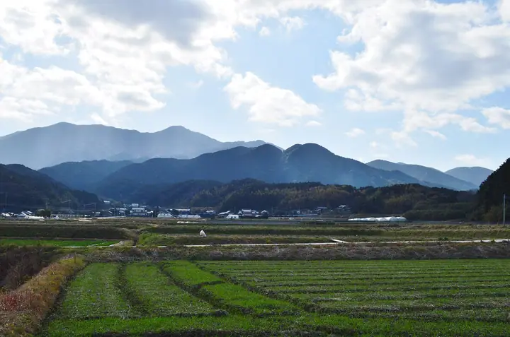
Mt. Raizan (955 m) rises on the border of Itoshima City in Fukuoka and Fuji Town in Saga's Saga City, on the Sefuri Range; its name ("Thunder Mountain") comes from the thunder god enshrined on its slopes. Halfway up the north face stands the ancient temple Raizan Sennyo-ji Daihiō-in, popularly known as Raizan-Kannon, home to a wooden Senju-Kannon statue designated an Important Cultural Property. The summit offers sweeping views from Hakata Bay and the Genkai Sea across the Sefuri Range, and the standard outing combines it with neighbouring Mt. Iwara on a ridge traverse. It is counted among the 100 Famous Mountains of Kyūshū, with trails maintained on the Itoshima Tourism Association's "Iwara-Raizan-Hagane" map.
Mt. Raizan at a glance
- Weather: The most settled day in the next 7 days is Sun, November 8: clear, gusts up to 6 m/s.
- Route: The shortest is Mount Raizan Circuit via Seiga Falls: about 3 h 45 min, 6.4 km, about 650 m of climbing.
Mt. Raizan weather (hourly, 14 days)
Sunrise today 06:39, sunset 17:27
| Tue, 11/3 | Wed, 11/4 | Thu, 11/5 | Fri, 11/6 | Sat, 11/7 | Sun, 11/8 | Mon, 11/9 | Tue, 11/10 | Wed, 11/11 | Thu, 11/12 | Fri, 11/13 | Sat, 11/14 | Sun, 11/15 | Mon, 11/16 | Tue, 11/17 | |||||||||||||||||||||||||||||||||||||||||||||||||||||||||||||||||||||||
|---|---|---|---|---|---|---|---|---|---|---|---|---|---|---|---|---|---|---|---|---|---|---|---|---|---|---|---|---|---|---|---|---|---|---|---|---|---|---|---|---|---|---|---|---|---|---|---|---|---|---|---|---|---|---|---|---|---|---|---|---|---|---|---|---|---|---|---|---|---|---|---|---|---|---|---|---|---|---|---|---|---|---|---|---|---|
| Japan time | 15 | 17 | 19 | 21 | 23 | 1 | 3 | 5 | 7 | 9 | 11 | 13 | 15 | 18 | 21 | 0 | 3 | 6 | 9 | 12 | 15 | 18 | 21 | 0 | 3 | 6 | 9 | 12 | 15 | 18 | 21 | 0 | 3 | 6 | 9 | 12 | 15 | 18 | 21 | 0 | 3 | 6 | 9 | 12 | 15 | 18 | 21 | 0 | 3 | 6 | 9 | 15 | 21 | 3 | 9 | 15 | 21 | 3 | 9 | 15 | 21 | 3 | 9 | 15 | 21 | 3 | 9 | 15 | 21 | 3 | 9 | 15 | 21 | 3 | 9 | 15 | 21 | 3 | 9 | 15 | 21 | 3 | 9 | 15 | |
  |   |   |   | | | | | | | | | |   | | | |   | | | |   | | | | |   |   |  |  | | | | | | | | | | | | | | | | | | | | |   | | | | | |   | | | |   | | | |  | | | | | | | | | | | | | | | | | | | | ||
| Temperature | °C | 12° | 10° | 9° | 9° | 9° | 8° | 8° | 8° | 7° | 9° | 13° | 14° | 14° | 10° | 10° | 10° | 11° | 11° | 14° | 15° | 15° | 14° | 13° | 12° | 11° | 9° | 11° | 12° | 10° | 7° | 6° | 5° | 4° | 3° | 5° | 7° | 7° | 3° | 2° | 2° | 3° | 3° | 8° | 10° | 9° | 7° | 7° | 7° | 7° | 6° | 9° | 10° | 5° | 5° | 8° | 8° | 7° | 5° | 6° | 8° | 3° | 2° | 8° | 10° | 4° | 5° | 10° | 11° | 6° | 4° | 9° | 14° | 8° | 9° | 11° | 13° | 11° | 11° | 11° | 12° | 7° | 5° | 8° | 10° |
| Precipitation | mm | 0.1 | 0.5 | 0.9 | 0.2 | 0.1 | 1.3 | 2.1 | 3.1 | 1.0 | 1.3 | 1.3 | 0.3 | 0.2 | 0.8 | 0.2 | 0.6 | 0.9 | 0.1 | 0.2 | 0.8 | 5.0 | 17 | 10 | 1.9 | 2.6 | 0.4 | 0.4 | |||||||||||||||||||||||||||||||||||||||||||||||||||||||||
| New snow | cm | ||||||||||||||||||||||||||||||||||||||||||||||||||||||||||||||||||||||||||||||||||||
| Snow depth | cm | 0 | 0 | 0 | 0 | 0 | 0 | 0 | 0 | 0 | 0 | 0 | 0 | 0 | 0 | 0 | 0 | 0 | 0 | 0 | 0 | 0 | 0 | 0 | 0 | 0 | 0 | 0 | 0 | 0 | 0 | 0 | 0 | 0 | 0 | 0 | 0 | 0 | 0 | 0 | 0 | 0 | 0 | 0 | 0 | 0 | 0 | 0 | 0 | 0 | 0 | 0 | 0 | 0 | 0 | 0 | 0 | 0 | 0 | 0 | 0 | 0 | 0 | 0 | 0 | 0 | 0 | 0 | 0 | 0 | 0 | 0 | 0 | 0 | 0 | 0 | 0 | 0 | 0 | 0 | 0 | 0 | 0 | 0 | 0 |
| Wind | m/s | 4 | 3 | 2 | 2 | 2 | 2 | 2 | 3 | 2 | 2 | 2 | 1 | 2 | 1 | 1 | 1 | 1 | 1 | 2 | 5 | 2 | 2 | 2 | 2 | 3 | 4 | 4 | 6 | 5 | 4 | 4 | 5 | 5 | 5 | 5 | 4 | 4 | 1 | 1 | 1 | 2 | 1 | 2 | 2 | 2 | 1 | 0 | 1 | 1 | 1 | 2 | 4 | 2 | 1 | 3 | 5 | 3 | 3 | 4 | 4 | 0 | 0 | 1 | 2 | 0 | 1 | 3 | 3 | 1 | 1 | 1 | 2 | 1 | 2 | 5 | 3 | 1 | 2 | 3 | 5 | 3 | 2 | 3 | 4 |
| Wind gusts | m/s | 11 | 10 | 7 | 6 | 6 | 7 | 6 | 7 | 6 | 6 | 7 | 6 | 5 | 6 | 4 | 4 | 3 | 3 | 6 | 13 | 14 | 8 | 7 | 6 | 8 | 9 | 9 | 14 | 14 | 13 | 9 | 13 | 13 | 13 | 13 | 12 | 11 | 9 | 4 | 3 | 4 | 5 | 5 | 6 | 5 | 5 | 3 | 2 | 4 | 5 | 6 | 9 | 9 | 4 | 8 | 12 | 12 | 12 | 10 | 11 | 9 | 2 | 4 | 6 | 6 | 3 | 7 | 9 | 8 | 4 | 4 | 8 | 6 | 5 | 13 | 15 | 9 | 5 | 8 | 12 | 11 | 9 | 8 | 10 |
| Wind dir. | ↓ | ↓ | ↓ | ↓ | ↓ | ↓ | ↓ | ↓ | ↓ | ↓ | ↓ | ↓ | ↓ | ↓ | ↓ | ↓ | ↓ | ↓ | ↓ | ↓ | ↓ | ↓ | ↓ | ↓ | ↓ | ↓ | ↓ | ↓ | ↓ | ↓ | ↓ | ↓ | ↓ | ↓ | ↓ | ↓ | ↓ | ↓ | ↓ | ↓ | ↓ | ↓ | ↓ | ↓ | ↓ | ↓ | ↓ | ↓ | ↓ | ↓ | ↓ | ↓ | ↓ | ↓ | ↓ | ↓ | ↓ | ↓ | ↓ | ↓ | ↓ | ↓ | ↓ | ↓ | ↓ | ↓ | ↓ | ↓ | ↓ | ↓ | ↓ | ↓ | ↓ | ↓ | ↓ | ↓ | ↓ | ↓ | ↓ | ↓ | ↓ | ↓ | ↓ | ||
Mt. Raizan hiking routes
- Mount Raizan Circuit via Seiga Falls 6.4 km · Ascent 650 m Raizansennyoji Taihion (parking)
- Mount Ihara, Motofuji, Fujiyama and Mount Rai Circuit from Kobadake Trailhead 8.4 km · Ascent 618 m
Hiking times are estimates calculated from the terrain.
Huts, campsites and lodging near Mt. Raizan
Campsites
- 雷山国際キャンプ場
Lodging
- 里や
Lists that include Mt. Raizan
Mt. Raizan facts
- Also known as
- いかづちやま
- Elevation
- 955 m
- Location
- Itoshima, Fukuoka
33.478717, 130.223479 - Website
- kanko-itoshima.jp
- Trail Map
- kanko-itoshima.jp (PDF)
- Access Information
- kanko-itoshima.jp (PDF)
- Wikipedia
- ja.wikipedia.org