
Mt. Kayazan
可也山
Itoshima, Fukuoka · Elevation 365 m
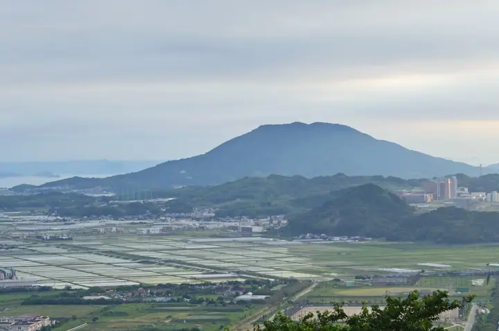
A 365-meter conical, free-standing peak rising over Itoshima City, Fukuoka, also known as Itoshima Fuji or Chikushi Fuji. Built largely of granodiorite, the mountain preserves traces of volcanic activity from roughly three million years ago. Its high-quality granite has long been quarried and was used for the stone torii at Nikkō Tōshō-gū Shrine. Kaya Shrine, dedicated to Emperor Jimmu, stands on the summit, where an observation deck looks out across the Genkai Sea. Listed in the Nihon Hyaku Fuji, Furusato Fuji Hyaku, and other anthologies of notable peaks.
Mt. Kayazan at a glance
- Weather: The most settled day in the next 7 days is Sun, November 8: clear, gusts up to 9 m/s.
- Route: The shortest is Mount Kaya (Itoshima Fuji) Out-and-Back from the Moroyoshi Trailhead: about 2 h 37 min, 4.4 km, about 380 m of climbing.
Mt. Kayazan weather (hourly, 14 days)
Sunrise today 06:39, sunset 17:27
| Tue, 11/3 | Wed, 11/4 | Thu, 11/5 | Fri, 11/6 | Sat, 11/7 | Sun, 11/8 | Mon, 11/9 | Tue, 11/10 | Wed, 11/11 | Thu, 11/12 | Fri, 11/13 | Sat, 11/14 | Sun, 11/15 | Mon, 11/16 | Tue, 11/17 | |||||||||||||||||||||||||||||||||||||||||||||||||||||||||||||||||||||||
|---|---|---|---|---|---|---|---|---|---|---|---|---|---|---|---|---|---|---|---|---|---|---|---|---|---|---|---|---|---|---|---|---|---|---|---|---|---|---|---|---|---|---|---|---|---|---|---|---|---|---|---|---|---|---|---|---|---|---|---|---|---|---|---|---|---|---|---|---|---|---|---|---|---|---|---|---|---|---|---|---|---|---|---|---|---|
| Japan time | 15 | 17 | 19 | 21 | 23 | 1 | 3 | 5 | 7 | 9 | 11 | 13 | 15 | 18 | 21 | 0 | 3 | 6 | 9 | 12 | 15 | 18 | 21 | 0 | 3 | 6 | 9 | 12 | 15 | 18 | 21 | 0 | 3 | 6 | 9 | 12 | 15 | 18 | 21 | 0 | 3 | 6 | 9 | 12 | 15 | 18 | 21 | 0 | 3 | 6 | 9 | 15 | 21 | 3 | 9 | 15 | 21 | 3 | 9 | 15 | 21 | 3 | 9 | 15 | 21 | 3 | 9 | 15 | 21 | 3 | 9 | 15 | 21 | 3 | 9 | 15 | 21 | 3 | 9 | 15 | 21 | 3 | 9 | 15 | |
  | |   | | | | |   |   |   | | | |   | | | | | |   | | |   |   | | | |  | |  | | | | | | | | | | | | | | | | | | | |   | |   | | | | | | | | |   | | | |  | | | | | | | | | | | | | | | | | | | | ||
| Temperature | °C | 15° | 14° | 14° | 14° | 13° | 13° | 12° | 12° | 11° | 12° | 15° | 17° | 17° | 14° | 13° | 14° | 14° | 13° | 17° | 18° | 17° | 17° | 16° | 14° | 14° | 14° | 15° | 15° | 13° | 11° | 11° | 9° | 8° | 8° | 9° | 10° | 10° | 8° | 7° | 6° | 7° | 8° | 10° | 13° | 12° | 11° | 11° | 11° | 11° | 10° | 12° | 13° | 10° | 9° | 11° | 12° | 12° | 9° | 10° | 11° | 8° | 6° | 11° | 13° | 8° | 9° | 13° | 15° | 11° | 8° | 12° | 16° | 12° | 11° | 13° | 16° | 15° | 14° | 14° | 15° | 12° | 10° | 11° | 13° |
| Precipitation | mm | 0.7 | 0.1 | 0.8 | 2.2 | 1.3 | 0.7 | 2.9 | 1.4 | 0.5 | 0.4 | 0.2 | 0.3 | 0.4 | 0.3 | 1.1 | 4.0 | 14 | 3.1 | 2.0 | 2.6 | 0.1 | 0.9 | 0.2 | |||||||||||||||||||||||||||||||||||||||||||||||||||||||||||||
| New snow | cm | ||||||||||||||||||||||||||||||||||||||||||||||||||||||||||||||||||||||||||||||||||||
| Snow depth | cm | 0 | 0 | 0 | 0 | 0 | 0 | 0 | 0 | 0 | 0 | 0 | 0 | 0 | 0 | 0 | 0 | 0 | 0 | 0 | 0 | 0 | 0 | 0 | 0 | 0 | 0 | 0 | 0 | 0 | 0 | 0 | 0 | 0 | 0 | 0 | 0 | 0 | 0 | 0 | 0 | 0 | 0 | 0 | 0 | 0 | 0 | 0 | 0 | 0 | 0 | 0 | 0 | 0 | 0 | 0 | 0 | 0 | 0 | 0 | 0 | 0 | 0 | 0 | 0 | 0 | 0 | 0 | 0 | 0 | 0 | 0 | 0 | 0 | 0 | 0 | 0 | 0 | 0 | 0 | 0 | 0 | 0 | 0 | 0 |
| Wind | m/s | 5 | 4 | 4 | 4 | 4 | 4 | 4 | 5 | 4 | 4 | 4 | 3 | 4 | 4 | 2 | 1 | 2 | 1 | 1 | 3 | 4 | 6 | 3 | 4 | 4 | 4 | 5 | 6 | 5 | 4 | 5 | 6 | 6 | 6 | 5 | 5 | 4 | 2 | 2 | 2 | 3 | 3 | 3 | 4 | 3 | 3 | 2 | 1 | 2 | 2 | 2 | 4 | 2 | 2 | 3 | 5 | 4 | 6 | 5 | 4 | 1 | 1 | 2 | 2 | 1 | 2 | 1 | 4 | 4 | 2 | 1 | 2 | 2 | 2 | 1 | 3 | 2 | 4 | 4 | 5 | 7 | 5 | 5 | 5 |
| Wind gusts | m/s | 13 | 11 | 9 | 9 | 9 | 9 | 8 | 9 | 9 | 8 | 10 | 10 | 9 | 9 | 7 | 4 | 4 | 4 | 6 | 8 | 14 | 13 | 13 | 8 | 9 | 9 | 10 | 14 | 14 | 12 | 11 | 14 | 14 | 13 | 13 | 12 | 11 | 9 | 4 | 4 | 6 | 7 | 7 | 9 | 9 | 7 | 6 | 3 | 5 | 4 | 5 | 10 | 9 | 5 | 8 | 12 | 11 | 13 | 12 | 11 | 9 | 3 | 5 | 6 | 6 | 3 | 4 | 9 | 9 | 8 | 5 | 7 | 6 | 5 | 6 | 9 | 10 | 8 | 9 | 12 | 14 | 14 | 11 | 11 |
| Wind dir. | ↓ | ↓ | ↓ | ↓ | ↓ | ↓ | ↓ | ↓ | ↓ | ↓ | ↓ | ↓ | ↓ | ↓ | ↓ | ↓ | ↓ | ↓ | ↓ | ↓ | ↓ | ↓ | ↓ | ↓ | ↓ | ↓ | ↓ | ↓ | ↓ | ↓ | ↓ | ↓ | ↓ | ↓ | ↓ | ↓ | ↓ | ↓ | ↓ | ↓ | ↓ | ↓ | ↓ | ↓ | ↓ | ↓ | ↓ | ↓ | ↓ | ↓ | ↓ | ↓ | ↓ | ↓ | ↓ | ↓ | ↓ | ↓ | ↓ | ↓ | ↓ | ↓ | ↓ | ↓ | ↓ | ↓ | ↓ | ↓ | ↓ | ↓ | ↓ | ↓ | ↓ | ↓ | ↓ | ↓ | ↓ | ↓ | ↓ | ↓ | ↓ | ↓ | ↓ | ↓ | |
Mt. Kayazan hiking routes
Hiking times are estimates calculated from the terrain.
Huts, campsites and lodging near Mt. Kayazan
Lodging
- bbb haus
- Guesthouse Kotonoha
- S&K ITOSHIMA
Lists that include Mt. Kayazan
Mt. Kayazan facts
- Also known as
- 糸島富士 筑紫富士
- Elevation
- 365 m
- Location
- Itoshima, Fukuoka
33.572267, 130.161054 - Website
- kanko-itoshima.jp
- Trail Map
- kanko-itoshima.jp (PDF)
- Wikipedia
- ja.wikipedia.org