
Mt. Oto
大戸岳
Shimogō-machi, Fukushima / Aizuwakamatsu, Fukushima · Elevation 1,416 m
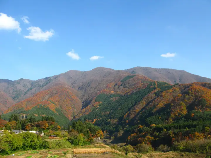
Mt. Oto is a 1,416-meter peak on the border between Oto-machi in Aizuwakamatsu City and Shimogo Town in Minami-Aizu District, Fukushima Prefecture, and is the highest mountain within Aizuwakamatsu City. A first-class triangulation point sits at the summit, and the trail through cypress and Asunaro forests passes the fifth station before reaching the top. The Aizu Festival Association hosts an annual mountain-opening ceremony on the second Saturday of June. The peak appears on the Utsukushima 100 and Aizu 100 Famous Mountains.
Mt. Oto at a glance
- Weather: The most settled day in the next 7 days is Wed, November 4: clear, gusts up to 8 m/s. Fri, Nov 6, Sat, Nov 7, Sun, Nov 8: strong wind (gusts up to 21 m/s).
Mt. Oto weather (hourly, 14 days)
Sunrise today 06:06, sunset 16:42
| Tue, 11/3 | Wed, 11/4 | Thu, 11/5 | Fri, 11/6 | Sat, 11/7 | Sun, 11/8 | Mon, 11/9 | Tue, 11/10 | Wed, 11/11 | Thu, 11/12 | Fri, 11/13 | Sat, 11/14 | Sun, 11/15 | Mon, 11/16 | Tue, 11/17 | |||||||||||||||||||||||||||||||||||||||||||||||||||||||||||||||||||||||
|---|---|---|---|---|---|---|---|---|---|---|---|---|---|---|---|---|---|---|---|---|---|---|---|---|---|---|---|---|---|---|---|---|---|---|---|---|---|---|---|---|---|---|---|---|---|---|---|---|---|---|---|---|---|---|---|---|---|---|---|---|---|---|---|---|---|---|---|---|---|---|---|---|---|---|---|---|---|---|---|---|---|---|---|---|---|
| Japan time | 15 | 17 | 19 | 21 | 23 | 1 | 3 | 5 | 7 | 9 | 11 | 13 | 15 | 18 | 21 | 0 | 3 | 6 | 9 | 12 | 15 | 18 | 21 | 0 | 3 | 6 | 9 | 12 | 15 | 18 | 21 | 0 | 3 | 6 | 9 | 12 | 15 | 18 | 21 | 0 | 3 | 6 | 9 | 12 | 15 | 18 | 21 | 0 | 3 | 6 | 9 | 15 | 21 | 3 | 9 | 15 | 21 | 3 | 9 | 15 | 21 | 3 | 9 | 15 | 21 | 3 | 9 | 15 | 21 | 3 | 9 | 15 | 21 | 3 | 9 | 15 | 21 | 3 | 9 | 15 | 21 | 3 | 9 | 15 | |
  |   |  | | | | | |   |  | | | | |   |   | | |   | |   |   | | | | | |   |   | | | | | |   | | |   | | | | | | | | | | | | | | | |   | | | | |   | |   | | | |  | | | | | | | | | | | | | | | | |   | | | ||
| Temperature | °C | 5° | 2° | 0° | -1° | -2° | -2° | -3° | -3° | -1° | 4° | 7° | 9° | 8° | 3° | 2° | 2° | 2° | 3° | 5° | 8° | 9° | 5° | 4° | 5° | 3° | 4° | 8° | 9° | 9° | 5° | 3° | 1° | 0° | -1° | -2° | -1° | -1° | -2° | -2° | -2° | -2° | -2° | 0° | 2° | 0° | -1° | -2° | -1° | -2° | -2° | -1° | 3° | -2° | -4° | 2° | 4° | -1° | -2° | -1° | 0° | -2° | -2° | 0° | 3° | -3° | -1° | 0° | 0° | -3° | -3° | 0° | 5° | -4° | -3° | 6° | 8° | 3° | 3° | 7° | 3° | -2° | -4° | -1° | 2° |
| Precipitation | mm | 3.3 | 7 | 9 | 8 | 2.1 | 0.2 | 1.7 | 0.5 | 0.4 | 1.2 | 1.1 | 0.8 | 2.1 | 2.8 | 1.9 | 1.6 | 0.8 | 0.5 | 0.3 | 0.3 | 0.2 | 0.3 | 0.2 | 0.2 | 0.6 | 0.4 | 0.1 | 1.1 | 1.3 | 2.2 | 0.3 | 0.1 | 0.6 | 2.4 | 3.0 | 9 | 3.3 | 1.9 | 0.3 | |||||||||||||||||||||||||||||||||||||||||||||
| New snow | cm | <.1 | 0.1 | <.1 | <.1 | 0.2 | <.1 | ||||||||||||||||||||||||||||||||||||||||||||||||||||||||||||||||||||||||||||||
| Snow depth | cm | 0 | 0 | 0 | 0 | 0 | 0 | 0 | 0 | 0 | 0 | 0 | 0 | 0 | 0 | 0 | 0 | 0 | 0 | 0 | 0 | 0 | 0 | 0 | 0 | 0 | 0 | 0 | 0 | 0 | 0 | 0 | 0 | 0 | 0 | 0 | 0 | 0 | 0 | 0 | 0 | 0 | 0 | 0 | 0 | 0 | 0 | 0 | 0 | 0 | 0 | 0 | 0 | 0 | 0 | 0 | 0 | 0 | 0 | 0 | 0 | 0 | 0 | 0 | 0 | 0 | 0 | 0 | 0 | 0 | 0 | 0 | 0 | 0 | 0 | 0 | 0 | 0 | 0 | 0 | 0 | 0 | 0 | 0 | 0 |
| Wind | m/s | 5 | 3 | 2 | 2 | 2 | 2 | 1 | 1 | 1 | 1 | 1 | 1 | 3 | 3 | 2 | 3 | 2 | 2 | 3 | 1 | 2 | 2 | 1 | 1 | 1 | 2 | 5 | 7 | 6 | 4 | 4 | 5 | 5 | 5 | 5 | 6 | 6 | 6 | 5 | 6 | 6 | 5 | 6 | 7 | 6 | 4 | 2 | 2 | 2 | 2 | 1 | 3 | 1 | 1 | 1 | 5 | 2 | 5 | 6 | 7 | 4 | 3 | 4 | 4 | 1 | 2 | 6 | 7 | 5 | 3 | 3 | 1 | 1 | 1 | 1 | 2 | 1 | 1 | 2 | 7 | 7 | 5 | 4 | 2 |
| Wind gusts | m/s | 15 | 13 | 8 | 7 | 6 | 6 | 5 | 5 | 4 | 5 | 5 | 5 | 8 | 9 | 8 | 9 | 9 | 6 | 11 | 9 | 6 | 4 | 4 | 4 | 4 | 7 | 13 | 19 | 17 | 14 | 13 | 13 | 14 | 15 | 15 | 20 | 21 | 18 | 15 | 16 | 15 | 16 | 15 | 18 | 18 | 16 | 10 | 7 | 6 | 6 | 5 | 8 | 9 | 5 | 4 | 13 | 13 | 14 | 17 | 23 | 19 | 11 | 10 | 12 | 11 | 7 | 15 | 19 | 18 | 12 | 8 | 8 | 5 | 4 | 3 | 5 | 4 | 6 | 7 | 18 | 20 | 18 | 13 | 10 |
| Wind dir. | ↓ | ↓ | ↓ | ↓ | ↓ | ↓ | ↓ | ↓ | ↓ | ↓ | ↓ | ↓ | ↓ | ↓ | ↓ | ↓ | ↓ | ↓ | ↓ | ↓ | ↓ | ↓ | ↓ | ↓ | ↓ | ↓ | ↓ | ↓ | ↓ | ↓ | ↓ | ↓ | ↓ | ↓ | ↓ | ↓ | ↓ | ↓ | ↓ | ↓ | ↓ | ↓ | ↓ | ↓ | ↓ | ↓ | ↓ | ↓ | ↓ | ↓ | ↓ | ↓ | ↓ | ↓ | ↓ | ↓ | ↓ | ↓ | ↓ | ↓ | ↓ | ↓ | ↓ | ↓ | ↓ | ↓ | ↓ | ↓ | ↓ | ↓ | ↓ | ↓ | ↓ | ↓ | ↓ | ↓ | ↓ | ↓ | ↓ | ↓ | ↓ | ↓ | ↓ | ↓ | |
Huts, campsites and lodging near Mt. Oto
Lodging
- 新湯
- 仙峡閣
- 不動館 小谷の湯
- 芦ノ牧ホテル
- 旅館 福泉
Lists that include Mt. Oto
Utsukushima 100 Famous Mountains (Fukushima Prefecture) · Aizu 100 Famous Mountains
Mt. Oto facts
- Elevation
- 1,416 m
- Location
- Shimogō-machi, Fukushima / Aizuwakamatsu, Fukushima
37.336751, 139.953278 - Website
- www.aizukanko.com
- Wikipedia
- ja.wikipedia.org