
Mt. Oritsumedake
折爪岳
Ninohe, Iwate · Elevation 852 m
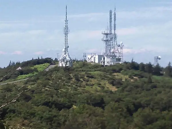
Mt. Oritsumedake is an 852-meter peak straddling Ninohe City, Karumai Town in Kunohe District, and Kunohe Village in Iwate Prefecture, with its summit on the boundary between Ninohe City and Kunohe Village. The area is designated the Oritsume-Basenkyō Prefectural Natural Park; a summit observation tower commands a 360-degree panorama of Mt. Iwate, the Hakkōda range, Mt. Iwaki, and the night lights of Hachinohe. The slopes host roughly one million Himebotaru fireflies in early to mid-July — a phenomenon protected as a prefectural natural monument. Ninohe City operates the Mori-no-Manabi-sha visitor center, an auto-campground, and the Yama-no-ie lodge on the mountain, which is included in the Iwate Hyakumeizan list.
Mt. Oritsumedake at a glance
- Weather: The most settled day in the next 7 days is Wed, November 4: clear, gusts up to 9 m/s. Sat, Nov 7, Sun, Nov 8: strong wind (gusts up to 22 m/s).
Mt. Oritsumedake weather (hourly, 14 days)
Sunrise today 06:05, sunset 16:31
| Tue, 11/3 | Wed, 11/4 | Thu, 11/5 | Fri, 11/6 | Sat, 11/7 | Sun, 11/8 | Mon, 11/9 | Tue, 11/10 | Wed, 11/11 | Thu, 11/12 | Fri, 11/13 | Sat, 11/14 | Sun, 11/15 | Mon, 11/16 | Tue, 11/17 | |||||||||||||||||||||||||||||||||||||||||||||||||||||||||||||||||||||||
|---|---|---|---|---|---|---|---|---|---|---|---|---|---|---|---|---|---|---|---|---|---|---|---|---|---|---|---|---|---|---|---|---|---|---|---|---|---|---|---|---|---|---|---|---|---|---|---|---|---|---|---|---|---|---|---|---|---|---|---|---|---|---|---|---|---|---|---|---|---|---|---|---|---|---|---|---|---|---|---|---|---|---|---|---|---|
| Japan time | 15 | 17 | 19 | 21 | 23 | 1 | 3 | 5 | 7 | 9 | 11 | 13 | 15 | 18 | 21 | 0 | 3 | 6 | 9 | 12 | 15 | 18 | 21 | 0 | 3 | 6 | 9 | 12 | 15 | 18 | 21 | 0 | 3 | 6 | 9 | 12 | 15 | 18 | 21 | 0 | 3 | 6 | 9 | 12 | 15 | 18 | 21 | 0 | 3 | 6 | 9 | 15 | 21 | 3 | 9 | 15 | 21 | 3 | 9 | 15 | 21 | 3 | 9 | 15 | 21 | 3 | 9 | 15 | 21 | 3 | 9 | 15 | 21 | 3 | 9 | 15 | 21 | 3 | 9 | 15 | 21 | 3 | 9 | 15 | |
  |   |  | | | | |   |  | | | | |  | | | |   |   |   | |   | | |   | | |   | |   | | | | | |   | | |   |   | | |   | |   | | | | |   | | | | | | | | | |   | | | | | | | | | | | | |  | | | | | | | | |   | | | ||
| Temperature | °C | 7° | 4° | 1° | 1° | 0° | 1° | 2° | 2° | 3° | 8° | 10° | 11° | 10° | 3° | 0° | 2° | 4° | 8° | 8° | 8° | 9° | 8° | 8° | 8° | 8° | 7° | 11° | 12° | 11° | 7° | 4° | 2° | 1° | 0° | 1° | 3° | 1° | 0° | 0° | 0° | 0° | 0° | 2° | 3° | 3° | 1° | 0° | 0° | 0° | -1° | 2° | 2° | -2° | -4° | 1° | 2° | 2° | 2° | 1° | 1° | -1° | -3° | 3° | 5° | -1° | 1° | 1° | 2° | -3° | -5° | 2° | 5° | -3° | -3° | 5° | 9° | 5° | 4° | 6° | 3° | -2° | -1° | 2° | 4° |
| Precipitation | mm | 1.7 | 3.3 | 2.2 | 3.3 | 0.4 | 1.6 | 1.9 | 1.0 | 0.6 | 0.1 | 0.2 | 0.3 | 0.7 | 0.5 | 0.3 | 0.3 | 0.2 | 0.2 | 0.2 | 7 | 14 | 11 | 0.9 | 0.8 | 0.2 | 0.4 | 0.3 | 1.4 | 1.0 | |||||||||||||||||||||||||||||||||||||||||||||||||||||||
| New snow | cm | <.1 | <.1 | <.1 | <.1 | <.1 | 0.6 | <.1 | |||||||||||||||||||||||||||||||||||||||||||||||||||||||||||||||||||||||||||||
| Snow depth | cm | 0 | 0 | 0 | 0 | 0 | 0 | 0 | 0 | 0 | 0 | 0 | 0 | 0 | 0 | 0 | 0 | 0 | 0 | 0 | 0 | 0 | 0 | 0 | 0 | 0 | 0 | 0 | 0 | 0 | 0 | 0 | 0 | 0 | 0 | 0 | 0 | 0 | 0 | 0 | 0 | 0 | 0 | 0 | 0 | 0 | 0 | 0 | 0 | 0 | 0 | 0 | 0 | 0 | 0 | 0 | 0 | 0 | 0 | 0 | 0 | 0 | 0 | 0 | 0 | 0 | 0 | 0 | 0 | 0 | 0 | 0 | 0 | 0 | 0 | 0 | 0 | 0 | 0 | 0 | 0 | 0 | 0 | 0 | 0 |
| Wind | m/s | 6 | 3 | 2 | 2 | 2 | 4 | 4 | 3 | 2 | 3 | 4 | 3 | 2 | 1 | 2 | 2 | 2 | 5 | 6 | 4 | 2 | 1 | 1 | 1 | 2 | 2 | 2 | 4 | 6 | 6 | 7 | 6 | 6 | 6 | 7 | 9 | 8 | 7 | 7 | 6 | 6 | 6 | 9 | 10 | 8 | 3 | 2 | 2 | 2 | 2 | 4 | 4 | 2 | 2 | 0 | 5 | 4 | 2 | 7 | 4 | 1 | 2 | 3 | 4 | 2 | 1 | 5 | 6 | 1 | 2 | 1 | 3 | 1 | 3 | 2 | 3 | 4 | 3 | 1 | 5 | 4 | 2 | 3 | 4 |
| Wind gusts | m/s | 15 | 14 | 8 | 6 | 6 | 9 | 10 | 9 | 7 | 8 | 9 | 9 | 8 | 5 | 5 | 6 | 6 | 11 | 14 | 14 | 9 | 3 | 4 | 4 | 6 | 5 | 6 | 13 | 14 | 15 | 16 | 16 | 14 | 15 | 16 | 22 | 20 | 18 | 16 | 16 | 14 | 15 | 19 | 22 | 22 | 18 | 8 | 5 | 5 | 6 | 10 | 11 | 9 | 5 | 4 | 12 | 12 | 10 | 16 | 16 | 8 | 5 | 8 | 13 | 10 | 5 | 12 | 14 | 12 | 4 | 5 | 9 | 7 | 6 | 7 | 7 | 8 | 10 | 6 | 12 | 12 | 9 | 7 | 11 |
| Wind dir. | ↓ | ↓ | ↓ | ↓ | ↓ | ↓ | ↓ | ↓ | ↓ | ↓ | ↓ | ↓ | ↓ | ↓ | ↓ | ↓ | ↓ | ↓ | ↓ | ↓ | ↓ | ↓ | ↓ | ↓ | ↓ | ↓ | ↓ | ↓ | ↓ | ↓ | ↓ | ↓ | ↓ | ↓ | ↓ | ↓ | ↓ | ↓ | ↓ | ↓ | ↓ | ↓ | ↓ | ↓ | ↓ | ↓ | ↓ | ↓ | ↓ | ↓ | ↓ | ↓ | ↓ | ↓ | ↓ | ↓ | ↓ | ↓ | ↓ | ↓ | ↓ | ↓ | ↓ | ↓ | ↓ | ↓ | ↓ | ↓ | ↓ | ↓ | ↓ | ↓ | ↓ | ↓ | ↓ | ↓ | ↓ | ↓ | ↓ | ↓ | ↓ | ↓ | ↓ | ↓ | |
Huts, campsites and lodging near Mt. Oritsumedake
Mountain huts
Campsites
- 折爪岳オートキャンプ場
- ミレットパーク
- ぼくらの森の家キャンプ場
Lists that include Mt. Oritsumedake
Iwate 100 Famous Mountains · Elevations of 1003 Mountains of Japan · 1000 Mountains of Japan
Mt. Oritsumedake facts
- Elevation
- 852 m
- Location
- Ninohe, Iwate
40.268794, 141.374468 - Website
- oritsumedake.com
- Trail Map
- oritsumedake.com
- Wikipedia
- ja.wikipedia.org