
Mt. Mokotoyama
藻琴山
Bihoro, Hokkaido / Ozora, Hokkaido / Teshikaga, Hokkaido / Koshimizu, Hokkaido · Elevation 1,000 m
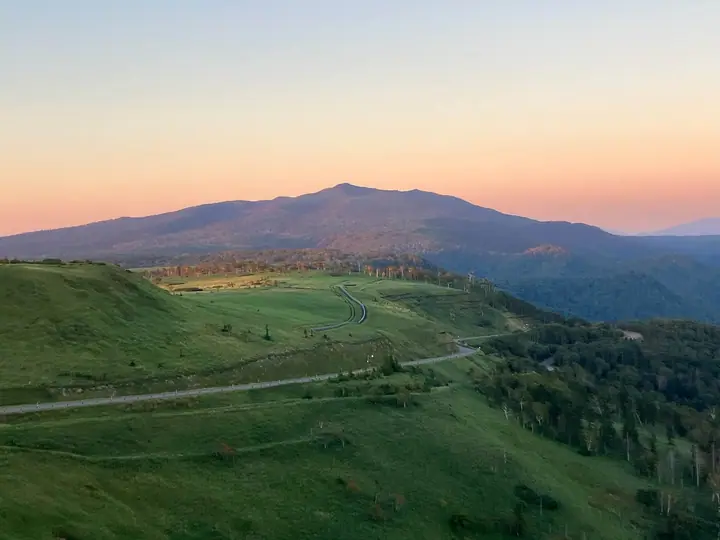
Mt. Mokotoyama is a 1,000-meter peak straddling Koshimizu Town in Shari District, Ōzora Town in Abashiri District, and Teshikaga Town in Kawakami District, Hokkaido — the highest summit on the Kussharo Caldera rim within Akan-Mashū National Park. A roughly 2 km trail of about an hour starts from Highland Koshimizu 725 (a 725-meter rest house on National Route 391), while a shorter 30-minute route ascends the eastern Higashi-Mokoto side; the summit looks down on Lake Kussharo and across to the Shiretoko Range and the Sea of Okhotsk. It is included in the Hokkaido Hyakumeizan list.
Mt. Mokotoyama at a glance
- Weather: The most settled day in the next 7 days is Mon, November 9: clear, gusts up to 10 m/s. Wed, Nov 4, Sat, Nov 7, Sun, Nov 8: strong wind (gusts up to 19 m/s).
- Route: The shortest is Mount Mokoto via the Skyline Trail: about 2 h 28 min, 4.1 km, about 340 m of climbing.
Mt. Mokotoyama weather (hourly, 14 days)
Sunrise today 06:00, sunset 16:13
| Tue, 11/3 | Wed, 11/4 | Thu, 11/5 | Fri, 11/6 | Sat, 11/7 | Sun, 11/8 | Mon, 11/9 | Tue, 11/10 | Wed, 11/11 | Thu, 11/12 | Fri, 11/13 | Sat, 11/14 | Sun, 11/15 | Mon, 11/16 | Tue, 11/17 | |||||||||||||||||||||||||||||||||||||||||||||||||||||||||||||||||||||||
|---|---|---|---|---|---|---|---|---|---|---|---|---|---|---|---|---|---|---|---|---|---|---|---|---|---|---|---|---|---|---|---|---|---|---|---|---|---|---|---|---|---|---|---|---|---|---|---|---|---|---|---|---|---|---|---|---|---|---|---|---|---|---|---|---|---|---|---|---|---|---|---|---|---|---|---|---|---|---|---|---|---|---|---|---|---|
| Japan time | 15 | 17 | 19 | 21 | 23 | 1 | 3 | 5 | 7 | 9 | 11 | 13 | 15 | 18 | 21 | 0 | 3 | 6 | 9 | 12 | 15 | 18 | 21 | 0 | 3 | 6 | 9 | 12 | 15 | 18 | 21 | 0 | 3 | 6 | 9 | 12 | 15 | 18 | 21 | 0 | 3 | 6 | 9 | 12 | 15 | 18 | 21 | 0 | 3 | 6 | 9 | 15 | 21 | 3 | 9 | 15 | 21 | 3 | 9 | 15 | 21 | 3 | 9 | 15 | 21 | 3 | 9 | 15 | 21 | 3 | 9 | 15 | 21 | 3 | 9 | 15 | 21 | 3 | 9 | 15 | 21 | 3 | 9 | 15 | |
  |  | | | |   |   | |   | |   |   |  |  | | | | | | | |   |   | | | |   | | | |   | | | | | | | | | | | | | | | | | | | | | | |   | | | | |   | | | |   | |   | | |   |   | | | |  | | | | | | |   |   | | | | ||
| Temperature | °C | 0° | -4° | -5° | -5° | -5° | -5° | -3° | -2° | -1° | 2° | 2° | 2° | 2° | -3° | -3° | -4° | -3° | -3° | 5° | 8° | 6° | 5° | 4° | 4° | 5° | 5° | 5° | 6° | 6° | 5° | 4° | 1° | -1° | -4° | -1° | 1° | -1° | -4° | -4° | -4° | -5° | -4° | -2° | -1° | -2° | -3° | -4° | -5° | -6° | -8° | -3° | -1° | -6° | -7° | -4° | -2° | -7° | -5° | -3° | -1° | -6° | -6° | -2° | 0° | -3° | -5° | -5° | -4° | -5° | -5° | -3° | -2° | -6° | -5° | 1° | 3° | 1° | 1° | 0° | -2° | -4° | -5° | -3° | -2° |
| Precipitation | mm | 0.1 | 0.2 | 5 | 1.9 | 2.2 | 0.2 | 0.6 | 0.1 | 0.2 | 0.1 | 0.3 | 0.1 | 0.1 | 0.9 | 1.7 | 4.7 | 2.3 | 1.6 | ||||||||||||||||||||||||||||||||||||||||||||||||||||||||||||||||||
| New snow | cm | 0.2 | 0.1 | <.1 | <.1 | 0.1 | 0.1 | 0.9 | <.1 | 0.1 | 0.6 | 1.6 | |||||||||||||||||||||||||||||||||||||||||||||||||||||||||||||||||||||||||
| Snow depth | cm | 0 | 0 | 0 | 0 | 0 | 0 | 0 | 0 | 0 | 0 | 0 | 0 | 0 | 0 | 0 | 0 | 0 | 0 | 0 | 0 | 0 | 0 | 0 | 0 | 0 | 0 | 0 | 0 | 0 | 0 | 0 | 0 | 0 | 0 | 0 | 0 | 0 | 0 | 0 | 0 | 0 | 0 | 0 | 0 | 0 | 0 | 0 | 0 | 0 | 0 | 0 | 0 | 0 | 0 | 0 | 0 | 0 | 0 | 0 | 0 | 0 | 0 | 0 | 0 | 0 | 0 | 0 | 0 | <1 | <1 | <1 | <1 | <1 | <1 | <1 | <1 | 0 | 0 | 0 | 0 | <1 | 1 | 1 | 1 |
| Wind | m/s | 4 | 2 | 1 | 2 | 1 | 2 | 3 | 4 | 3 | 6 | 7 | 5 | 3 | 1 | 2 | 2 | 3 | 3 | 3 | 4 | 4 | 3 | 2 | 3 | 2 | 3 | 4 | 4 | 4 | 4 | 2 | 5 | 5 | 3 | 5 | 7 | 5 | 3 | 1 | 1 | 2 | 5 | 7 | 8 | 7 | 5 | 3 | 2 | 0 | 1 | 2 | 3 | 1 | 1 | 1 | 3 | 1 | 0 | 0 | 2 | 1 | 1 | 1 | 1 | 2 | 3 | 5 | 6 | 4 | 5 | 4 | 3 | 1 | 2 | 3 | 3 | 3 | 3 | 3 | 4 | 5 | 4 | 5 | 2 |
| Wind gusts | m/s | 12 | 8 | 4 | 6 | 5 | 4 | 7 | 9 | 9 | 14 | 16 | 15 | 10 | 7 | 4 | 5 | 6 | 7 | 7 | 10 | 11 | 9 | 6 | 6 | 6 | 7 | 9 | 10 | 14 | 10 | 9 | 10 | 13 | 11 | 12 | 17 | 17 | 12 | 6 | 3 | 5 | 11 | 15 | 19 | 19 | 16 | 11 | 6 | 4 | 2 | 7 | 10 | 7 | 3 | 4 | 6 | 7 | 2 | 3 | 5 | 4 | 3 | 4 | 5 | 4 | 7 | 11 | 14 | 16 | 11 | 10 | 10 | 6 | 4 | 8 | 8 | 7 | 7 | 7 | 10 | 11 | 11 | 12 | 12 |
| Wind dir. | ↓ | ↓ | ↓ | ↓ | ↓ | ↓ | ↓ | ↓ | ↓ | ↓ | ↓ | ↓ | ↓ | ↓ | ↓ | ↓ | ↓ | ↓ | ↓ | ↓ | ↓ | ↓ | ↓ | ↓ | ↓ | ↓ | ↓ | ↓ | ↓ | ↓ | ↓ | ↓ | ↓ | ↓ | ↓ | ↓ | ↓ | ↓ | ↓ | ↓ | ↓ | ↓ | ↓ | ↓ | ↓ | ↓ | ↓ | ↓ | ↓ | ↓ | ↓ | ↓ | ↓ | ↓ | ↓ | ↓ | ↓ | ↓ | ↓ | ↓ | ↓ | ↓ | ↓ | ↓ | ↓ | ↓ | ↓ | ↓ | ↓ | ↓ | ↓ | ↓ | ↓ | ↓ | ↓ | ↓ | ↓ | ↓ | ↓ | ↓ | ↓ | ↓ | ↓ | ↓ | |
Mt. Mokotoyama hiking routes
Hiking times are estimates calculated from the terrain.
Huts, campsites and lodging near Mt. Mokotoyama
Mountain huts
Campsites
- ハイランド小清水キャンプ場
Lists that include Mt. Mokotoyama
Mt. Mokotoyama facts
- Elevation
- 1,000 m
- Location
- Bihoro, Hokkaido / Ozora, Hokkaido / Teshikaga, Hokkaido / Koshimizu, Hokkaido
43.704445, 144.331110 - National Park
- 阿寒摩周国立公園
- Website
- www.kawayu-eco-museum.com
- Access Information
- www.kawayu-eco-museum.com
- Wikipedia
- ja.wikipedia.org