
Mt. Kurosawa
黒沢山
Hamamatsu, Shizuoka · Elevation 2,123 m
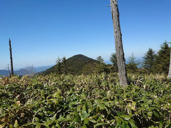
A 2,122.8-meter remote peak in the deep-southern Akaishi (Minami Alps) range, set in Misakubo, Tenryū Ward, Hamamatsu City, Shizuoka Prefecture. The mountain is locally nicknamed "Ma-no-yama" (the demon's mountain) for its dense bamboo thickets and fallen-timber bushwhacking — strictly an experienced climber's objective. The quiet summit sits within Shirabiso fir old-growth, and the standard route reaches it from a gate via a forest road, Okufu-yama and Shauzu-yama (1,835 m), with a saddle-crossing bushwhack to the top that requires over six hours round trip. Listed in Misakubo 100 and the 642 Peaks Above 2,000 m of Japan.
Mt. Kurosawa at a glance
- Weather: The most settled day in the next 7 days is Sun, November 8: clear, gusts up to 7 m/s. Fri, Nov 6, Sat, Nov 7: strong wind (gusts up to 21 m/s).
Mt. Kurosawa weather (hourly, 14 days)
Sunrise today 06:11, sunset 16:53
| Tue, 11/3 | Wed, 11/4 | Thu, 11/5 | Fri, 11/6 | Sat, 11/7 | Sun, 11/8 | Mon, 11/9 | Tue, 11/10 | Wed, 11/11 | Thu, 11/12 | Fri, 11/13 | Sat, 11/14 | Sun, 11/15 | Mon, 11/16 | Tue, 11/17 | |||||||||||||||||||||||||||||||||||||||||||||||||||||||||||||||||||||||
|---|---|---|---|---|---|---|---|---|---|---|---|---|---|---|---|---|---|---|---|---|---|---|---|---|---|---|---|---|---|---|---|---|---|---|---|---|---|---|---|---|---|---|---|---|---|---|---|---|---|---|---|---|---|---|---|---|---|---|---|---|---|---|---|---|---|---|---|---|---|---|---|---|---|---|---|---|---|---|---|---|---|---|---|---|---|
| Japan time | 21 | 23 | 1 | 3 | 5 | 7 | 9 | 11 | 13 | 15 | 17 | 19 | 21 | 0 | 3 | 6 | 9 | 12 | 15 | 18 | 21 | 0 | 3 | 6 | 9 | 12 | 15 | 18 | 21 | 0 | 3 | 6 | 9 | 12 | 15 | 18 | 21 | 0 | 3 | 6 | 9 | 12 | 15 | 18 | 21 | 0 | 3 | 6 | 9 | 12 | 15 | 21 | 3 | 9 | 15 | 21 | 3 | 9 | 15 | 21 | 3 | 9 | 15 | 21 | 3 | 9 | 15 | 21 | 3 | 9 | 15 | 21 | 3 | 9 | 15 | 21 | 3 | 9 | 15 | 21 | 3 | 9 | 15 | 21 | |
  |   | | | |   | | |   | |   | | | | | |   | |   |   | | | | |  | | | |  | | | | | | | | | | | | | | | | | | | | |   | | |   | | | | | | |   | | | |  | | | | |   | | | | | | | | | | | | | | | | ||
| Temperature | °C | 2° | 0° | 0° | 1° | 1° | 4° | 6° | 7° | 6° | 6° | 4° | 4° | 4° | 4° | 5° | 5° | 9° | 11° | 9° | 7° | 6° | 4° | 5° | 5° | 8° | 10° | 7° | 2° | 0° | 0° | -1° | -3° | 2° | 4° | 3° | -3° | -4° | -4° | -3° | -1° | 2° | 5° | 5° | 1° | 2° | 3° | 3° | 3° | 4° | 7° | 7° | 0° | -2° | 3° | 3° | -1° | -4° | 0° | 4° | -4° | -4° | 1° | 3° | -3° | -4° | 4° | 6° | -2° | -2° | 2° | 4° | -1° | 0° | 5° | 4° | 4° | 4° | 8° | 8° | 1° | 1° | 1° | 2° | 1° |
| Precipitation | mm | 0.1 | 0.5 | 0.3 | 0.7 | 1.5 | 9 | 9 | 3.9 | 2.1 | 0.4 | 0.3 | 0.8 | 0.2 | 0.4 | 0.1 | 0.4 | 0.4 | 1.1 | 0.2 | 1.7 | 28 | 29 | 1.8 | 4.2 | 1.7 | 1.4 | 0.4 | |||||||||||||||||||||||||||||||||||||||||||||||||||||||||
| New snow | cm | ||||||||||||||||||||||||||||||||||||||||||||||||||||||||||||||||||||||||||||||||||||
| Snow depth | cm | 0 | 0 | 0 | 0 | 0 | 0 | 0 | 0 | 0 | 0 | 0 | 0 | 0 | 0 | 0 | 0 | 0 | 0 | 0 | 0 | 0 | 0 | 0 | 0 | 0 | 0 | 0 | 0 | 0 | 0 | 0 | 0 | 0 | 0 | 0 | 0 | 0 | 0 | 0 | 0 | 0 | 0 | 0 | 0 | 0 | 0 | 0 | 0 | 0 | 0 | 0 | 0 | 0 | 0 | 0 | 0 | 0 | 0 | 0 | 0 | 0 | 0 | 0 | 0 | 0 | 0 | 0 | 0 | 0 | 0 | 0 | 0 | 0 | 0 | 0 | 0 | 0 | 0 | 0 | 0 | 0 | 0 | 0 | 0 |
| Wind | m/s | 0 | 1 | 1 | 1 | 0 | 1 | 1 | 1 | 1 | 2 | 2 | 3 | 3 | 3 | 1 | 1 | 2 | 1 | 1 | 0 | 1 | 2 | 3 | 3 | 3 | 6 | 5 | 4 | 4 | 4 | 4 | 4 | 4 | 6 | 5 | 3 | 2 | 1 | 0 | 0 | 1 | 2 | 2 | 0 | 1 | 0 | 0 | 1 | 1 | 2 | 3 | 0 | 1 | 1 | 4 | 3 | 6 | 3 | 2 | 1 | 1 | 1 | 2 | 1 | 3 | 2 | 1 | 0 | 1 | 2 | 2 | 1 | 1 | 1 | 1 | 1 | 1 | 3 | 5 | 1 | 1 | 1 | 2 | 1 |
| Wind gusts | m/s | 3 | 3 | 3 | 3 | 3 | 2 | 4 | 5 | 5 | 6 | 8 | 9 | 11 | 15 | 12 | 7 | 7 | 7 | 7 | 5 | 6 | 10 | 14 | 16 | 14 | 20 | 20 | 20 | 17 | 17 | 17 | 18 | 18 | 21 | 21 | 16 | 11 | 7 | 6 | 5 | 5 | 7 | 7 | 7 | 6 | 6 | 5 | 6 | 7 | 10 | 12 | 9 | 4 | 6 | 13 | 12 | 23 | 25 | 15 | 8 | 4 | 6 | 9 | 7 | 12 | 12 | 9 | 5 | 5 | 6 | 9 | 8 | 6 | 6 | 9 | 11 | 11 | 14 | 20 | 17 | 5 | 5 | 8 | 7 |
| Wind dir. | ↓ | ↓ | ↓ | ↓ | ↓ | ↓ | ↓ | ↓ | ↓ | ↓ | ↓ | ↓ | ↓ | ↓ | ↓ | ↓ | ↓ | ↓ | ↓ | ↓ | ↓ | ↓ | ↓ | ↓ | ↓ | ↓ | ↓ | ↓ | ↓ | ↓ | ↓ | ↓ | ↓ | ↓ | ↓ | ↓ | ↓ | ↓ | ↓ | ↓ | ↓ | ↓ | ↓ | ↓ | ↓ | ↓ | ↓ | ↓ | ↓ | ↓ | ↓ | ↓ | ↓ | ↓ | ↓ | ↓ | ↓ | ↓ | ↓ | ↓ | ↓ | ↓ | ↓ | ↓ | ↓ | ↓ | ↓ | ↓ | ↓ | ↓ | ↓ | ↓ | ↓ | ↓ | ↓ | ↓ | ↓ | ↓ | ↓ | ↓ | ↓ | ↓ | ↓ | ↓ | |
Lists that include Mt. Kurosawa
Mt. Kurosawa facts
- Elevation
- 2,123 m
- Location
- Hamamatsu, Shizuoka
35.264455, 138.001338 - Website
- www.misakubo.net
- Trail Map
- www.misakubo.net (PDF)
- Wikipedia
- ja.wikipedia.org