
Mt. Kuroboushidake
黒法師岳
Kawanehon, Shizuoka / Hamamatsu, Shizuoka · Elevation 2,068 m
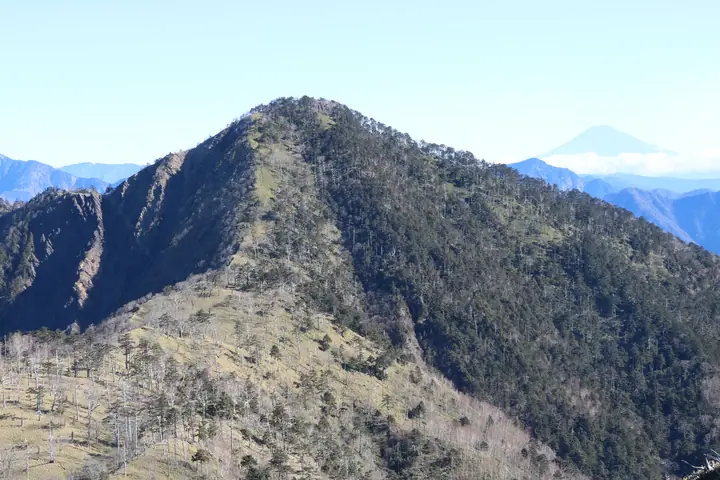
Kuroboushidake is a 2,068 m peak straddling the boundary between Tenryū Ward of Hamamatsu and Kawanehon-chō in Shizuoka Prefecture, in the deep southern section of the Akaishi Range (Southern Alps). Its summit holds an unusual first-order triangulation point engraved with an × mark instead of the customary + — believed to be the only such marker of its kind in Japan. It is the southernmost peak above 2,000 m named on official topographic maps and is included in both the Japanese 300 Famous Mountains and the Hundred First-Order Triangulation Mountains.
Mt. Kuroboushidake at a glance
- Weather: The most settled day in the next 7 days is Wed, November 4: cloudy, gusts up to 8 m/s. Fri, Nov 6, Sat, Nov 7: strong wind (gusts up to 19 m/s).
Mt. Kuroboushidake weather (hourly, 14 days)
Sunrise today 06:10, sunset 16:53
| Tue, 11/3 | Wed, 11/4 | Thu, 11/5 | Fri, 11/6 | Sat, 11/7 | Sun, 11/8 | Mon, 11/9 | Tue, 11/10 | Wed, 11/11 | Thu, 11/12 | Fri, 11/13 | Sat, 11/14 | Sun, 11/15 | Mon, 11/16 | Tue, 11/17 | |||||||||||||||||||||||||||||||||||||||||||||||||||||||||||||||||||||||
|---|---|---|---|---|---|---|---|---|---|---|---|---|---|---|---|---|---|---|---|---|---|---|---|---|---|---|---|---|---|---|---|---|---|---|---|---|---|---|---|---|---|---|---|---|---|---|---|---|---|---|---|---|---|---|---|---|---|---|---|---|---|---|---|---|---|---|---|---|---|---|---|---|---|---|---|---|---|---|---|---|---|---|---|---|---|
| Japan time | 15 | 17 | 19 | 21 | 23 | 1 | 3 | 5 | 7 | 9 | 11 | 13 | 15 | 18 | 21 | 0 | 3 | 6 | 9 | 12 | 15 | 18 | 21 | 0 | 3 | 6 | 9 | 12 | 15 | 18 | 21 | 0 | 3 | 6 | 9 | 12 | 15 | 18 | 21 | 0 | 3 | 6 | 9 | 12 | 15 | 18 | 21 | 0 | 3 | 6 | 9 | 15 | 21 | 3 | 9 | 15 | 21 | 3 | 9 | 15 | 21 | 3 | 9 | 15 | 21 | 3 | 9 | 15 | 21 | 3 | 9 | 15 | 21 | 3 | 9 | 15 | 21 | 3 | 9 | 15 | 21 | 3 | 9 | 15 | |
  |   | | |   | |   | |   | | | |   | | | | | | | | | | |   | |   |  | | |  | | | | | | | | | | | | |   |   | | | | | | | | | | | |   | | | | |   | | | |  | | | | |   | | | | | | | | | | | | | | | ||
| Temperature | °C | 7° | 4° | 4° | 4° | 3° | 2° | 0° | 1° | 3° | 5° | 9° | 8° | 8° | 5° | 6° | 5° | 6° | 6° | 9° | 13° | 9° | 8° | 7° | 4° | 5° | 6° | 10° | 13° | 10° | 6° | 4° | 2° | 1° | -1° | 4° | 6° | 5° | -1° | -3° | -3° | -3° | -3° | 4° | 7° | 6° | 2° | 1° | 2° | 2° | 0° | 5° | 8° | 2° | 0° | 4° | 6° | 0° | -2° | 2° | 6° | -3° | -4° | 2° | 4° | -1° | -4° | 5° | 6° | 0° | -1° | 3° | 5° | 0° | 2° | 6° | 5° | 4° | 5° | 9° | 11° | 2° | 3° | 3° | 4° |
| Precipitation | mm | 0.7 | 0.8 | 0.7 | 0.1 | 0.2 | 0.1 | 0.8 | 8 | 8 | 3.9 | 1.7 | 1.4 | 0.5 | 0.2 | 0.9 | 0.2 | 0.2 | 0.2 | 1.7 | 1.0 | 1.9 | 33 | 29 | 4.5 | 0.1 | 7 | 0.7 | 0.9 | ||||||||||||||||||||||||||||||||||||||||||||||||||||||||
| New snow | cm | ||||||||||||||||||||||||||||||||||||||||||||||||||||||||||||||||||||||||||||||||||||
| Snow depth | cm | 0 | 0 | 0 | 0 | 0 | 0 | 0 | 0 | 0 | 0 | 0 | 0 | 0 | 0 | 0 | 0 | 0 | 0 | 0 | 0 | 0 | 0 | 0 | 0 | 0 | 0 | 0 | 0 | 0 | 0 | 0 | 0 | 0 | 0 | 0 | 0 | 0 | 0 | 0 | 0 | 0 | 0 | 0 | 0 | 0 | 0 | 0 | 0 | 0 | 0 | 0 | 0 | 0 | 0 | 0 | 0 | 0 | 0 | 0 | 0 | 0 | 0 | 0 | 0 | 0 | 0 | 0 | 0 | 0 | 0 | 0 | 0 | 0 | 0 | 0 | 0 | 0 | 0 | 0 | 0 | 0 | 0 | 0 | 0 |
| Wind | m/s | 2 | 0 | 1 | 0 | 1 | 1 | 1 | 1 | 1 | 1 | 2 | 2 | 3 | 3 | 4 | 3 | 3 | 1 | 1 | 1 | 1 | 1 | 2 | 2 | 3 | 3 | 5 | 6 | 6 | 5 | 5 | 5 | 5 | 5 | 5 | 6 | 5 | 2 | 2 | 1 | 1 | 0 | 1 | 2 | 2 | 0 | 1 | 0 | 1 | 2 | 1 | 1 | 1 | 1 | 0 | 4 | 2 | 6 | 2 | 1 | 0 | 1 | 2 | 2 | 1 | 3 | 1 | 2 | 1 | 2 | 1 | 2 | 2 | 2 | 1 | 1 | 1 | 2 | 3 | 6 | 2 | 1 | 1 | 2 |
| Wind gusts | m/s | 9 | 7 | 3 | 3 | 3 | 3 | 4 | 3 | 3 | 5 | 6 | 7 | 8 | 10 | 12 | 13 | 12 | 10 | 6 | 6 | 8 | 8 | 6 | 8 | 11 | 13 | 15 | 18 | 18 | 18 | 18 | 18 | 18 | 18 | 18 | 18 | 19 | 15 | 8 | 6 | 5 | 5 | 4 | 7 | 9 | 7 | 3 | 3 | 4 | 6 | 6 | 11 | 7 | 4 | 4 | 11 | 11 | 19 | 22 | 10 | 5 | 4 | 6 | 7 | 7 | 10 | 11 | 8 | 7 | 6 | 6 | 10 | 8 | 6 | 6 | 7 | 8 | 10 | 11 | 19 | 17 | 7 | 5 | 8 |
| Wind dir. | ↓ | ↓ | ↓ | ↓ | ↓ | ↓ | ↓ | ↓ | ↓ | ↓ | ↓ | ↓ | ↓ | ↓ | ↓ | ↓ | ↓ | ↓ | ↓ | ↓ | ↓ | ↓ | ↓ | ↓ | ↓ | ↓ | ↓ | ↓ | ↓ | ↓ | ↓ | ↓ | ↓ | ↓ | ↓ | ↓ | ↓ | ↓ | ↓ | ↓ | ↓ | ↓ | ↓ | ↓ | ↓ | ↓ | ↓ | ↓ | ↓ | ↓ | ↓ | ↓ | ↓ | ↓ | ↓ | ↓ | ↓ | ↓ | ↓ | ↓ | ↓ | ↓ | ↓ | ↓ | ↓ | ↓ | ↓ | ↓ | ↓ | ↓ | ↓ | ↓ | ↓ | ↓ | ↓ | ↓ | ↓ | ↓ | ↓ | ↓ | ↓ | ↓ | ↓ | ↓ | |
Lists that include Mt. Kuroboushidake
Japan's 300 Famous Mountains · 100 Famous Mountains with First-order Triangulation Points · 100 Mountains of Shizuoka · 100 Mountains of Misakubo · Elevations of 1003 Mountains of Japan · 1000 Mountains of Japan
Mt. Kuroboushidake facts
- Elevation
- 2,068 m
- Location
- Kawanehon, Shizuoka / Hamamatsu, Shizuoka
35.196177, 138.029400 - Website
- www.misakubo.net
- Trail Map
- www.misakubo.net (PDF)
- Wikipedia
- ja.wikipedia.org