
Mt. Kōshasan
高社山
Kijimadaira, Nagano · Elevation 1,351 m
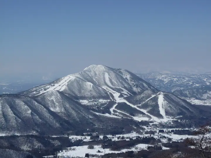
Mt. Kōshasan (locally also called Takayashiro-yama) is a 1,351 m stratovolcano straddling Nakano, Yamanouchi, and Kijimadaira in northern Nagano Prefecture, a free-standing summit on the edge of the Zenkōji Basin. Built of two-pyroxene andesite, its conical form has long earned it the nickname "Takai Fuji". Three trails — Kijimadaira on the north, Yomase on the south, and Tanigonji on the west — lead to the summit, and the peak appears in Shinshū Hyakumeizan, Nihon Hyakuteizan, Shinshū Furusato 120-zan, Furusato Fuji Hyaku, and Nihon Hyaku-Fuji.
Mt. Kōshasan at a glance
- Weather: The most settled day in the next 7 days is Wed, November 4: clear, gusts up to 7 m/s.
- Route: The shortest is Mount Kosha, the Takai Fuji, Return by the Thirteen-Buddhas Path from Kokugonji in Nakano: about 5 h 35 min, 8.4 km, about 970 m of climbing.
Mt. Kōshasan weather (hourly, 14 days)
Sunrise today 06:11, sunset 16:49
| Tue, 11/3 | Wed, 11/4 | Thu, 11/5 | Fri, 11/6 | Sat, 11/7 | Sun, 11/8 | Mon, 11/9 | Tue, 11/10 | Wed, 11/11 | Thu, 11/12 | Fri, 11/13 | Sat, 11/14 | Sun, 11/15 | Mon, 11/16 | Tue, 11/17 | |||||||||||||||||||||||||||||||||||||||||||||||||||||||||||||||||||||||
|---|---|---|---|---|---|---|---|---|---|---|---|---|---|---|---|---|---|---|---|---|---|---|---|---|---|---|---|---|---|---|---|---|---|---|---|---|---|---|---|---|---|---|---|---|---|---|---|---|---|---|---|---|---|---|---|---|---|---|---|---|---|---|---|---|---|---|---|---|---|---|---|---|---|---|---|---|---|---|---|---|---|---|---|---|---|
| Japan time | 15 | 17 | 19 | 21 | 23 | 1 | 3 | 5 | 7 | 9 | 11 | 13 | 15 | 18 | 21 | 0 | 3 | 6 | 9 | 12 | 15 | 18 | 21 | 0 | 3 | 6 | 9 | 12 | 15 | 18 | 21 | 0 | 3 | 6 | 9 | 12 | 15 | 18 | 21 | 0 | 3 | 6 | 9 | 12 | 15 | 18 | 21 | 0 | 3 | 6 | 9 | 15 | 21 | 3 | 9 | 15 | 21 | 3 | 9 | 15 | 21 | 3 | 9 | 15 | 21 | 3 | 9 | 15 | 21 | 3 | 9 | 15 | 21 | 3 | 9 | 15 | 21 | 3 | 9 | 15 | 21 | 3 | 9 | 15 | |
  |   |   | |  | | | |  | | |   | |   | |   | | |   | | | | | | |   | | | | | | | | |   |   | | | | | | | |   | | | | |   | | | | | | | | |   |   |   | | | | | | | | |   | | | |  | | | | |   | | | | | | | ||
| Temperature | °C | 6° | 3° | 0° | -1° | -1° | -1° | -1° | -1° | 0° | 7° | 9° | 11° | 10° | 6° | 5° | 5° | 5° | 6° | 9° | 12° | 12° | 9° | 9° | 8° | 8° | 5° | 11° | 13° | 12° | 6° | 5° | 3° | 2° | 1° | 2° | 4° | 3° | 0° | 0° | 0° | 0° | 0° | 2° | 3° | 2° | 0° | 0° | 1° | 1° | 2° | 4° | 4° | 1° | 1° | 5° | 8° | 1° | 0° | -3° | -1° | -1° | -1° | 1° | 3° | -3° | 0° | 0° | 0° | -1° | -4° | 3° | 7° | 1° | 1° | 7° | 9° | 4° | 6° | 8° | 4° | -1° | -2° | 1° | 4° |
| Precipitation | mm | 0.3 | 9 | 6 | 1.3 | 1.2 | 0.3 | 0.2 | 0.2 | 0.2 | 0.3 | 0.1 | 0.1 | 0.6 | 0.7 | 0.1 | 2.4 | 4.7 | 6 | 2.0 | 0.1 | 6 | 1.9 | 0.1 | 4.5 | 4.7 | 0.4 | 2.9 | 6 | 0.4 | |||||||||||||||||||||||||||||||||||||||||||||||||||||||
| New snow | cm | <.1 | <.1 | <.1 | <.1 | <.1 | 0.1 | <.1 | <.1 | 0.8 | 4.5 | 4.0 | 0.8 | <.1 | 2.1 | 0.9 | <.1 | 1.0 | 0.1 | ||||||||||||||||||||||||||||||||||||||||||||||||||||||||||||||||||
| Snow depth | cm | 0 | 0 | 0 | 0 | 0 | 0 | 0 | 0 | 0 | 0 | 0 | 0 | 0 | 0 | 0 | 0 | 0 | 0 | 0 | 0 | 0 | 0 | 0 | 0 | 0 | 0 | 0 | 0 | 0 | 0 | 0 | 0 | 0 | 0 | 0 | 0 | 0 | 0 | 0 | 0 | 0 | 0 | 0 | 0 | 0 | 0 | 0 | 0 | <1 | <1 | <1 | 0 | 0 | 0 | 0 | 0 | 0 | <1 | 4 | 5 | 5 | 4 | 4 | 3 | 3 | 2 | 4 | 4 | 4 | 4 | 4 | 3 | 3 | 3 | 3 | 2 | 2 | 1 | <1 | <1 | <1 | 1 | 1 | <1 |
| Wind | m/s | 3 | 2 | 1 | 1 | 1 | 1 | 1 | 1 | 1 | 1 | 1 | 1 | 1 | 3 | 3 | 3 | 2 | 2 | 2 | 2 | 1 | 0 | 0 | 1 | 0 | 1 | 1 | 2 | 2 | 1 | 2 | 3 | 2 | 3 | 4 | 4 | 4 | 3 | 3 | 2 | 4 | 3 | 3 | 4 | 4 | 1 | 1 | 0 | 0 | 1 | 1 | 3 | 1 | 0 | 2 | 3 | 2 | 2 | 3 | 4 | 2 | 1 | 0 | 3 | 2 | 0 | 2 | 4 | 2 | 1 | 1 | 2 | 1 | 1 | 2 | 0 | 2 | 2 | 1 | 4 | 4 | 2 | 1 | 2 |
| Wind gusts | m/s | 10 | 8 | 4 | 4 | 4 | 4 | 4 | 4 | 4 | 5 | 6 | 7 | 6 | 8 | 9 | 10 | 9 | 8 | 7 | 7 | 7 | 5 | 3 | 4 | 4 | 3 | 5 | 8 | 9 | 8 | 6 | 8 | 9 | 9 | 13 | 14 | 14 | 13 | 10 | 8 | 11 | 11 | 10 | 10 | 12 | 10 | 4 | 3 | 4 | 4 | 5 | 9 | 7 | 3 | 7 | 10 | 9 | 13 | 15 | 17 | 14 | 8 | 4 | 9 | 8 | 6 | 8 | 12 | 11 | 8 | 4 | 5 | 5 | 5 | 7 | 8 | 8 | 12 | 8 | 14 | 14 | 11 | 6 | 7 |
| Wind dir. | ↓ | ↓ | ↓ | ↓ | ↓ | ↓ | ↓ | ↓ | ↓ | ↓ | ↓ | ↓ | ↓ | ↓ | ↓ | ↓ | ↓ | ↓ | ↓ | ↓ | ↓ | ↓ | ↓ | ↓ | ↓ | ↓ | ↓ | ↓ | ↓ | ↓ | ↓ | ↓ | ↓ | ↓ | ↓ | ↓ | ↓ | ↓ | ↓ | ↓ | ↓ | ↓ | ↓ | ↓ | ↓ | ↓ | ↓ | ↓ | ↓ | ↓ | ↓ | ↓ | ↓ | ↓ | ↓ | ↓ | ↓ | ↓ | ↓ | ↓ | ↓ | ↓ | ↓ | ↓ | ↓ | ↓ | ↓ | ↓ | ↓ | ↓ | ↓ | ↓ | ↓ | ↓ | ↓ | ↓ | ↓ | ↓ | ↓ | ↓ | ↓ | ↓ | ↓ | ↓ | |
Mt. Kōshasan hiking routes
Hiking times are estimates calculated from the terrain.
Huts, campsites and lodging near Mt. Kōshasan
Mountain huts
Lodging
- Koshasanroku Miyukino mori
- ヴィラ・チェリオ
- ホテルホワイトイン北志賀
- ホテルシャレー竜王
- Hotel North Shiga
Lists that include Mt. Kōshasan
100 Low Mountains of Japan · 100 Fujis of Japan · Shinshu 100 Famous Mountains · Elevations of 1003 Mountains of Japan · 1000 Mountains of Japan
Mt. Kōshasan facts
- Also known as
- 高井富士 · たかやしろ
- Elevation
- 1,351 m
- Location
- Kijimadaira, Nagano
36.799350, 138.403793 - Website
- www.vill.kijimadaira.lg.jp
- Trail Map
- www.vill.kijimadaira.lg.jp (PDF)
- Access Information
- www.city.nakano.nagano.jp (PDF)
- Wikipedia
- ja.wikipedia.org