
Mt. Kizan
基山
Kiyama, Saga / Chikushino, Fukuoka · Elevation 404 m
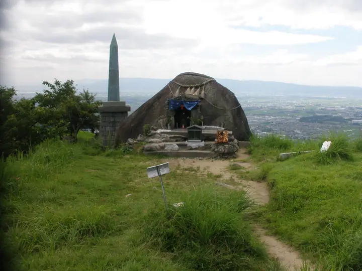
Mt. Kizan, 404.5 m, sits on the border of Kiyama Town in Saga Prefecture and Chikushino City in Fukuoka Prefecture at the eastern end of the Sefuri Range. Its summit and surrounds preserve the ancient mountain castle of Kiijō, built in 665 CE under Emperor Tenji to defend Dazaifu after Japan's defeat at the Battle of Baekgang; some 4 km of earthen and stone ramparts and a water-gate ruin remain, designated a national Special Historic Site. The grass-topped summit gives a broad panorama over Dazaifu, the Fukuoka Plain and the Ariake Sea, and Kiyama Town maintains a 90–120-minute loop accessed from JR Kizan or Keyakidai stations via the Hon'fukuji, Grass-Ski-Slope, and Watergate trails.
Mt. Kizan at a glance
- Weather: The most settled day in the next 7 days is Sun, November 8: clear, gusts up to 6 m/s.
- Route: The shortest is Kii Castle Ruins Loop from the Grass Ski Slope to the Summit of Mount Kizan: about 34 min, 976 m, about 80 m of climbing.
Mt. Kizan weather (hourly, 14 days)
Sunrise today 06:38, sunset 17:25
| Tue, 11/3 | Wed, 11/4 | Thu, 11/5 | Fri, 11/6 | Sat, 11/7 | Sun, 11/8 | Mon, 11/9 | Tue, 11/10 | Wed, 11/11 | Thu, 11/12 | Fri, 11/13 | Sat, 11/14 | Sun, 11/15 | Mon, 11/16 | Tue, 11/17 | |||||||||||||||||||||||||||||||||||||||||||||||||||||||||||||||||||||||
|---|---|---|---|---|---|---|---|---|---|---|---|---|---|---|---|---|---|---|---|---|---|---|---|---|---|---|---|---|---|---|---|---|---|---|---|---|---|---|---|---|---|---|---|---|---|---|---|---|---|---|---|---|---|---|---|---|---|---|---|---|---|---|---|---|---|---|---|---|---|---|---|---|---|---|---|---|---|---|---|---|---|---|---|---|---|
| Japan time | 15 | 17 | 19 | 21 | 23 | 1 | 3 | 5 | 7 | 9 | 11 | 13 | 15 | 18 | 21 | 0 | 3 | 6 | 9 | 12 | 15 | 18 | 21 | 0 | 3 | 6 | 9 | 12 | 15 | 18 | 21 | 0 | 3 | 6 | 9 | 12 | 15 | 18 | 21 | 0 | 3 | 6 | 9 | 12 | 15 | 18 | 21 | 0 | 3 | 6 | 9 | 15 | 21 | 3 | 9 | 15 | 21 | 3 | 9 | 15 | 21 | 3 | 9 | 15 | 21 | 3 | 9 | 15 | 21 | 3 | 9 | 15 | 21 | 3 | 9 | 15 | 21 | 3 | 9 | 15 | 21 | 3 | 9 | 15 | |
  |   |   |   | | | | | |   | | | |   | | | | | |   | |   |   | | |  | |  | | | | | | | | | | | | | | | | | | | | | | | |   | |   | | |   | |   | | |  | | | | | | | | | | | | | | | | | | | | | | | ||
| Temperature | °C | 16° | 14° | 12° | 11° | 10° | 10° | 9° | 10° | 9° | 12° | 16° | 18° | 17° | 13° | 13° | 13° | 13° | 13° | 15° | 17° | 18° | 16° | 15° | 14° | 14° | 11° | 15° | 16° | 13° | 10° | 9° | 8° | 6° | 6° | 9° | 11° | 11° | 7° | 5° | 4° | 3° | 4° | 10° | 12° | 13° | 10° | 9° | 9° | 8° | 8° | 12° | 14° | 7° | 6° | 10° | 12° | 8° | 7° | 9° | 11° | 5° | 3° | 8° | 13° | 5° | 4° | 10° | 14° | 8° | 5° | 10° | 16° | 10° | 11° | 12° | 14° | 13° | 13° | 14° | 16° | 10° | 9° | 10° | 14° |
| Precipitation | mm | 0.4 | 0.6 | 0.4 | 2.2 | 0.5 | 2.7 | 0.4 | 0.2 | 0.4 | 0.2 | 0.1 | 1.9 | 16 | 11 | 0.3 | 0.9 | 0.2 | |||||||||||||||||||||||||||||||||||||||||||||||||||||||||||||||||||
| New snow | cm | ||||||||||||||||||||||||||||||||||||||||||||||||||||||||||||||||||||||||||||||||||||
| Snow depth | cm | 0 | 0 | 0 | 0 | 0 | 0 | 0 | 0 | 0 | 0 | 0 | 0 | 0 | 0 | 0 | 0 | 0 | 0 | 0 | 0 | 0 | 0 | 0 | 0 | 0 | 0 | 0 | 0 | 0 | 0 | 0 | 0 | 0 | 0 | 0 | 0 | 0 | 0 | 0 | 0 | 0 | 0 | 0 | 0 | 0 | 0 | 0 | 0 | 0 | 0 | 0 | 0 | 0 | 0 | 0 | 0 | 0 | 0 | 0 | 0 | 0 | 0 | 0 | 0 | 0 | 0 | 0 | 0 | 0 | 0 | 0 | 0 | 0 | 0 | 0 | 0 | 0 | 0 | 0 | 0 | 0 | 0 | 0 | 0 |
| Wind | m/s | 3 | 3 | 2 | 2 | 2 | 2 | 2 | 2 | 2 | 2 | 3 | 2 | 3 | 2 | 1 | 1 | 1 | 1 | 2 | 3 | 4 | 2 | 2 | 2 | 4 | 3 | 4 | 5 | 5 | 3 | 3 | 4 | 4 | 4 | 4 | 4 | 4 | 2 | 1 | 1 | 1 | 1 | 1 | 2 | 2 | 1 | 1 | 1 | 1 | 2 | 1 | 4 | 1 | 1 | 1 | 5 | 0 | 3 | 3 | 4 | 0 | 0 | 1 | 3 | 1 | 0 | 0 | 3 | 2 | 1 | 1 | 2 | 1 | 1 | 3 | 3 | 0 | 1 | 3 | 4 | 3 | 3 | 3 | 3 |
| Wind gusts | m/s | 8 | 8 | 6 | 5 | 5 | 5 | 4 | 4 | 4 | 5 | 7 | 7 | 6 | 7 | 5 | 3 | 3 | 2 | 5 | 9 | 11 | 11 | 6 | 5 | 8 | 9 | 10 | 13 | 13 | 12 | 8 | 10 | 9 | 9 | 10 | 11 | 10 | 9 | 4 | 3 | 3 | 3 | 4 | 5 | 6 | 6 | 3 | 2 | 3 | 4 | 4 | 9 | 9 | 3 | 4 | 12 | 11 | 8 | 8 | 10 | 9 | 2 | 3 | 7 | 7 | 2 | 3 | 8 | 7 | 4 | 4 | 6 | 5 | 3 | 8 | 10 | 8 | 5 | 7 | 11 | 10 | 7 | 7 | 9 |
| Wind dir. | ↓ | ↓ | ↓ | ↓ | ↓ | ↓ | ↓ | ↓ | ↓ | ↓ | ↓ | ↓ | ↓ | ↓ | ↓ | ↓ | ↓ | ↓ | ↓ | ↓ | ↓ | ↓ | ↓ | ↓ | ↓ | ↓ | ↓ | ↓ | ↓ | ↓ | ↓ | ↓ | ↓ | ↓ | ↓ | ↓ | ↓ | ↓ | ↓ | ↓ | ↓ | ↓ | ↓ | ↓ | ↓ | ↓ | ↓ | ↓ | ↓ | ↓ | ↓ | ↓ | ↓ | ↓ | ↓ | ↓ | ↓ | ↓ | ↓ | ↓ | ↓ | ↓ | ↓ | ↓ | ↓ | ↓ | ↓ | ↓ | ↓ | ↓ | ↓ | ↓ | ↓ | ↓ | ↓ | ↓ | ↓ | ↓ | ↓ | ↓ | ↓ | ↓ | ↓ | ↓ | |
Mt. Kizan hiking routes
- Kii Castle Ruins Loop from the Grass Ski Slope to the Summit of Mount Kizan 976 m · Ascent 78 m
- Kii Castle Ruins, Return from the Haruda Side of Chikushino via the Otaki Shrine to the Summit of Mount Kizan 6.4 km · Ascent 374 m parking
Hiking times are estimates calculated from the terrain.
Huts, campsites and lodging near Mt. Kizan
Campsites
- 基山町キャンプ場
Lodging
- ホテルレミー
- ホテルシルクの森
Lists that include Mt. Kizan
Mt. Kizan facts
- Also known as
- きやま
- Elevation
- 404 m
- Location
- Kiyama, Saga / Chikushino, Fukuoka
33.442794, 130.509961 - Website
- www.town.kiyama.lg.jp
- Trail Map
- www.town.kiyama.lg.jp (PDF)
- Access Information
- www.town.kiyama.lg.jp
- Wikipedia
- ja.wikipedia.org