
Mt. Homanzan
宝満山
Chikushino, Fukuoka / Dazaifu, Fukuoka · Elevation 830 m
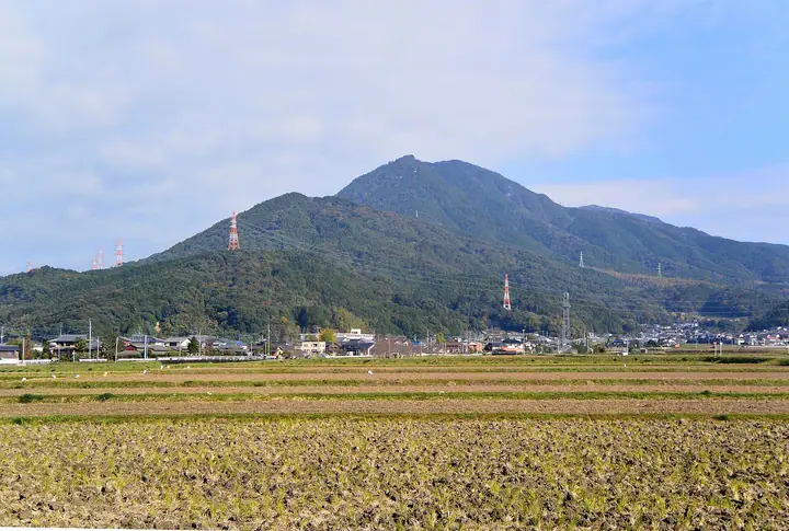
Mount Homanzan (829.6 m) is a granite peak on the border of Dazaifu and Chikushino in Fukuoka, also known as Kamado-yama or Mikasa-yama. Long revered as a sacred mountain where the gods descended to protect the ancient Dazaifu government, the peak hosted prayers for envoys to Tang-era China and grew into one of Kyushu's two great mountain-ascetic centres alongside Mount Hiko. The abundance of ritual sites, temple ruins and cave retreats led to its designation as a National Historic Site for mountain faith. It is included in the Kyushu 100 Mountains and Japan Low Sacred 100 selections.
Mt. Homanzan at a glance
- Weather: The most settled day in the next 7 days is Sun, November 8: clear, gusts up to 6 m/s.
- Route: The shortest is Kamado Shrine to Mount Homan via the Front Trail Return: about 3 h, 5.1 km, about 620 m of climbing.
Mt. Homanzan weather (hourly, 14 days)
Sunrise today 06:38, sunset 17:25
| Tue, 11/3 | Wed, 11/4 | Thu, 11/5 | Fri, 11/6 | Sat, 11/7 | Sun, 11/8 | Mon, 11/9 | Tue, 11/10 | Wed, 11/11 | Thu, 11/12 | Fri, 11/13 | Sat, 11/14 | Sun, 11/15 | Mon, 11/16 | Tue, 11/17 | |||||||||||||||||||||||||||||||||||||||||||||||||||||||||||||||||||||||
|---|---|---|---|---|---|---|---|---|---|---|---|---|---|---|---|---|---|---|---|---|---|---|---|---|---|---|---|---|---|---|---|---|---|---|---|---|---|---|---|---|---|---|---|---|---|---|---|---|---|---|---|---|---|---|---|---|---|---|---|---|---|---|---|---|---|---|---|---|---|---|---|---|---|---|---|---|---|---|---|---|---|---|---|---|---|
| Japan time | 15 | 17 | 19 | 21 | 23 | 1 | 3 | 5 | 7 | 9 | 11 | 13 | 15 | 18 | 21 | 0 | 3 | 6 | 9 | 12 | 15 | 18 | 21 | 0 | 3 | 6 | 9 | 12 | 15 | 18 | 21 | 0 | 3 | 6 | 9 | 12 | 15 | 18 | 21 | 0 | 3 | 6 | 9 | 12 | 15 | 18 | 21 | 0 | 3 | 6 | 9 | 15 | 21 | 3 | 9 | 15 | 21 | 3 | 9 | 15 | 21 | 3 | 9 | 15 | 21 | 3 | 9 | 15 | 21 | 3 | 9 | 15 | 21 | 3 | 9 | 15 | 21 | 3 | 9 | 15 | 21 | 3 | 9 | 15 | |
  |   |   |   | | | | | |   | | | |   | | | | | |   | |   |   | | | | |  | |  | | | | | | | | | | | | | | | | | | | | | |   | | | | |   | |   | |   |  | | | | | | | | | | | | | | | | | | | | | | | ||
| Temperature | °C | 14° | 12° | 10° | 9° | 8° | 8° | 8° | 7° | 6° | 10° | 14° | 16° | 14° | 11° | 11° | 11° | 11° | 10° | 14° | 14° | 16° | 14° | 13° | 12° | 11° | 10° | 13° | 14° | 11° | 8° | 7° | 6° | 4° | 4° | 7° | 9° | 9° | 5° | 4° | 2° | 2° | 2° | 8° | 10° | 11° | 8° | 7° | 6° | 6° | 7° | 10° | 12° | 6° | 5° | 9° | 10° | 8° | 5° | 7° | 9° | 4° | 1° | 7° | 11° | 4° | 4° | 9° | 13° | 6° | 3° | 7° | 15° | 8° | 9° | 10° | 12° | 11° | 11° | 12° | 13° | 8° | 7° | 9° | 12° |
| Precipitation | mm | 0.9 | 0.4 | 0.1 | 0.1 | 7 | 2.9 | 3.1 | 0.8 | 0.9 | 0.6 | 0.4 | 0.2 | 0.4 | 0.1 | 0.4 | 3.3 | 16 | 16 | 0.6 | 1.2 | 0.1 | |||||||||||||||||||||||||||||||||||||||||||||||||||||||||||||||
| New snow | cm | ||||||||||||||||||||||||||||||||||||||||||||||||||||||||||||||||||||||||||||||||||||
| Snow depth | cm | 0 | 0 | 0 | 0 | 0 | 0 | 0 | 0 | 0 | 0 | 0 | 0 | 0 | 0 | 0 | 0 | 0 | 0 | 0 | 0 | 0 | 0 | 0 | 0 | 0 | 0 | 0 | 0 | 0 | 0 | 0 | 0 | 0 | 0 | 0 | 0 | 0 | 0 | 0 | 0 | 0 | 0 | 0 | 0 | 0 | 0 | 0 | 0 | 0 | 0 | 0 | 0 | 0 | 0 | 0 | 0 | 0 | 0 | 0 | 0 | 0 | 0 | 0 | 0 | 0 | 0 | 0 | 0 | 0 | 0 | 0 | 0 | 0 | 0 | 0 | 0 | 0 | 0 | 0 | 0 | 0 | 0 | 0 | 0 |
| Wind | m/s | 3 | 2 | 1 | 1 | 1 | 1 | 1 | 1 | 1 | 2 | 3 | 3 | 3 | 2 | 1 | 2 | 1 | 1 | 1 | 3 | 4 | 2 | 2 | 2 | 3 | 3 | 5 | 5 | 5 | 3 | 3 | 4 | 3 | 3 | 4 | 4 | 3 | 1 | 0 | 0 | 1 | 1 | 1 | 2 | 2 | 1 | 0 | 0 | 0 | 1 | 0 | 3 | 1 | 0 | 2 | 5 | 1 | 2 | 3 | 3 | 0 | 1 | 1 | 3 | 0 | 1 | 0 | 3 | 1 | 1 | 1 | 2 | 1 | 1 | 1 | 2 | 1 | 2 | 3 | 4 | 3 | 2 | 2 | 3 |
| Wind gusts | m/s | 9 | 9 | 6 | 5 | 4 | 4 | 4 | 4 | 4 | 5 | 9 | 9 | 8 | 9 | 5 | 5 | 5 | 3 | 5 | 10 | 13 | 12 | 7 | 6 | 8 | 8 | 11 | 13 | 14 | 12 | 9 | 11 | 10 | 9 | 10 | 11 | 10 | 8 | 3 | 2 | 2 | 3 | 4 | 5 | 6 | 6 | 2 | 2 | 2 | 4 | 4 | 9 | 9 | 3 | 7 | 12 | 12 | 9 | 7 | 10 | 9 | 2 | 4 | 8 | 7 | 3 | 3 | 8 | 7 | 4 | 4 | 7 | 7 | 5 | 9 | 12 | 10 | 6 | 8 | 11 | 10 | 8 | 6 | 8 |
| Wind dir. | ↓ | ↓ | ↓ | ↓ | ↓ | ↓ | ↓ | ↓ | ↓ | ↓ | ↓ | ↓ | ↓ | ↓ | ↓ | ↓ | ↓ | ↓ | ↓ | ↓ | ↓ | ↓ | ↓ | ↓ | ↓ | ↓ | ↓ | ↓ | ↓ | ↓ | ↓ | ↓ | ↓ | ↓ | ↓ | ↓ | ↓ | ↓ | ↓ | ↓ | ↓ | ↓ | ↓ | ↓ | ↓ | ↓ | ↓ | ↓ | ↓ | ↓ | ↓ | ↓ | ↓ | ↓ | ↓ | ↓ | ↓ | ↓ | ↓ | ↓ | ↓ | ↓ | ↓ | ↓ | ↓ | ↓ | ↓ | ↓ | ↓ | ↓ | ↓ | ↓ | ↓ | ↓ | ↓ | ↓ | ↓ | ↓ | ↓ | ↓ | ↓ | ↓ | ↓ | ↓ | |
Mt. Homanzan hiking routes
- Kamado Shrine to Mount Homan via the Front Trail Return 5.1 km · Ascent 623 m parking
- Mount Hōman and Mount Bucchō Circuit via the Main Trail and Usagi Trail 7.3 km · Ascent 759 m かまど神社駐車場, 内山 (竈門神社前) (Bus stop) (parking)
- Dazaifu Tenmangu and Mount Homan Returns from Kamado Shrine 11.9 km · Ascent 864 m Kamado Jinja, 内山 (竈門神社前) (Bus stop), かまど神社駐車場
- Mount Homan, Mount Buccho and Mount Sangun Out-and-Back 11.1 km · Ascent 1,062 m かまど神社駐車場, 内山 (竈門神社前) (Bus stop) (parking)
Hiking times are estimates calculated from the terrain.
Huts, campsites and lodging near Mt. Homanzan
Campsites
- Houmanzan Camp Center
- 宇美町昭和の森キャンプ場
Lodging
- HOTEL CULTIA DAZAIFU
- HOTEL CULTIA DAZAIFU KOUKOTEI棟 & BAIKA棟
Lists that include Mt. Homanzan
100 Low Mountains of Japan · Kyushu 100 Famous Mountains · 1000 Mountains of Japan
Mt. Homanzan facts
- Also known as
- 竈門山(かまどやま)・御笠山(みかさやま)
- Elevation
- 830 m
- Location
- Chikushino, Fukuoka / Dazaifu, Fukuoka
33.539807, 130.569200 - Website
- www.city.dazaifu.lg.jp
- Trail Map
- www.city.dazaifu.lg.jp (PDF)
- Access Information
- www.city.dazaifu.lg.jp
- Wikipedia
- ja.wikipedia.org