
Mt. Sangunsan
三郡山
Iizuka, Fukuoka · Elevation 936 m
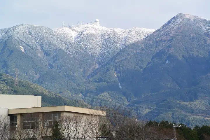
Mount Sangunsan (935.9 m) is the highest peak of the Sangun Range, standing on the meeting point of Iizuka City, Chikushino City and Umi Town in Fukuoka, within Dazaifu Prefectural Natural Park. Its name reflects the historic borders of three old districts (Chikushi, Kasuya and Kaho). An air-traffic monitoring radar of the Ministry of Land, Infrastructure, Transport and Tourism crowns the grassland summit, which commands views of Fukuoka City, the Genkai Sea and the Chikugo Plain. The peak forms the central section of the Mount Homan–Wakasugi traverse.
Mt. Sangunsan at a glance
- Weather: The most settled day in the next 7 days is Sun, November 8: clear, gusts up to 6 m/s.
- Route: The shortest is Mount Homan, Mount Buccho and Mount Sangun Out-and-Back: about 6 h 28 min, 11.1 km, about 1,060 m of climbing.
Mt. Sangunsan weather (hourly, 14 days)
Sunrise today 06:38, sunset 17:25
| Tue, 11/3 | Wed, 11/4 | Thu, 11/5 | Fri, 11/6 | Sat, 11/7 | Sun, 11/8 | Mon, 11/9 | Tue, 11/10 | Wed, 11/11 | Thu, 11/12 | Fri, 11/13 | Sat, 11/14 | Sun, 11/15 | Mon, 11/16 | Tue, 11/17 | |||||||||||||||||||||||||||||||||||||||||||||||||||||||||||||||||||||||
|---|---|---|---|---|---|---|---|---|---|---|---|---|---|---|---|---|---|---|---|---|---|---|---|---|---|---|---|---|---|---|---|---|---|---|---|---|---|---|---|---|---|---|---|---|---|---|---|---|---|---|---|---|---|---|---|---|---|---|---|---|---|---|---|---|---|---|---|---|---|---|---|---|---|---|---|---|---|---|---|---|---|---|---|---|---|
| Japan time | 15 | 17 | 19 | 21 | 23 | 1 | 3 | 5 | 7 | 9 | 11 | 13 | 15 | 18 | 21 | 0 | 3 | 6 | 9 | 12 | 15 | 18 | 21 | 0 | 3 | 6 | 9 | 12 | 15 | 18 | 21 | 0 | 3 | 6 | 9 | 12 | 15 | 18 | 21 | 0 | 3 | 6 | 9 | 12 | 15 | 18 | 21 | 0 | 3 | 6 | 9 | 15 | 21 | 3 | 9 | 15 | 21 | 3 | 9 | 15 | 21 | 3 | 9 | 15 | 21 | 3 | 9 | 15 | 21 | 3 | 9 | 15 | 21 | 3 | 9 | 15 | 21 | 3 | 9 | 15 | 21 | 3 | 9 | 15 | |
  |   |   |   | | | | | |   | | | |   | | | | | |   | |   |   | | | | |  | |  | | | | | | | | | | | | | | | | | | | | | |   | | | | |   | |   | |   |  | | | | | | | | | | | | | | | | | | | | | | | ||
| Temperature | °C | 13° | 11° | 9° | 8° | 7° | 7° | 7° | 6° | 5° | 10° | 13° | 15° | 13° | 10° | 10° | 10° | 10° | 10° | 13° | 13° | 15° | 13° | 13° | 12° | 11° | 9° | 12° | 13° | 11° | 7° | 6° | 5° | 4° | 3° | 6° | 8° | 8° | 4° | 3° | 2° | 1° | 1° | 7° | 9° | 10° | 8° | 6° | 6° | 5° | 6° | 9° | 11° | 5° | 4° | 9° | 9° | 7° | 5° | 7° | 9° | 3° | 0° | 6° | 10° | 4° | 3° | 9° | 12° | 5° | 2° | 7° | 14° | 7° | 8° | 9° | 11° | 11° | 10° | 12° | 13° | 7° | 7° | 8° | 11° |
| Precipitation | mm | 0.9 | 0.4 | 0.1 | 0.1 | 7 | 2.9 | 3.1 | 0.8 | 0.9 | 0.6 | 0.4 | 0.2 | 0.4 | 0.1 | 0.4 | 3.3 | 16 | 16 | 0.6 | 1.2 | 0.1 | |||||||||||||||||||||||||||||||||||||||||||||||||||||||||||||||
| New snow | cm | ||||||||||||||||||||||||||||||||||||||||||||||||||||||||||||||||||||||||||||||||||||
| Snow depth | cm | 0 | 0 | 0 | 0 | 0 | 0 | 0 | 0 | 0 | 0 | 0 | 0 | 0 | 0 | 0 | 0 | 0 | 0 | 0 | 0 | 0 | 0 | 0 | 0 | 0 | 0 | 0 | 0 | 0 | 0 | 0 | 0 | 0 | 0 | 0 | 0 | 0 | 0 | 0 | 0 | 0 | 0 | 0 | 0 | 0 | 0 | 0 | 0 | 0 | 0 | 0 | 0 | 0 | 0 | 0 | 0 | 0 | 0 | 0 | 0 | 0 | 0 | 0 | 0 | 0 | 0 | 0 | 0 | 0 | 0 | 0 | 0 | 0 | 0 | 0 | 0 | 0 | 0 | 0 | 0 | 0 | 0 | 0 | 0 |
| Wind | m/s | 3 | 2 | 1 | 1 | 1 | 1 | 1 | 1 | 1 | 2 | 3 | 3 | 3 | 2 | 1 | 2 | 1 | 1 | 1 | 3 | 4 | 2 | 2 | 2 | 3 | 3 | 5 | 5 | 5 | 3 | 3 | 4 | 3 | 3 | 4 | 4 | 3 | 1 | 0 | 0 | 1 | 1 | 1 | 2 | 2 | 1 | 0 | 0 | 0 | 1 | 0 | 3 | 1 | 0 | 2 | 5 | 1 | 2 | 3 | 3 | 0 | 1 | 1 | 3 | 0 | 1 | 0 | 3 | 1 | 1 | 1 | 2 | 1 | 1 | 1 | 2 | 1 | 2 | 3 | 4 | 3 | 2 | 2 | 3 |
| Wind gusts | m/s | 9 | 9 | 6 | 5 | 4 | 4 | 4 | 4 | 4 | 5 | 9 | 9 | 8 | 9 | 5 | 5 | 5 | 3 | 5 | 10 | 13 | 12 | 7 | 6 | 8 | 8 | 11 | 13 | 14 | 12 | 9 | 11 | 10 | 9 | 10 | 11 | 10 | 8 | 3 | 2 | 2 | 3 | 4 | 5 | 6 | 6 | 2 | 2 | 2 | 4 | 4 | 9 | 9 | 3 | 7 | 12 | 12 | 9 | 7 | 10 | 9 | 2 | 4 | 8 | 7 | 3 | 3 | 8 | 7 | 4 | 4 | 7 | 7 | 5 | 9 | 12 | 10 | 6 | 8 | 11 | 10 | 8 | 6 | 8 |
| Wind dir. | ↓ | ↓ | ↓ | ↓ | ↓ | ↓ | ↓ | ↓ | ↓ | ↓ | ↓ | ↓ | ↓ | ↓ | ↓ | ↓ | ↓ | ↓ | ↓ | ↓ | ↓ | ↓ | ↓ | ↓ | ↓ | ↓ | ↓ | ↓ | ↓ | ↓ | ↓ | ↓ | ↓ | ↓ | ↓ | ↓ | ↓ | ↓ | ↓ | ↓ | ↓ | ↓ | ↓ | ↓ | ↓ | ↓ | ↓ | ↓ | ↓ | ↓ | ↓ | ↓ | ↓ | ↓ | ↓ | ↓ | ↓ | ↓ | ↓ | ↓ | ↓ | ↓ | ↓ | ↓ | ↓ | ↓ | ↓ | ↓ | ↓ | ↓ | ↓ | ↓ | ↓ | ↓ | ↓ | ↓ | ↓ | ↓ | ↓ | ↓ | ↓ | ↓ | ↓ | ↓ | |
Mt. Sangunsan hiking routes
Hiking times are estimates calculated from the terrain.
Huts, campsites and lodging near Mt. Sangunsan
Campsites
- Houmanzan Camp Center
- 宇美町昭和の森キャンプ場
Lists that include Mt. Sangunsan
Mt. Sangunsan facts
- Elevation
- 936 m
- Location
- Iizuka, Fukuoka
33.555540, 130.583775 - Website
- www.pref.fukuoka.lg.jp
- Trail Map
- www.pref.fukuoka.lg.jp (PDF)
- Wikipedia
- ja.wikipedia.org