
Mt. Hane
万年山
Kusu, Oita · Elevation 1,140 m
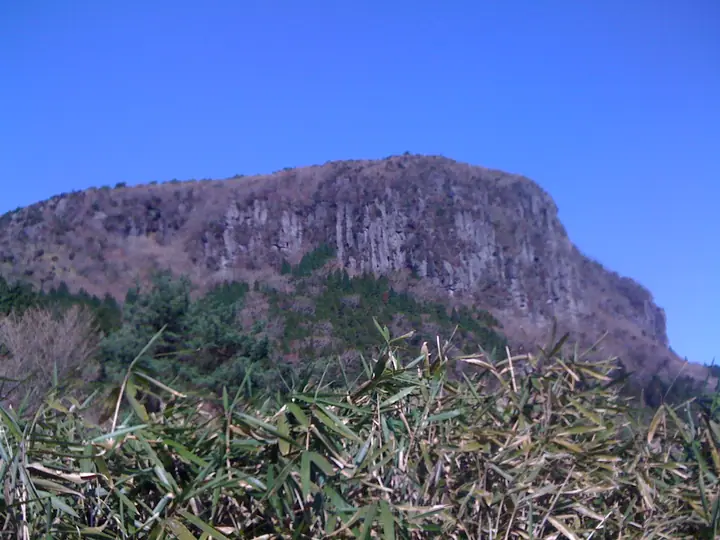
Mt. Hane is a 1,140.3 m peak straddling Kusu Town, Kokonoe Town, and Hita City in Ōita Prefecture, within Yaba-Hita-Hikosan Quasi-National Park. The mountain is celebrated for its nationally rare two-tier mesa structure (lower and upper Hane), selected in 2007 as one of Japan's 100 Geological Sites under the name "Kusu Double Mesa." Its summit plateau bursts with Miyama-kirishima azaleas in May and June, offering panoramic views of the Kujū Range, Mt. Yufu, Mt. Hiko and the Aso volcanic complex. The name "Hane" (literally "leap") comes from a Bungo-no-kuni Fudoki legend that the earth thrown up when the giant Kusu camphor tree was felled formed this mountain. The peak is listed on the Kyushu 100, Ōita 100, Japan 100 Low Mountains, and other major Japanese mountain guides.
Mt. Hane at a glance
- Weather: The most settled day in the next 7 days is Sun, November 8: clear, gusts up to 7 m/s. Thu, Nov 5: strong wind (gusts up to 15 m/s).
- Route: The shortest is Mount Hane and Nishi-Hane Loop from Hanaguri Trailhead: about 4 h 19 min, 9.7 km, about 450 m of climbing.
Mt. Hane weather (hourly, 14 days)
Sunrise today 06:35, sunset 17:23
| Tue, 11/3 | Wed, 11/4 | Thu, 11/5 | Fri, 11/6 | Sat, 11/7 | Sun, 11/8 | Mon, 11/9 | Tue, 11/10 | Wed, 11/11 | Thu, 11/12 | Fri, 11/13 | Sat, 11/14 | Sun, 11/15 | Mon, 11/16 | Tue, 11/17 | |||||||||||||||||||||||||||||||||||||||||||||||||||||||||||||||||||||
|---|---|---|---|---|---|---|---|---|---|---|---|---|---|---|---|---|---|---|---|---|---|---|---|---|---|---|---|---|---|---|---|---|---|---|---|---|---|---|---|---|---|---|---|---|---|---|---|---|---|---|---|---|---|---|---|---|---|---|---|---|---|---|---|---|---|---|---|---|---|---|---|---|---|---|---|---|---|---|---|---|---|---|---|
| Japan time | 21 | 23 | 1 | 3 | 5 | 7 | 9 | 11 | 13 | 15 | 17 | 19 | 21 | 0 | 3 | 6 | 9 | 12 | 15 | 18 | 21 | 0 | 3 | 6 | 9 | 12 | 15 | 18 | 21 | 0 | 3 | 6 | 9 | 12 | 15 | 18 | 21 | 0 | 3 | 6 | 9 | 12 | 15 | 18 | 21 | 0 | 3 | 6 | 9 | 15 | 21 | 3 | 9 | 15 | 21 | 3 | 9 | 15 | 21 | 3 | 9 | 15 | 21 | 3 | 9 | 15 | 21 | 3 | 9 | 15 | 21 | 3 | 9 | 15 | 21 | 3 | 9 | 15 | 21 | 3 | 9 | 15 | |
  | |   | | |   | | | |   | | |   |   | | |   |   | | | |   | |   | | |  |  | | | | | | | | | | | | | |   | | | | | | | | | | | | |   | | | | |  | | | | | | | | | | | | | | | | | |   | | | | | ||
| Temperature | °C | 5° | 4° | 5° | 4° | 6° | 6° | 10° | 12° | 13° | 13° | 11° | 9° | 9° | 9° | 8° | 9° | 12° | 15° | 14° | 13° | 13° | 11° | 10° | 8° | 9° | 12° | 10° | 5° | 3° | 2° | 0° | -1° | 3° | 7° | 7° | 2° | 1° | 0° | -1° | -1° | 6° | 10° | 9° | 6° | 6° | 5° | 5° | 4° | 7° | 9° | 4° | 1° | 5° | 8° | 2° | 2° | 3° | 7° | 1° | -1° | 5° | 8° | 1° | 0° | 7° | 10° | 3° | 2° | 7° | 13° | 5° | 9° | 12° | 12° | 10° | 10° | 9° | 12° | 5° | 5° | 6° | 9° |
| Precipitation | mm | 1.3 | 1.1 | 0.2 | 1.0 | 1.8 | 2.5 | 0.7 | 0.4 | 0.5 | 0.2 | 0.6 | 0.3 | 0.2 | 0.6 | 3.0 | 1.7 | 0.5 | 0.9 | 0.9 | 0.3 | ||||||||||||||||||||||||||||||||||||||||||||||||||||||||||||||
| New snow | cm | – | – | ||||||||||||||||||||||||||||||||||||||||||||||||||||||||||||||||||||||||||||||||
| Snow depth | cm | 0 | 0 | 0 | 0 | 0 | 0 | 0 | 0 | 0 | 0 | 0 | 0 | 0 | 0 | 0 | 0 | 0 | 0 | 0 | 0 | 0 | 0 | 0 | 0 | 0 | 0 | 0 | 0 | 0 | 0 | 0 | 0 | 0 | 0 | 0 | 0 | 0 | 0 | 0 | 0 | 0 | 0 | 0 | 0 | 0 | 0 | 0 | 0 | 0 | 0 | 0 | 0 | 0 | 0 | 0 | 0 | 0 | 0 | 0 | 0 | 0 | 0 | 0 | 0 | 0 | 0 | 0 | 0 | 0 | 0 | 0 | 0 | 0 | 0 | 0 | 0 | 0 | 0 | 0 | 0 | 0 | 0 |
| Wind | m/s | 2 | 1 | 1 | 2 | 2 | 2 | 3 | 3 | 2 | 1 | 2 | 1 | 1 | 2 | 2 | 1 | 1 | 4 | 6 | 3 | 4 | 3 | 4 | 3 | 3 | 5 | 5 | 3 | 2 | 3 | 2 | 2 | 3 | 3 | 3 | 1 | 1 | 1 | 1 | 2 | 1 | 2 | 2 | 1 | 1 | 1 | 0 | 1 | 2 | 3 | 1 | 1 | 1 | 5 | 1 | 3 | 4 | 3 | 1 | 1 | 0 | 2 | 1 | 1 | 2 | 3 | 2 | 2 | 1 | 2 | 2 | 3 | 4 | 1 | 1 | 2 | 3 | 4 | 1 | 2 | 2 | 3 |
| Wind gusts | m/s | 5 | 4 | 4 | 4 | 5 | 5 | 8 | 9 | 8 | 5 | 5 | 5 | 4 | 6 | 5 | 5 | 5 | 10 | 15 | 13 | 9 | 11 | 10 | 10 | 9 | 13 | 13 | 12 | 9 | 8 | 8 | 7 | 9 | 9 | 9 | 8 | 4 | 3 | 3 | 4 | 4 | 6 | 7 | 6 | 3 | 3 | 3 | 3 | 6 | 8 | 8 | 3 | 5 | 12 | 11 | 7 | 10 | 10 | 8 | 3 | 3 | 6 | 6 | 4 | 6 | 10 | 7 | 6 | 5 | 6 | 6 | 8 | 13 | 12 | 8 | 6 | 7 | 10 | 9 | 6 | 6 | 8 |
| Wind dir. | ↓ | ↓ | ↓ | ↓ | ↓ | ↓ | ↓ | ↓ | ↓ | ↓ | ↓ | ↓ | ↓ | ↓ | ↓ | ↓ | ↓ | ↓ | ↓ | ↓ | ↓ | ↓ | ↓ | ↓ | ↓ | ↓ | ↓ | ↓ | ↓ | ↓ | ↓ | ↓ | ↓ | ↓ | ↓ | ↓ | ↓ | ↓ | ↓ | ↓ | ↓ | ↓ | ↓ | ↓ | ↓ | ↓ | ↓ | ↓ | ↓ | ↓ | ↓ | ↓ | ↓ | ↓ | ↓ | ↓ | ↓ | ↓ | ↓ | ↓ | ↓ | ↓ | ↓ | ↓ | ↓ | ↓ | ↓ | ↓ | ↓ | ↓ | ↓ | ↓ | ↓ | ↓ | ↓ | ↓ | ↓ | ↓ | ↓ | ↓ | ↓ | ↓ | |
Mt. Hane hiking routes
Hiking times are estimates calculated from the terrain.
Huts, campsites and lodging near Mt. Hane
Mountain huts
Campsites
- ありが湯キャンプ場
Lists that include Mt. Hane
Kyushu 100 Famous Mountains · Oita 100 Mountains · Elevations of 1003 Mountains of Japan · 1000 Mountains of Japan
Mt. Hane facts
- Also known as
- 羽根山
- Elevation
- 1,140 m
- Location
- Kusu, Oita
33.231324, 131.130533 - National Park
- 耶馬日田英彦山国定公園
- Website
- oita-osoto.jp
- Wikipedia
- ja.wikipedia.org