
Mt. Kirikabu
伐株山
Kusu, Oita · Elevation 685 m
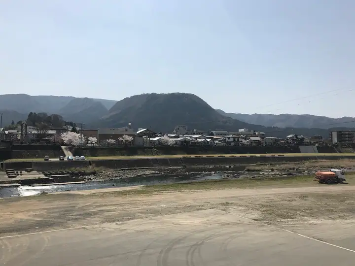
Kirikabusan is a 685 m flat-topped mesa rising from the Kusu Basin in Kusu Town, Oita, formed when a hard cap of volcanic rock resisted erosion while the softer surrounding strata wore away — one of four signature mesas (with Hanesan, Ōganzensan and Aonoyama) that give the basin its skyline. Local legend reads its outline as the stump ("伐株") of a felled giant tree, and it has long been the symbol of the town. A summit shelter called KIRIKABU HOUSE looks out over the basin, the Kyushu Nature Trail crosses the peak north–south, and the broad summit table doubles as a popular paragliding take-off site. The mountain lies inside Yaba-Hita-Hikosan Quasi-National Park.
Mt. Kirikabu at a glance
- Weather: The most settled day in the next 7 days is Sun, November 8: cloudy, gusts up to 7 m/s. Thu, Nov 5: strong wind (gusts up to 15 m/s).
Mt. Kirikabu weather (hourly, 14 days)
Sunrise today 06:36, sunset 17:22
| Tue, 11/3 | Wed, 11/4 | Thu, 11/5 | Fri, 11/6 | Sat, 11/7 | Sun, 11/8 | Mon, 11/9 | Tue, 11/10 | Wed, 11/11 | Thu, 11/12 | Fri, 11/13 | Sat, 11/14 | Sun, 11/15 | Mon, 11/16 | Tue, 11/17 | |||||||||||||||||||||||||||||||||||||||||||||||||||||||||||||||||||||||
|---|---|---|---|---|---|---|---|---|---|---|---|---|---|---|---|---|---|---|---|---|---|---|---|---|---|---|---|---|---|---|---|---|---|---|---|---|---|---|---|---|---|---|---|---|---|---|---|---|---|---|---|---|---|---|---|---|---|---|---|---|---|---|---|---|---|---|---|---|---|---|---|---|---|---|---|---|---|---|---|---|---|---|---|---|---|
| Japan time | 21 | 23 | 1 | 3 | 5 | 7 | 9 | 11 | 13 | 15 | 17 | 19 | 21 | 0 | 3 | 6 | 9 | 12 | 15 | 18 | 21 | 0 | 3 | 6 | 9 | 12 | 15 | 18 | 21 | 0 | 3 | 6 | 9 | 12 | 15 | 18 | 21 | 0 | 3 | 6 | 9 | 12 | 15 | 18 | 21 | 0 | 3 | 6 | 9 | 12 | 15 | 21 | 3 | 9 | 15 | 21 | 3 | 9 | 15 | 21 | 3 | 9 | 15 | 21 | 3 | 9 | 15 | 21 | 3 | 9 | 15 | 21 | 3 | 9 | 15 | 21 | 3 | 9 | 15 | 21 | 3 | 9 | 15 | 21 | |
  | |   | | |   | | | |   | | |   |   | | |   |   | |   | | | | | |   |  |  | | | | | | | | | | | | | |   | | | | | | | | | | | | | |   | | | | |  | | | | | | | | | | | | | | | | | | | |   | | | | ||
| Temperature | °C | 8° | 7° | 8° | 7° | 9° | 9° | 13° | 15° | 16° | 16° | 14° | 12° | 12° | 12° | 11° | 12° | 15° | 18° | 17° | 16° | 14° | 13° | 11° | 9° | 12° | 15° | 13° | 8° | 6° | 5° | 3° | 2° | 7° | 10° | 10° | 5° | 4° | 2° | 1° | 1° | 9° | 14° | 14° | 10° | 9° | 9° | 9° | 9° | 11° | 12° | 11° | 7° | 4° | 8° | 11° | 5° | 5° | 6° | 10° | 4° | 2° | 8° | 11° | 4° | 3° | 10° | 13° | 6° | 5° | 10° | 16° | 8° | 12° | 15° | 15° | 13° | 13° | 12° | 15° | 8° | 8° | 9° | 12° | 6° |
| Precipitation | mm | 1.3 | 1.1 | 0.2 | 1.0 | 1.8 | 1.1 | 0.5 | 0.4 | 0.3 | 0.4 | 0.1 | 0.2 | 0.6 | 3.0 | 1.7 | 0.5 | 0.9 | 0.9 | 0.3 | |||||||||||||||||||||||||||||||||||||||||||||||||||||||||||||||||
| New snow | cm | ||||||||||||||||||||||||||||||||||||||||||||||||||||||||||||||||||||||||||||||||||||
| Snow depth | cm | 0 | 0 | 0 | 0 | 0 | 0 | 0 | 0 | 0 | 0 | 0 | 0 | 0 | 0 | 0 | 0 | 0 | 0 | 0 | 0 | 0 | 0 | 0 | 0 | 0 | 0 | 0 | 0 | 0 | 0 | 0 | 0 | 0 | 0 | 0 | 0 | 0 | 0 | 0 | 0 | 0 | 0 | 0 | 0 | 0 | 0 | 0 | 0 | 0 | 0 | 0 | 0 | 0 | 0 | 0 | 0 | 0 | 0 | 0 | 0 | 0 | 0 | 0 | 0 | 0 | 0 | 0 | 0 | 0 | 0 | 0 | 0 | 0 | 0 | 0 | 0 | 0 | 0 | 0 | 0 | 0 | 0 | 0 | 0 |
| Wind | m/s | 2 | 1 | 1 | 2 | 2 | 2 | 3 | 3 | 2 | 1 | 2 | 1 | 1 | 2 | 2 | 1 | 1 | 4 | 6 | 5 | 5 | 4 | 4 | 2 | 3 | 5 | 5 | 3 | 2 | 2 | 2 | 1 | 4 | 3 | 3 | 2 | 1 | 2 | 2 | 2 | 2 | 1 | 2 | 1 | 1 | 1 | 1 | 0 | 1 | 3 | 2 | 1 | 1 | 1 | 5 | 1 | 3 | 4 | 3 | 1 | 1 | 0 | 2 | 1 | 1 | 2 | 3 | 2 | 2 | 1 | 2 | 2 | 3 | 4 | 1 | 1 | 2 | 3 | 4 | 1 | 2 | 2 | 3 | 1 |
| Wind gusts | m/s | 5 | 4 | 4 | 4 | 5 | 5 | 8 | 9 | 8 | 5 | 5 | 5 | 4 | 6 | 5 | 5 | 5 | 10 | 15 | 14 | 13 | 12 | 11 | 10 | 9 | 13 | 13 | 12 | 8 | 7 | 7 | 7 | 10 | 10 | 9 | 8 | 5 | 4 | 5 | 6 | 6 | 6 | 7 | 7 | 4 | 4 | 3 | 3 | 5 | 7 | 8 | 8 | 3 | 5 | 12 | 11 | 7 | 10 | 10 | 8 | 3 | 3 | 6 | 6 | 4 | 6 | 10 | 7 | 6 | 5 | 6 | 6 | 8 | 13 | 12 | 8 | 6 | 7 | 10 | 9 | 6 | 6 | 8 | 7 |
| Wind dir. | ↓ | ↓ | ↓ | ↓ | ↓ | ↓ | ↓ | ↓ | ↓ | ↓ | ↓ | ↓ | ↓ | ↓ | ↓ | ↓ | ↓ | ↓ | ↓ | ↓ | ↓ | ↓ | ↓ | ↓ | ↓ | ↓ | ↓ | ↓ | ↓ | ↓ | ↓ | ↓ | ↓ | ↓ | ↓ | ↓ | ↓ | ↓ | ↓ | ↓ | ↓ | ↓ | ↓ | ↓ | ↓ | ↓ | ↓ | ↓ | ↓ | ↓ | ↓ | ↓ | ↓ | ↓ | ↓ | ↓ | ↓ | ↓ | ↓ | ↓ | ↓ | ↓ | ↓ | ↓ | ↓ | ↓ | ↓ | ↓ | ↓ | ↓ | ↓ | ↓ | ↓ | ↓ | ↓ | ↓ | ↓ | ↓ | ↓ | ↓ | ↓ | ↓ | ↓ | ↓ | |
Huts, campsites and lodging near Mt. Kirikabu
Mountain huts
Campsites
- ありが湯キャンプ場
Lists that include Mt. Kirikabu
Mt. Kirikabu facts
- Elevation
- 685 m
- Location
- Kusu, Oita
33.261589, 131.139486 - National Park
- 耶馬日田英彦山国定公園
- Website
- kusumachi.jp
- Wikipedia
- ja.wikipedia.org