
Mt. Ganseki
岩石山
Kamishihoro, Hokkaido · Elevation 1,085 m
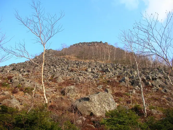
Gansekiyama is a 1,085 m peak in Kamishihoro, Hokkaido. One of the lava domes making up the Shikaribetsu volcanic group south of Lake Shikaribetsu, it has the most extensive scree fields of the group. The mountain lies within Daisetsuzan National Park and is climbed from the Shihoro Highlands Nupuka-no-Sato trailhead or via the adjacent peak of Hakuunzan, whose summit lies only about 450 m away. Its top looks out over the Tokachi Plain.
Mt. Ganseki at a glance
- Weather: The most settled day in the next 7 days is Thu, November 5: cloudy, gusts up to 6 m/s. Wed, Nov 4, Sat, Nov 7, Sun, Nov 8: strong wind (gusts up to 27 m/s).
Mt. Ganseki weather (hourly, 14 days)
Sunrise today 06:04, sunset 16:18
| Tue, 11/3 | Wed, 11/4 | Thu, 11/5 | Fri, 11/6 | Sat, 11/7 | Sun, 11/8 | Mon, 11/9 | Tue, 11/10 | Wed, 11/11 | Thu, 11/12 | Fri, 11/13 | Sat, 11/14 | Sun, 11/15 | Mon, 11/16 | Tue, 11/17 | |||||||||||||||||||||||||||||||||||||||||||||||||||||||||||||||||||||||
|---|---|---|---|---|---|---|---|---|---|---|---|---|---|---|---|---|---|---|---|---|---|---|---|---|---|---|---|---|---|---|---|---|---|---|---|---|---|---|---|---|---|---|---|---|---|---|---|---|---|---|---|---|---|---|---|---|---|---|---|---|---|---|---|---|---|---|---|---|---|---|---|---|---|---|---|---|---|---|---|---|---|---|---|---|---|
| Japan time | 15 | 17 | 19 | 21 | 23 | 1 | 3 | 5 | 7 | 9 | 11 | 13 | 15 | 18 | 21 | 0 | 3 | 6 | 9 | 12 | 15 | 18 | 21 | 0 | 3 | 6 | 9 | 12 | 15 | 18 | 21 | 0 | 3 | 6 | 9 | 12 | 15 | 18 | 21 | 0 | 3 | 6 | 9 | 12 | 15 | 18 | 21 | 0 | 3 | 6 | 9 | 15 | 21 | 3 | 9 | 15 | 21 | 3 | 9 | 15 | 21 | 3 | 9 | 15 | 21 | 3 | 9 | 15 | 21 | 3 | 9 | 15 | 21 | 3 | 9 | 15 | 21 | 3 | 9 | 15 | 21 | 3 | 9 | 15 | |
  |   |  |   | |   |   | | | | | |  |  | | | | |   |   | | |   | | | |   | |   |   | | |   | |   | |   | | | | | | | | | | | | | | | |   | | | | |   | |   | | | | | | | | | |  | | | | | | | | | |   |   | | | | ||
| Temperature | °C | -1° | -3° | -4° | -4° | -4° | -5° | -4° | -3° | -2° | -1° | 0° | 0° | 0° | -4° | -4° | -3° | -3° | -2° | 4° | 5° | 4° | 1° | 1° | 2° | 4° | 4° | 4° | 5° | 6° | 4° | 0° | -3° | -6° | -7° | -5° | -4° | -6° | -6° | -6° | -6° | -7° | -7° | -5° | -4° | -4° | -5° | -6° | -6° | -6° | -7° | -5° | -5° | -9° | -9° | -5° | -4° | -7° | -6° | -4° | -3° | -5° | -9° | -3° | -3° | -7° | -8° | -7° | -6° | -8° | -13° | -4° | -2° | -6° | -7° | 2° | 2° | 0° | 0° | 2° | -2° | -5° | -6° | -4° | -3° |
| Precipitation | mm | 1.4 | 0.1 | 0.4 | 2.1 | 3.0 | 2.8 | 5 | 1.5 | 0.4 | 0.2 | 0.2 | 0.2 | 0.3 | 0.3 | 0.3 | 0.3 | 0.5 | 0.5 | 0.5 | 0.5 | 0.4 | 0.3 | 0.2 | 0.8 | 1.9 | 0.3 | 0.6 | 0.4 | 0.4 | 3.2 | 1.3 | |||||||||||||||||||||||||||||||||||||||||||||||||||||
| New snow | cm | 1.4 | 0.1 | 0.1 | 0.3 | <.1 | 0.3 | 0.3 | 0.3 | 0.5 | 0.4 | 0.5 | 0.5 | 0.4 | 0.3 | 0.2 | 0.8 | 1.9 | 0.1 | <.1 | <.1 | <.1 | 0.3 | 0.7 | 0.9 | <.1 | |||||||||||||||||||||||||||||||||||||||||||||||||||||||||||
| Snow depth | cm | 0 | 0 | 0 | 0 | 0 | 0 | <1 | <1 | <1 | <1 | <1 | <1 | <1 | <1 | <1 | <1 | <1 | <1 | <1 | <1 | 0 | 0 | 0 | 0 | 0 | 0 | 0 | 0 | 0 | 0 | 0 | 0 | 0 | 0 | 0 | <1 | <1 | <1 | <1 | <1 | 2 | 2 | 2 | 2 | 2 | 2 | 2 | 2 | 2 | 2 | 2 | 2 | 2 | 2 | 2 | 2 | 2 | 2 | 4 | 3 | 3 | 3 | 3 | 3 | 3 | 3 | 3 | 2 | 3 | 2 | 2 | 2 | 2 | 2 | 2 | <1 | <1 | <1 | <1 | <1 | 1 | 1 | 1 | 1 |
| Wind | m/s | 6 | 5 | 4 | 4 | 4 | 4 | 2 | 4 | 7 | 7 | 8 | 6 | 4 | 3 | 3 | 3 | 3 | 2 | 1 | 1 | 1 | 2 | 1 | 1 | 1 | 1 | 1 | 1 | 2 | 7 | 6 | 6 | 7 | 7 | 8 | 10 | 10 | 9 | 9 | 8 | 10 | 11 | 11 | 10 | 9 | 9 | 10 | 7 | 4 | 4 | 4 | 5 | 3 | 3 | 2 | 1 | 1 | 2 | 1 | 0 | 1 | 2 | 3 | 4 | 3 | 2 | 5 | 4 | 0 | 2 | 0 | 1 | 1 | 2 | 2 | 4 | 2 | 2 | 1 | 2 | 4 | 4 | 1 | 2 |
| Wind gusts | m/s | 17 | 15 | 12 | 12 | 11 | 10 | 10 | 10 | 16 | 18 | 19 | 19 | 15 | 9 | 8 | 10 | 9 | 8 | 6 | 5 | 5 | 3 | 3 | 2 | 3 | 3 | 4 | 5 | 7 | 17 | 18 | 17 | 18 | 19 | 19 | 23 | 26 | 26 | 25 | 23 | 24 | 26 | 26 | 27 | 23 | 23 | 23 | 23 | 17 | 10 | 10 | 14 | 12 | 8 | 8 | 6 | 4 | 5 | 6 | 5 | 3 | 5 | 7 | 13 | 11 | 9 | 12 | 13 | 14 | 6 | 5 | 5 | 4 | 7 | 9 | 11 | 11 | 6 | 7 | 5 | 9 | 11 | 10 | 6 |
| Wind dir. | ↓ | ↓ | ↓ | ↓ | ↓ | ↓ | ↓ | ↓ | ↓ | ↓ | ↓ | ↓ | ↓ | ↓ | ↓ | ↓ | ↓ | ↓ | ↓ | ↓ | ↓ | ↓ | ↓ | ↓ | ↓ | ↓ | ↓ | ↓ | ↓ | ↓ | ↓ | ↓ | ↓ | ↓ | ↓ | ↓ | ↓ | ↓ | ↓ | ↓ | ↓ | ↓ | ↓ | ↓ | ↓ | ↓ | ↓ | ↓ | ↓ | ↓ | ↓ | ↓ | ↓ | ↓ | ↓ | ↓ | ↓ | ↓ | ↓ | ↓ | ↓ | ↓ | ↓ | ↓ | ↓ | ↓ | ↓ | ↓ | ↓ | ↓ | ↓ | ↓ | ↓ | ↓ | ↓ | ↓ | ↓ | ↓ | ↓ | ↓ | ↓ | ↓ | ↓ | ↓ | |
Huts, campsites and lodging near Mt. Ganseki
Campsites
- 国設然別湖北岸野営場
Lodging
- 士幌小屋チセ・フレップ
- 然別湖畔溫泉旅館(風水)
Mt. Ganseki facts
- Elevation
- 1,085 m
- Location
- Kamishihoro, Hokkaido
43.255201, 143.117566 - National Park
- 大雪山国立公園
- Website
- hokkaido.env.go.jp
- Wikipedia
- ja.wikipedia.org