
Mt. Awagatake
粟ヶ岳
Sanjō-shi, Niigata / Kamo, Niigata · Elevation 1,293 m
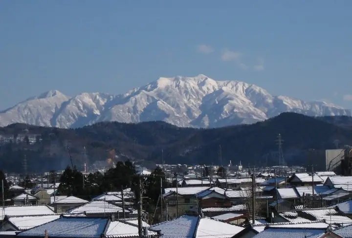
Awagatake (1,293 m) rises at the boundary between Kamo and Sanjō cities in central Niigata Prefecture and is the principal peak of the Kawauchi range, listed among the 300 Famous Mountains of Japan. Two main trails ascend the peak — the Central Route from the Kamo prefectural recreation area via the Awagatake Hut, and the Shimoda route from the Kita-Iogawa trailhead in Sanjō via Awa-Yakushi — both offering broad views to Yahiko-yama, Sado Island and the Noto Peninsula on clear days. A spring mountain-opening hike is held on the Kamo side, and the slopes are noted for their colonies of Himesayuri lilies.
Mt. Awagatake at a glance
- Weather: The most settled day in the next 7 days is Wed, November 4: clear, gusts up to 8 m/s. Fri, Nov 6, Sat, Nov 7: strong wind (gusts up to 20 m/s).
- Route: The shortest is Mount Awagatake via the Kitagokawa Trail: about 7 h, 10.5 km, about 1,180 m of climbing.
Mt. Awagatake weather (hourly, 14 days)
Sunrise today 06:09, sunset 16:44
| Tue, 11/3 | Wed, 11/4 | Thu, 11/5 | Fri, 11/6 | Sat, 11/7 | Sun, 11/8 | Mon, 11/9 | Tue, 11/10 | Wed, 11/11 | Thu, 11/12 | Fri, 11/13 | Sat, 11/14 | Sun, 11/15 | Mon, 11/16 | Tue, 11/17 | |||||||||||||||||||||||||||||||||||||||||||||||||||||||||||||||||||||||
|---|---|---|---|---|---|---|---|---|---|---|---|---|---|---|---|---|---|---|---|---|---|---|---|---|---|---|---|---|---|---|---|---|---|---|---|---|---|---|---|---|---|---|---|---|---|---|---|---|---|---|---|---|---|---|---|---|---|---|---|---|---|---|---|---|---|---|---|---|---|---|---|---|---|---|---|---|---|---|---|---|---|---|---|---|---|
| Japan time | 15 | 17 | 19 | 21 | 23 | 1 | 3 | 5 | 7 | 9 | 11 | 13 | 15 | 18 | 21 | 0 | 3 | 6 | 9 | 12 | 15 | 18 | 21 | 0 | 3 | 6 | 9 | 12 | 15 | 18 | 21 | 0 | 3 | 6 | 9 | 12 | 15 | 18 | 21 | 0 | 3 | 6 | 9 | 12 | 15 | 18 | 21 | 0 | 3 | 6 | 9 | 15 | 21 | 3 | 9 | 15 | 21 | 3 | 9 | 15 | 21 | 3 | 9 | 15 | 21 | 3 | 9 | 15 | 21 | 3 | 9 | 15 | 21 | 3 | 9 | 15 | 21 | 3 | 9 | 15 | 21 | 3 | 9 | 15 | |
 |  | | | | | |   | | | | |   | |   |   |   | |   |   |   | |   |   | | | | | | | | | | | |   |   | | | | | | | | | | | | | | |   | |   | | | |   | | | | | | | | | | | | | | |  | | | | | | | | | | | | ||
| Temperature | °C | 6° | 2° | 1° | 0° | -2° | -2° | -1° | 0° | 2° | 6° | 8° | 9° | 9° | 5° | 4° | 5° | 4° | 4° | 6° | 8° | 11° | 7° | 8° | 8° | 6° | 7° | 7° | 9° | 7° | 4° | 3° | 1° | 1° | -1° | 0° | 1° | 0° | -2° | -1° | -2° | -1° | -1° | 1° | 2° | 2° | 0° | 0° | 0° | 0° | -1° | 1° | 1° | -1° | -4° | 3° | 9° | 2° | -2° | 1° | 0° | -1° | -1° | 1° | 3° | -1° | 0° | 1° | 1° | -1° | -1° | 2° | 4° | -2° | -2° | 8° | 9° | 3° | 4° | 5° | 2° | -2° | -3° | 0° | 1° |
| Precipitation | mm | 5.0 | 12 | 3.6 | 2.0 | 0.2 | 0.6 | 2.2 | 2.7 | 4.9 | 1.6 | 5 | 4.8 | 6 | 8 | 5 | 3.9 | 3.1 | 3.5 | 1.7 | 0.6 | 1.7 | 1.3 | 1.1 | 0.1 | 0.2 | 0.5 | 0.3 | 0.1 | 0.3 | 0.6 | 0.7 | 0.2 | 2.8 | 10 | 6 | 6 | 2.4 | 0.6 | 0.5 | 1.3 | 3.0 | 8 | 3.7 | 4.1 | 4.2 | 12 | 4.9 | 0.2 | ||||||||||||||||||||||||||||||||||||
| New snow | cm | 0.1 | <.1 | 0.1 | 0.6 | <.1 | |||||||||||||||||||||||||||||||||||||||||||||||||||||||||||||||||||||||||||||||
| Snow depth | cm | 0 | 0 | 0 | 0 | 0 | 0 | 0 | 0 | 0 | 0 | 0 | 0 | 0 | 0 | 0 | 0 | 0 | 0 | 0 | 0 | 0 | 0 | 0 | 0 | 0 | 0 | 0 | 0 | 0 | 0 | 0 | 0 | 0 | 0 | 0 | 0 | 0 | 0 | 0 | 0 | 0 | 0 | 0 | 0 | 0 | 0 | 0 | 0 | 0 | 0 | 0 | 0 | 0 | 0 | 0 | 0 | 0 | <1 | <1 | <1 | 0 | 0 | 0 | 0 | 0 | 0 | 0 | 0 | 0 | 0 | 0 | 0 | 0 | 0 | 0 | 0 | 0 | 0 | 0 | 0 | 0 | 0 | 0 | 0 |
| Wind | m/s | 3 | 1 | 0 | 1 | 2 | 2 | 1 | 1 | 1 | 1 | 2 | 3 | 3 | 4 | 4 | 5 | 4 | 3 | 3 | 2 | 1 | 1 | 1 | 1 | 1 | 3 | 5 | 5 | 6 | 4 | 4 | 3 | 4 | 4 | 6 | 7 | 7 | 5 | 5 | 5 | 5 | 3 | 5 | 5 | 3 | 1 | 1 | 1 | 1 | 1 | 2 | 3 | 1 | 2 | 2 | 2 | 4 | 2 | 3 | 4 | 1 | 1 | 2 | 3 | 2 | 4 | 4 | 4 | 1 | 1 | 1 | 2 | 1 | 1 | 2 | 0 | 4 | 4 | 1 | 6 | 4 | 0 | 1 | 2 |
| Wind gusts | m/s | 11 | 8 | 3 | 3 | 4 | 4 | 4 | 3 | 2 | 4 | 6 | 7 | 8 | 9 | 9 | 12 | 12 | 9 | 10 | 8 | 6 | 4 | 4 | 5 | 4 | 9 | 13 | 15 | 17 | 15 | 14 | 11 | 12 | 13 | 16 | 19 | 20 | 18 | 13 | 13 | 13 | 11 | 12 | 13 | 13 | 8 | 3 | 3 | 2 | 3 | 5 | 8 | 8 | 4 | 6 | 9 | 12 | 16 | 18 | 19 | 12 | 5 | 6 | 11 | 8 | 12 | 11 | 12 | 11 | 4 | 4 | 6 | 5 | 3 | 5 | 5 | 9 | 10 | 7 | 14 | 14 | 10 | 4 | 6 |
| Wind dir. | ↓ | ↓ | ↓ | ↓ | ↓ | ↓ | ↓ | ↓ | ↓ | ↓ | ↓ | ↓ | ↓ | ↓ | ↓ | ↓ | ↓ | ↓ | ↓ | ↓ | ↓ | ↓ | ↓ | ↓ | ↓ | ↓ | ↓ | ↓ | ↓ | ↓ | ↓ | ↓ | ↓ | ↓ | ↓ | ↓ | ↓ | ↓ | ↓ | ↓ | ↓ | ↓ | ↓ | ↓ | ↓ | ↓ | ↓ | ↓ | ↓ | ↓ | ↓ | ↓ | ↓ | ↓ | ↓ | ↓ | ↓ | ↓ | ↓ | ↓ | ↓ | ↓ | ↓ | ↓ | ↓ | ↓ | ↓ | ↓ | ↓ | ↓ | ↓ | ↓ | ↓ | ↓ | ↓ | ↓ | ↓ | ↓ | ↓ | ↓ | ↓ | ↓ | ↓ | ↓ | |
Mt. Awagatake hiking routes
- Mount Awagatake via the Kitagokawa Trail 10.5 km · Ascent 1,180 m 粟ヶ岳登山口, 粟ヶ岳 北五百川コース登山口駐車場
- Mount Awagatake Central Trail Out-and-Back 11.6 km · Ascent 1,296 m parking
Hiking times are estimates calculated from the terrain.
Huts, campsites and lodging near Mt. Awagatake
Mountain huts
Campsites
- Awagatake Kenmin Kyuyochi Camping Ground
Lists that include Mt. Awagatake
Japan's 300 Famous Mountains · 100 Famous Hot Spring Mountains · Niigata 100 Famous Mountains · Elevations of 1003 Mountains of Japan · 1000 Mountains of Japan
Mt. Awagatake facts
- Elevation
- 1,293 m
- Location
- Sanjō-shi, Niigata / Kamo, Niigata
37.555227, 139.188736 - Season Opens
- April 29
- Season Closes
- November 3
- Website
- www.city.sanjo.niigata.jp
- Trail Map
- www.city.kamo.niigata.jp (PDF)
- Access Information
- niigata-kankou.or.jp
- Wikipedia
- ja.wikipedia.org