
Mt. Ariakeyama
有明山
Chikuma, Nagano · Elevation 652 m
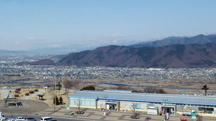
Mt. Ariake-yama (652 m) is a sato-yama at the northern edge of Chikuma City, Nagano Prefecture, on the ridge extending south from Mt. Gorigamine south-east of Yashiro Station on the Shinano Railway. The Mori-Shōgunzuka Kofun — a 100-m keyhole-shaped tumulus designated a national historic site — sits on its upper slopes, and a circuit hike leaves the Shinano-no-Sato Historical Park, climbs past the tomb to the wooded summit, and returns to the park. Although the summit itself is hemmed in by trees, the descent affords views over the Chikuma River and the Northern Alps.
Mt. Ariakeyama at a glance
- Weather: The most settled day in the next 7 days is Wed, November 4: clear, gusts up to 5 m/s.
Mt. Ariakeyama weather (hourly, 14 days)
Sunrise today 06:12, sunset 16:50
| Tue, 11/3 | Wed, 11/4 | Thu, 11/5 | Fri, 11/6 | Sat, 11/7 | Sun, 11/8 | Mon, 11/9 | Tue, 11/10 | Wed, 11/11 | Thu, 11/12 | Fri, 11/13 | Sat, 11/14 | Sun, 11/15 | Mon, 11/16 | Tue, 11/17 | |||||||||||||||||||||||||||||||||||||||||||||||||||||||||||||||||||||||
|---|---|---|---|---|---|---|---|---|---|---|---|---|---|---|---|---|---|---|---|---|---|---|---|---|---|---|---|---|---|---|---|---|---|---|---|---|---|---|---|---|---|---|---|---|---|---|---|---|---|---|---|---|---|---|---|---|---|---|---|---|---|---|---|---|---|---|---|---|---|---|---|---|---|---|---|---|---|---|---|---|---|---|---|---|---|
| Japan time | 21 | 23 | 1 | 3 | 5 | 7 | 9 | 11 | 13 | 15 | 17 | 19 | 21 | 0 | 3 | 6 | 9 | 12 | 15 | 18 | 21 | 0 | 3 | 6 | 9 | 12 | 15 | 18 | 21 | 0 | 3 | 6 | 9 | 12 | 15 | 18 | 21 | 0 | 3 | 6 | 9 | 12 | 15 | 18 | 21 | 0 | 3 | 6 | 9 | 12 | 15 | 21 | 3 | 9 | 15 | 21 | 3 | 9 | 15 | 21 | 3 | 9 | 15 | 21 | 3 | 9 | 15 | 21 | 3 | 9 | 15 | 21 | 3 | 9 | 15 | 21 | 3 | 9 | 15 | 21 | 3 | 9 | 15 | 21 | |
  |   | | | |   |   | |  | | | | |   | |   |   | |   | | | | | | | | | | | | | |   | | | | | | | | | | | | |   | | | | | | | | | | | |   |   | | | | |  | |   | | | | | | | | | | | | | | | | | |  | ||
| Temperature | °C | 3° | 1° | 1° | 1° | 1° | 1° | 6° | 11° | 14° | 14° | 10° | 9° | 9° | 8° | 8° | 8° | 9° | 13° | 14° | 11° | 10° | 8° | 8° | 7° | 12° | 16° | 16° | 11° | 8° | 5° | 3° | 1° | 3° | 6° | 7° | 1° | -1° | -2° | -1° | -1° | 4° | 8° | 6° | 2° | 1° | 1° | 0° | 1° | 4° | 12° | 9° | 4° | 2° | 5° | 12° | 5° | 3° | 1° | 5° | 2° | 0° | 4° | 8° | 1° | 0° | 4° | 6° | 1° | -1° | 3° | 11° | 3° | 0° | 5° | 14° | 8° | 6° | 9° | 10° | 4° | 2° | 4° | 8° | 1° |
| Precipitation | mm | 2.9 | 9 | 2.1 | 0.8 | 0.1 | 0.1 | 0.6 | 3.5 | 1.1 | 0.2 | 0.1 | 0.1 | 0.5 | 1.1 | 0.1 | 1.5 | 2.4 | 1.3 | 0.5 | 0.3 | 3.9 | 5 | 0.3 | 1.1 | 0.3 | 0.1 | ||||||||||||||||||||||||||||||||||||||||||||||||||||||||||
| New snow | cm | – | – | – | 1.1 | <.1 | |||||||||||||||||||||||||||||||||||||||||||||||||||||||||||||||||||||||||||||||
| Snow depth | cm | 0 | 0 | 0 | 0 | 0 | 0 | 0 | 0 | 0 | 0 | 0 | 0 | 0 | 0 | 0 | 0 | 0 | 0 | 0 | 0 | 0 | 0 | 0 | 0 | 0 | 0 | 0 | 0 | 0 | 0 | 0 | 0 | 0 | 0 | 0 | 0 | 0 | 0 | 0 | 0 | 0 | 0 | 0 | 0 | 0 | 0 | 0 | 0 | 0 | 0 | 0 | 0 | 0 | 0 | 0 | 0 | 0 | <1 | 0 | 0 | 0 | 0 | 0 | 0 | 0 | 0 | 0 | 0 | 0 | 0 | 0 | 0 | 0 | 0 | 0 | 0 | 0 | 0 | 0 | 0 | 0 | 0 | 0 | 0 |
| Wind | m/s | 0 | 0 | 0 | 0 | 1 | 1 | 1 | 1 | 1 | 1 | 1 | 2 | 2 | 1 | 1 | 1 | 1 | 1 | 1 | 1 | 0 | 0 | 0 | 1 | 1 | 1 | 3 | 2 | 1 | 2 | 1 | 1 | 2 | 1 | 2 | 1 | 1 | 1 | 0 | 1 | 1 | 4 | 4 | 1 | 1 | 1 | 0 | 1 | 1 | 2 | 4 | 1 | 0 | 1 | 4 | 0 | 4 | 1 | 3 | 1 | 1 | 1 | 4 | 1 | 0 | 1 | 4 | 0 | 1 | 1 | 2 | 1 | 1 | 1 | 1 | 1 | 0 | 1 | 4 | 3 | 1 | 1 | 3 | 0 |
| Wind gusts | m/s | 3 | 2 | 2 | 2 | 2 | 3 | 4 | 5 | 5 | 5 | 4 | 6 | 7 | 6 | 5 | 5 | 5 | 5 | 4 | 3 | 5 | 4 | 4 | 3 | 4 | 5 | 10 | 10 | 8 | 6 | 6 | 4 | 5 | 6 | 7 | 7 | 5 | 4 | 4 | 4 | 5 | 11 | 12 | 11 | 4 | 4 | 3 | 3 | 4 | 7 | 12 | 10 | 5 | 4 | 10 | 11 | 13 | 12 | 11 | 10 | 4 | 4 | 12 | 12 | 3 | 5 | 12 | 12 | 3 | 4 | 5 | 5 | 4 | 4 | 5 | 4 | 6 | 5 | 14 | 13 | 9 | 5 | 8 | 7 |
| Wind dir. | ↓ | ↓ | ↓ | ↓ | ↓ | ↓ | ↓ | ↓ | ↓ | ↓ | ↓ | ↓ | ↓ | ↓ | ↓ | ↓ | ↓ | ↓ | ↓ | ↓ | ↓ | ↓ | ↓ | ↓ | ↓ | ↓ | ↓ | ↓ | ↓ | ↓ | ↓ | ↓ | ↓ | ↓ | ↓ | ↓ | ↓ | ↓ | ↓ | ↓ | ↓ | ↓ | ↓ | ↓ | ↓ | ↓ | ↓ | ↓ | ↓ | ↓ | ↓ | ↓ | ↓ | ↓ | ↓ | ↓ | ↓ | ↓ | ↓ | ↓ | ↓ | ↓ | ↓ | ↓ | ↓ | ↓ | ↓ | ↓ | ↓ | ↓ | ↓ | ↓ | ↓ | ↓ | ↓ | ↓ | ↓ | ↓ | ↓ | ↓ | ↓ | ↓ | ↓ | ↓ | |
Huts, campsites and lodging near Mt. Ariakeyama
Mountain huts
- 姪石苑
Lodging
- フィオナリラクレア
- うづらや
- 日本棚田No.1
- ゲストハウスなからや
- 笹屋ホテル
Mt. Ariakeyama facts
- Elevation
- 652 m
- Location
- Chikuma, Nagano
36.526170, 138.138077 - Website
- www.city.chikuma.lg.jp (PDF)
- Access Information
- www.city.chikuma.lg.jp
- Wikipedia
- ja.wikipedia.org