
Mt. Akasakayama
赤坂山
Mihama, Fukui · Elevation 824 m
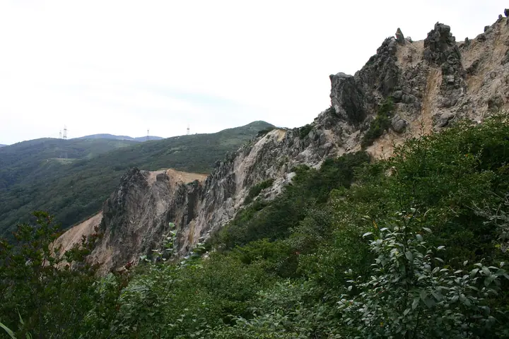
Mt. Akasakayama is an 823.8 m peak on the main ridge of the Nosaka Mountains, straddling the boundary between Makino-cho in Takashima City, Shiga Prefecture and Mihama-cho in Fukui Prefecture. The summit lies on the Central Watershed of Japan and offers near-360° views taking in Lake Biwa, Mt. Ibuki and even Mt. Hakusan; it is renowned as a flower mountain, with the white granite scree of Myōō-no-Hage and spring colonies of katakuri and iwauchiwa. It is a waypoint on the Takashima Trail and appears on lists including the Kansai Hyakumeizan, Yamakei Flower Hyakumeizan, and the Shiga and Fukui Bunken Tozan Guides.
Mt. Akasakayama at a glance
- Weather: The most settled day in the next 7 days is Wed, November 4: clear, gusts up to 7 m/s. Fri, Nov 6, Sat, Nov 7: strong wind (gusts up to 18 m/s).
- Route: The shortest is Akasakayama and Kampu Loop from Makino Kogen: about 6 h 22 min, 10.9 km, about 850 m of climbing.
Mt. Akasakayama weather (hourly, 14 days)
Sunrise today 06:19, sunset 17:00
| Tue, 11/3 | Wed, 11/4 | Thu, 11/5 | Fri, 11/6 | Sat, 11/7 | Sun, 11/8 | Mon, 11/9 | Tue, 11/10 | Wed, 11/11 | Thu, 11/12 | Fri, 11/13 | Sat, 11/14 | Sun, 11/15 | Mon, 11/16 | Tue, 11/17 | |||||||||||||||||||||||||||||||||||||||||||||||||||||||||||||||||||||||
|---|---|---|---|---|---|---|---|---|---|---|---|---|---|---|---|---|---|---|---|---|---|---|---|---|---|---|---|---|---|---|---|---|---|---|---|---|---|---|---|---|---|---|---|---|---|---|---|---|---|---|---|---|---|---|---|---|---|---|---|---|---|---|---|---|---|---|---|---|---|---|---|---|---|---|---|---|---|---|---|---|---|---|---|---|---|
| Japan time | 15 | 17 | 19 | 21 | 23 | 1 | 3 | 5 | 7 | 9 | 11 | 13 | 15 | 18 | 21 | 0 | 3 | 6 | 9 | 12 | 15 | 18 | 21 | 0 | 3 | 6 | 9 | 12 | 15 | 18 | 21 | 0 | 3 | 6 | 9 | 12 | 15 | 18 | 21 | 0 | 3 | 6 | 9 | 12 | 15 | 18 | 21 | 0 | 3 | 6 | 9 | 15 | 21 | 3 | 9 | 15 | 21 | 3 | 9 | 15 | 21 | 3 | 9 | 15 | 21 | 3 | 9 | 15 | 21 | 3 | 9 | 15 | 21 | 3 | 9 | 15 | 21 | 3 | 9 | 15 | 21 | 3 | 9 | 15 | |
 |   | | | | | | |   | | | |   |   | |   |   | |   | | | | | | | |   |   | | | | | | | | | | | | | | | | | |   | | | | | | |   | | | | | | | | | | |   | | | | |  | | | | | | | | | | | | | | | | ||
| Temperature | °C | 14° | 11° | 9° | 9° | 8° | 7° | 7° | 7° | 7° | 12° | 15° | 16° | 16° | 12° | 11° | 11° | 10° | 10° | 12° | 16° | 16° | 13° | 13° | 13° | 12° | 12° | 13° | 17° | 12° | 11° | 9° | 8° | 8° | 6° | 6° | 8° | 8° | 6° | 7° | 7° | 7° | 6° | 8° | 10° | 10° | 8° | 7° | 7° | 6° | 6° | 10° | 10° | 6° | 4° | 9° | 10° | 7° | 6° | 8° | 9° | 7° | 4° | 9° | 10° | 6° | 7° | 8° | 9° | 6° | 3° | 9° | 13° | 6° | 8° | 10° | 13° | 11° | 10° | 12° | 11° | 7° | 5° | 6° | 10° |
| Precipitation | mm | 1.2 | 3.8 | 3.5 | 2.6 | 1.6 | 0.6 | 12 | 2.1 | 2.5 | 0.4 | 1.5 | 0.8 | 0.8 | 0.5 | 0.4 | 1.0 | 1.6 | 1.5 | 1.1 | 0.2 | 0.1 | 1.1 | 0.6 | 1.7 | 4.7 | 3.4 | 0.2 | 0.3 | 2.0 | 3.5 | 7 | 10 | 3.3 | 2.9 | 0.5 | |||||||||||||||||||||||||||||||||||||||||||||||||
| New snow | cm | ||||||||||||||||||||||||||||||||||||||||||||||||||||||||||||||||||||||||||||||||||||
| Snow depth | cm | 0 | 0 | 0 | 0 | 0 | 0 | 0 | 0 | 0 | 0 | 0 | 0 | 0 | 0 | 0 | 0 | 0 | 0 | 0 | 0 | 0 | 0 | 0 | 0 | 0 | 0 | 0 | 0 | 0 | 0 | 0 | 0 | 0 | 0 | 0 | 0 | 0 | 0 | 0 | 0 | 0 | 0 | 0 | 0 | 0 | 0 | 0 | 0 | 0 | 0 | 0 | 0 | 0 | 0 | 0 | 0 | 0 | 0 | 0 | 0 | 0 | 0 | 0 | 0 | 0 | 0 | 0 | 0 | 0 | 0 | 0 | 0 | 0 | 0 | 0 | 0 | 0 | 0 | 0 | 0 | 0 | 0 | 0 | 0 |
| Wind | m/s | 4 | 3 | 3 | 3 | 2 | 2 | 3 | 2 | 2 | 2 | 2 | 1 | 1 | 1 | 1 | 1 | 2 | 0 | 0 | 0 | 0 | 1 | 1 | 2 | 2 | 3 | 3 | 6 | 4 | 5 | 5 | 6 | 6 | 6 | 6 | 6 | 6 | 4 | 4 | 3 | 3 | 2 | 4 | 5 | 4 | 2 | 2 | 1 | 1 | 0 | 2 | 3 | 0 | 1 | 3 | 3 | 3 | 8 | 8 | 7 | 4 | 2 | 2 | 3 | 0 | 1 | 5 | 6 | 3 | 2 | 1 | 3 | 2 | 3 | 3 | 4 | 4 | 1 | 4 | 7 | 6 | 4 | 4 | 3 |
| Wind gusts | m/s | 11 | 11 | 8 | 9 | 9 | 7 | 7 | 8 | 7 | 6 | 6 | 5 | 4 | 3 | 4 | 4 | 8 | 7 | 3 | 4 | 4 | 2 | 4 | 5 | 6 | 8 | 10 | 15 | 16 | 13 | 13 | 15 | 16 | 16 | 16 | 18 | 17 | 16 | 12 | 11 | 10 | 8 | 10 | 13 | 13 | 10 | 7 | 5 | 4 | 4 | 5 | 11 | 8 | 3 | 8 | 11 | 10 | 20 | 22 | 20 | 18 | 11 | 7 | 9 | 8 | 7 | 14 | 17 | 16 | 10 | 7 | 9 | 8 | 7 | 9 | 12 | 11 | 12 | 11 | 18 | 18 | 15 | 12 | 11 |
| Wind dir. | ↓ | ↓ | ↓ | ↓ | ↓ | ↓ | ↓ | ↓ | ↓ | ↓ | ↓ | ↓ | ↓ | ↓ | ↓ | ↓ | ↓ | ↓ | ↓ | ↓ | ↓ | ↓ | ↓ | ↓ | ↓ | ↓ | ↓ | ↓ | ↓ | ↓ | ↓ | ↓ | ↓ | ↓ | ↓ | ↓ | ↓ | ↓ | ↓ | ↓ | ↓ | ↓ | ↓ | ↓ | ↓ | ↓ | ↓ | ↓ | ↓ | ↓ | ↓ | ↓ | ↓ | ↓ | ↓ | ↓ | ↓ | ↓ | ↓ | ↓ | ↓ | ↓ | ↓ | ↓ | ↓ | ↓ | ↓ | ↓ | ↓ | ↓ | ↓ | ↓ | ↓ | ↓ | ↓ | ↓ | ↓ | ↓ | ↓ | ↓ | ↓ | ↓ | ↓ | ||
Mt. Akasakayama hiking routes
Hiking times are estimates calculated from the terrain.
Huts, campsites and lodging near Mt. Akasakayama
Campsites
- マキノ高原
Lists that include Mt. Akasakayama
Kansai 100 Famous Mountains · 100 Mountains of Hokuriku · Omi 100 Mountains · Takashima Trail
Mt. Akasakayama facts
- Elevation
- 824 m
- Location
- Mihama, Fukui
35.520102, 136.023450 - Website
- www.city.takashima.lg.jp
- Trail Map
- www.pref.shiga.lg.jp (PDF)
- Access Information
- takashima-kanko.jp
- Wikipedia
- ja.wikipedia.org