
Mount Norikura
乗鞍岳
Takashima, Shiga / Tsuruga, Fukui · Elevation 865 m
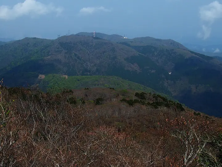
Mount Norikura (865 m) — distinct from the famous Norikura peak in the Northern Alps — straddles the border of Tsuruga (Fukui) and Takashima (Shiga) on the Central Watershed dividing Japan into Pacific and Japan-Sea drainages. It lies along the northern part of the 80-km Takashima Trail near Arachi-goe Pass, with a second-class triangulation point at the summit offering views over Wakasa Bay and toward Lake Biwa. The peak is included in the Omi 100 Mountains and the Takashima Trail.
Mount Norikura at a glance
- Weather: The most settled day in the next 7 days is Wed, November 4: clear, gusts up to 7 m/s. Fri, Nov 6, Sat, Nov 7: strong wind (gusts up to 18 m/s).
Mount Norikura weather (hourly, 14 days)
Sunrise today 06:19, sunset 17:00
| Tue, 11/3 | Wed, 11/4 | Thu, 11/5 | Fri, 11/6 | Sat, 11/7 | Sun, 11/8 | Mon, 11/9 | Tue, 11/10 | Wed, 11/11 | Thu, 11/12 | Fri, 11/13 | Sat, 11/14 | Sun, 11/15 | Mon, 11/16 | Tue, 11/17 | |||||||||||||||||||||||||||||||||||||||||||||||||||||||||||||||||||||||
|---|---|---|---|---|---|---|---|---|---|---|---|---|---|---|---|---|---|---|---|---|---|---|---|---|---|---|---|---|---|---|---|---|---|---|---|---|---|---|---|---|---|---|---|---|---|---|---|---|---|---|---|---|---|---|---|---|---|---|---|---|---|---|---|---|---|---|---|---|---|---|---|---|---|---|---|---|---|---|---|---|---|---|---|---|---|
| Japan time | 15 | 17 | 19 | 21 | 23 | 1 | 3 | 5 | 7 | 9 | 11 | 13 | 15 | 18 | 21 | 0 | 3 | 6 | 9 | 12 | 15 | 18 | 21 | 0 | 3 | 6 | 9 | 12 | 15 | 18 | 21 | 0 | 3 | 6 | 9 | 12 | 15 | 18 | 21 | 0 | 3 | 6 | 9 | 12 | 15 | 18 | 21 | 0 | 3 | 6 | 9 | 15 | 21 | 3 | 9 | 15 | 21 | 3 | 9 | 15 | 21 | 3 | 9 | 15 | 21 | 3 | 9 | 15 | 21 | 3 | 9 | 15 | 21 | 3 | 9 | 15 | 21 | 3 | 9 | 15 | 21 | 3 | 9 | 15 | |
 |   | | | | | | |   | | | |   |   | |   |   | |   | | | | | | | |   |   | | | | | | | | | | | | | | | | | |   | | | | | | |   | | | | | | | | | | |   | | | | |  | | | | | | | | | | | | | | | | ||
| Temperature | °C | 14° | 11° | 9° | 8° | 7° | 7° | 6° | 6° | 7° | 11° | 14° | 16° | 15° | 11° | 11° | 10° | 10° | 10° | 12° | 16° | 16° | 13° | 12° | 12° | 12° | 12° | 13° | 16° | 12° | 11° | 9° | 8° | 7° | 6° | 6° | 8° | 8° | 6° | 7° | 7° | 7° | 6° | 8° | 9° | 10° | 8° | 7° | 6° | 6° | 6° | 10° | 10° | 6° | 4° | 8° | 9° | 6° | 6° | 8° | 8° | 7° | 4° | 8° | 10° | 6° | 7° | 8° | 9° | 5° | 3° | 9° | 13° | 6° | 7° | 10° | 12° | 11° | 10° | 12° | 10° | 7° | 5° | 6° | 9° |
| Precipitation | mm | 1.2 | 3.8 | 3.5 | 2.6 | 1.6 | 0.6 | 12 | 2.1 | 2.5 | 0.4 | 1.5 | 0.8 | 0.8 | 0.5 | 0.4 | 1.0 | 1.6 | 1.5 | 1.1 | 0.2 | 0.1 | 1.1 | 0.6 | 1.7 | 4.7 | 3.4 | 0.2 | 0.3 | 2.0 | 3.5 | 7 | 10 | 3.3 | 2.9 | 0.5 | |||||||||||||||||||||||||||||||||||||||||||||||||
| New snow | cm | ||||||||||||||||||||||||||||||||||||||||||||||||||||||||||||||||||||||||||||||||||||
| Snow depth | cm | 0 | 0 | 0 | 0 | 0 | 0 | 0 | 0 | 0 | 0 | 0 | 0 | 0 | 0 | 0 | 0 | 0 | 0 | 0 | 0 | 0 | 0 | 0 | 0 | 0 | 0 | 0 | 0 | 0 | 0 | 0 | 0 | 0 | 0 | 0 | 0 | 0 | 0 | 0 | 0 | 0 | 0 | 0 | 0 | 0 | 0 | 0 | 0 | 0 | 0 | 0 | 0 | 0 | 0 | 0 | 0 | 0 | 0 | 0 | 0 | 0 | 0 | 0 | 0 | 0 | 0 | 0 | 0 | 0 | 0 | 0 | 0 | 0 | 0 | 0 | 0 | 0 | 0 | 0 | 0 | 0 | 0 | 0 | 0 |
| Wind | m/s | 4 | 3 | 3 | 3 | 2 | 2 | 3 | 2 | 2 | 2 | 2 | 1 | 1 | 1 | 1 | 1 | 2 | 0 | 0 | 0 | 0 | 1 | 1 | 2 | 2 | 3 | 3 | 6 | 4 | 5 | 5 | 6 | 6 | 6 | 6 | 6 | 6 | 4 | 4 | 3 | 3 | 2 | 4 | 5 | 4 | 2 | 2 | 1 | 1 | 0 | 2 | 3 | 0 | 1 | 3 | 3 | 3 | 8 | 8 | 7 | 4 | 2 | 2 | 3 | 0 | 1 | 5 | 6 | 3 | 2 | 1 | 3 | 2 | 3 | 3 | 4 | 4 | 1 | 4 | 7 | 6 | 4 | 4 | 3 |
| Wind gusts | m/s | 11 | 11 | 8 | 9 | 9 | 7 | 7 | 8 | 7 | 6 | 6 | 5 | 4 | 3 | 4 | 4 | 8 | 7 | 3 | 4 | 4 | 2 | 4 | 5 | 6 | 8 | 10 | 15 | 16 | 13 | 13 | 15 | 16 | 16 | 16 | 18 | 17 | 16 | 12 | 11 | 10 | 8 | 10 | 13 | 13 | 10 | 7 | 5 | 4 | 4 | 5 | 11 | 8 | 3 | 8 | 11 | 10 | 20 | 22 | 20 | 18 | 11 | 7 | 9 | 8 | 7 | 14 | 17 | 16 | 10 | 7 | 9 | 8 | 7 | 9 | 12 | 11 | 12 | 11 | 18 | 18 | 15 | 12 | 11 |
| Wind dir. | ↓ | ↓ | ↓ | ↓ | ↓ | ↓ | ↓ | ↓ | ↓ | ↓ | ↓ | ↓ | ↓ | ↓ | ↓ | ↓ | ↓ | ↓ | ↓ | ↓ | ↓ | ↓ | ↓ | ↓ | ↓ | ↓ | ↓ | ↓ | ↓ | ↓ | ↓ | ↓ | ↓ | ↓ | ↓ | ↓ | ↓ | ↓ | ↓ | ↓ | ↓ | ↓ | ↓ | ↓ | ↓ | ↓ | ↓ | ↓ | ↓ | ↓ | ↓ | ↓ | ↓ | ↓ | ↓ | ↓ | ↓ | ↓ | ↓ | ↓ | ↓ | ↓ | ↓ | ↓ | ↓ | ↓ | ↓ | ↓ | ↓ | ↓ | ↓ | ↓ | ↓ | ↓ | ↓ | ↓ | ↓ | ↓ | ↓ | ↓ | ↓ | ↓ | ↓ | ||
Lists that include Mount Norikura
Mount Norikura facts
- Elevation
- 865 m
- Location
- Takashima, Shiga / Tsuruga, Fukui
35.532506, 136.077315 - Website
- takashima-trail.jp
- Trail Map
- takashima-trail.jp
- Wikipedia
- ja.wikipedia.org