
Mount Ōmikage
大御影山
Mihama, Fukui / Takashima, Shiga · Elevation 950 m
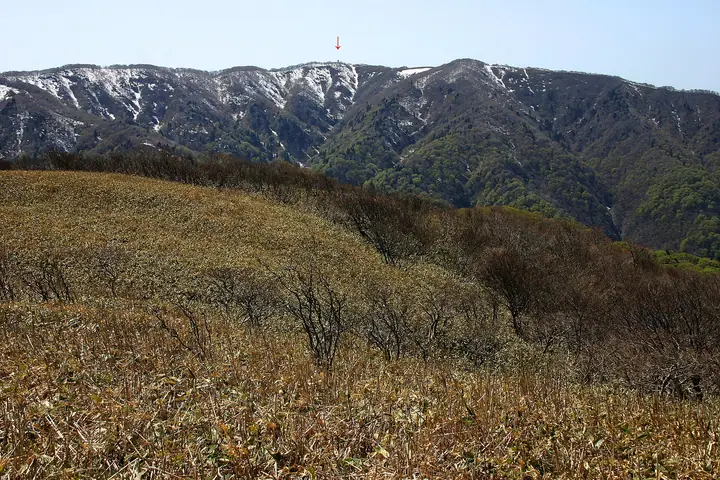
Mount Ōmikage (950 m) lies on the border between Takashima City in Shiga Prefecture and Mihama Town in Mikata District, Fukui Prefecture, and is regarded as the highest peak of the Reinan area. It serves as the headline summit of Course 5 ("Birades to Ōmikage to Mieha to Ochiai") in the 12-section Takashima Trail along the central watershed, and is listed in the 100 Mountains of Hokuriku, Ōmi Hyakuzan, and the Shiga and Fukui prefectural mountain guides.
Mount Ōmikage at a glance
- Weather: The most settled day in the next 7 days is Wed, November 4: clear, gusts up to 7 m/s. Fri, Nov 6, Sat, Nov 7: strong wind (gusts up to 17 m/s).
- Route: The shortest is Takashima Trail from Villadest Imazu to Omikageyama, the Highest Peak of Reinan, and Back: about 7 h 32 min, 14.0 km, about 710 m of climbing.
Mount Ōmikage weather (hourly, 14 days)
Sunrise today 06:19, sunset 17:01
| Tue, 11/3 | Wed, 11/4 | Thu, 11/5 | Fri, 11/6 | Sat, 11/7 | Sun, 11/8 | Mon, 11/9 | Tue, 11/10 | Wed, 11/11 | Thu, 11/12 | Fri, 11/13 | Sat, 11/14 | Sun, 11/15 | Mon, 11/16 | Tue, 11/17 | |||||||||||||||||||||||||||||||||||||||||||||||||||||||||||||||||||||||
|---|---|---|---|---|---|---|---|---|---|---|---|---|---|---|---|---|---|---|---|---|---|---|---|---|---|---|---|---|---|---|---|---|---|---|---|---|---|---|---|---|---|---|---|---|---|---|---|---|---|---|---|---|---|---|---|---|---|---|---|---|---|---|---|---|---|---|---|---|---|---|---|---|---|---|---|---|---|---|---|---|---|---|---|---|---|
| Japan time | 15 | 17 | 19 | 21 | 23 | 1 | 3 | 5 | 7 | 9 | 11 | 13 | 15 | 18 | 21 | 0 | 3 | 6 | 9 | 12 | 15 | 18 | 21 | 0 | 3 | 6 | 9 | 12 | 15 | 18 | 21 | 0 | 3 | 6 | 9 | 12 | 15 | 18 | 21 | 0 | 3 | 6 | 9 | 12 | 15 | 18 | 21 | 0 | 3 | 6 | 9 | 15 | 21 | 3 | 9 | 15 | 21 | 3 | 9 | 15 | 21 | 3 | 9 | 15 | 21 | 3 | 9 | 15 | 21 | 3 | 9 | 15 | 21 | 3 | 9 | 15 | 21 | 3 | 9 | 15 | 21 | 3 | 9 | 15 | |
 |   |   |  | | | | | | | | |   |   | |   | | |   | | |   | | | | | |   | | | | | | | |   | |   | | | | |   | | |   | | | | | | | | | | | | | | | | | | | | | | | |  | | | | | | | | | | | | | | | ||
| Temperature | °C | 12° | 10° | 8° | 7° | 6° | 6° | 5° | 5° | 5° | 10° | 12° | 13° | 13° | 9° | 9° | 8° | 9° | 8° | 10° | 15° | 14° | 11° | 11° | 11° | 11° | 10° | 11° | 15° | 10° | 10° | 8° | 7° | 6° | 5° | 5° | 6° | 6° | 5° | 6° | 6° | 6° | 6° | 6° | 8° | 8° | 6° | 6° | 5° | 5° | 4° | 8° | 9° | 4° | 3° | 7° | 7° | 5° | 5° | 7° | 7° | 6° | 3° | 7° | 8° | 5° | 5° | 7° | 7° | 5° | 1° | 7° | 11° | 5° | 6° | 9° | 11° | 9° | 8° | 10° | 9° | 6° | 4° | 5° | 8° |
| Precipitation | mm | 1.4 | 2.8 | 2.4 | 2.8 | 1.7 | 0.2 | 13 | 2.8 | 2.7 | 0.3 | 1.7 | 1.0 | 0.7 | 0.4 | 0.4 | 0.8 | 1.7 | 1.8 | 1.8 | 0.3 | 0.1 | 1.4 | 0.9 | 0.2 | 1.9 | 4.7 | 3.7 | 0.3 | 0.4 | 0.2 | 2.4 | 4.6 | 0.1 | 0.1 | 6 | 9 | 3.9 | 3.8 | 1.0 | |||||||||||||||||||||||||||||||||||||||||||||
| New snow | cm | ||||||||||||||||||||||||||||||||||||||||||||||||||||||||||||||||||||||||||||||||||||
| Snow depth | cm | 0 | 0 | 0 | 0 | 0 | 0 | 0 | 0 | 0 | 0 | 0 | 0 | 0 | 0 | 0 | 0 | 0 | 0 | 0 | 0 | 0 | 0 | 0 | 0 | 0 | 0 | 0 | 0 | 0 | 0 | 0 | 0 | 0 | 0 | 0 | 0 | 0 | 0 | 0 | 0 | 0 | 0 | 0 | 0 | 0 | 0 | 0 | 0 | 0 | 0 | 0 | 0 | 0 | 0 | 0 | 0 | 0 | 0 | 0 | 0 | 0 | 0 | 0 | 0 | 0 | 0 | 0 | 0 | 0 | 0 | 0 | 0 | 0 | 0 | 0 | 0 | 0 | 0 | 0 | 0 | 0 | 0 | 0 | 0 |
| Wind | m/s | 4 | 3 | 3 | 3 | 2 | 1 | 2 | 2 | 1 | 2 | 2 | 1 | 1 | 0 | 1 | 1 | 1 | 1 | 0 | 1 | 1 | 1 | 1 | 1 | 3 | 3 | 4 | 6 | 5 | 6 | 6 | 7 | 7 | 7 | 6 | 6 | 6 | 5 | 5 | 4 | 4 | 3 | 3 | 4 | 4 | 2 | 1 | 0 | 0 | 0 | 1 | 3 | 2 | 1 | 3 | 4 | 5 | 9 | 8 | 7 | 4 | 2 | 1 | 3 | 1 | 3 | 5 | 7 | 3 | 1 | 1 | 2 | 3 | 3 | 4 | 5 | 5 | 2 | 5 | 7 | 6 | 4 | 4 | 3 |
| Wind gusts | m/s | 10 | 10 | 8 | 9 | 8 | 7 | 6 | 7 | 7 | 6 | 6 | 6 | 5 | 4 | 4 | 4 | 7 | 5 | 3 | 4 | 4 | 3 | 3 | 4 | 7 | 9 | 11 | 15 | 17 | 15 | 15 | 17 | 17 | 17 | 16 | 17 | 16 | 15 | 13 | 12 | 11 | 10 | 9 | 12 | 12 | 9 | 6 | 5 | 3 | 3 | 5 | 11 | 9 | 5 | 8 | 12 | 12 | 21 | 22 | 20 | 18 | 11 | 6 | 8 | 7 | 8 | 14 | 17 | 16 | 9 | 6 | 8 | 8 | 9 | 11 | 13 | 13 | 13 | 12 | 19 | 19 | 15 | 10 | 10 |
| Wind dir. | ↓ | ↓ | ↓ | ↓ | ↓ | ↓ | ↓ | ↓ | ↓ | ↓ | ↓ | ↓ | ↓ | ↓ | ↓ | ↓ | ↓ | ↓ | ↓ | ↓ | ↓ | ↓ | ↓ | ↓ | ↓ | ↓ | ↓ | ↓ | ↓ | ↓ | ↓ | ↓ | ↓ | ↓ | ↓ | ↓ | ↓ | ↓ | ↓ | ↓ | ↓ | ↓ | ↓ | ↓ | ↓ | ↓ | ↓ | ↓ | ↓ | ↓ | ↓ | ↓ | ↓ | ↓ | ↓ | ↓ | ↓ | ↓ | ↓ | ↓ | ↓ | ↓ | ↓ | ↓ | ↓ | ↓ | ↓ | ↓ | ↓ | ↓ | ↓ | ↓ | ↓ | ↓ | ↓ | ↓ | ↓ | ↓ | ↓ | ↓ | ↓ | ↓ | ↓ | ↓ | |
Mount Ōmikage hiking routes
Hiking times are estimates calculated from the terrain.
Lists that include Mount Ōmikage
100 Mountains of Hokuriku · Omi 100 Mountains · Takashima Trail
Mount Ōmikage facts
- Elevation
- 950 m
- Location
- Mihama, Fukui / Takashima, Shiga
35.500470, 135.972161 - Website
- takashima-trail.jp
- Access Information
- takashima-trail.jp
- Wikipedia
- ja.wikipedia.org