
Mount Yotei
羊蹄山
Kutchan, Hokkaido · Elevation 1,898 m
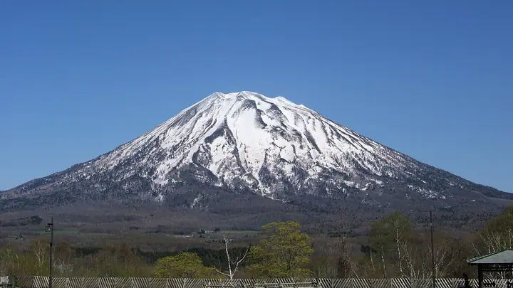
Mount Yotei is a 1,898 m isolated stratovolcano in the Shiribeshi region of southwestern Hokkaido, known as Ezo Fuji for its symmetrical cone resembling Mount Fuji. This representative Hokkaido peak lies at the western edge of Shikotsu-Toya National Park, with four trails from Kutchan, Makkari, Kyogoku and Kimobetsu. The summit has a crater 700 m across, and no fumarolic activity is currently observed.
Mount Yotei at a glance
- Weather: The most settled day in the next 7 days is Thu, November 5: clear, gusts up to 8 m/s. Fri, Nov 6, Sat, Nov 7, Sun, Nov 8: strong wind (gusts up to 20 m/s).
- Route: The shortest is Mount Yotei via the Kyogoku Trail: about 7 h 20 min, 10.2 km, about 1,490 m of climbing.
Mount Yotei weather (hourly, 14 days)
Sunrise today 06:12, sunset 16:28
| Tue, 11/3 | Wed, 11/4 | Thu, 11/5 | Fri, 11/6 | Sat, 11/7 | Sun, 11/8 | Mon, 11/9 | Tue, 11/10 | Wed, 11/11 | Thu, 11/12 | Fri, 11/13 | Sat, 11/14 | Sun, 11/15 | Mon, 11/16 | Tue, 11/17 | |||||||||||||||||||||||||||||||||||||||||||||||||||||||||||||||||||||||
|---|---|---|---|---|---|---|---|---|---|---|---|---|---|---|---|---|---|---|---|---|---|---|---|---|---|---|---|---|---|---|---|---|---|---|---|---|---|---|---|---|---|---|---|---|---|---|---|---|---|---|---|---|---|---|---|---|---|---|---|---|---|---|---|---|---|---|---|---|---|---|---|---|---|---|---|---|---|---|---|---|---|---|---|---|---|
| Japan time | 15 | 17 | 19 | 21 | 23 | 1 | 3 | 5 | 7 | 9 | 11 | 13 | 15 | 18 | 21 | 0 | 3 | 6 | 9 | 12 | 15 | 18 | 21 | 0 | 3 | 6 | 9 | 12 | 15 | 18 | 21 | 0 | 3 | 6 | 9 | 12 | 15 | 18 | 21 | 0 | 3 | 6 | 9 | 12 | 15 | 18 | 21 | 0 | 3 | 6 | 9 | 15 | 21 | 3 | 9 | 15 | 21 | 3 | 9 | 15 | 21 | 3 | 9 | 15 | 21 | 3 | 9 | 15 | 21 | 3 | 9 | 15 | 21 | 3 | 9 | 15 | 21 | 3 | 9 | 15 | 21 | 3 | 9 | 15 | |
  |   | |   |   | |   |   | | |   |  | |  | | | | | | | |   |   |   | | |   |   | |   |   | | | |   | | | | | | | | | | | | | | | | |   | | | | | | |   | | | | | | | | | | | | | | | | | | | |   | | | |   | | ||
| Temperature | °C | -6° | -9° | -9° | -10° | -9° | -9° | -9° | -8° | -8° | -7° | -5° | -5° | -4° | -10° | -11° | -11° | -11° | -9° | -2° | 2° | 2° | -3° | -3° | -3° | -2° | -2° | 1° | 3° | -1° | -5° | -9° | -11° | -11° | -12° | -11° | -11° | -11° | -11° | -11° | -11° | -12° | -12° | -11° | -10° | -10° | -11° | -11° | -11° | -12° | -13° | -10° | -11° | -15° | -13° | -11° | -10° | -15° | -13° | -10° | -7° | -12° | -13° | -9° | -8° | -11° | -13° | -13° | -11° | -12° | -13° | -9° | -7° | -13° | -9° | -5° | -4° | -6° | -6° | -8° | -9° | -12° | -14° | -8° | -8° |
| Precipitation | mm | 0.2 | 2.1 | 3.2 | 1.4 | 0.2 | 2.7 | 3.3 | 0.9 | 0.3 | 0.3 | 2.0 | 0.1 | 0.8 | 1.3 | 1.0 | 1.5 | 1.4 | 1.9 | 1.9 | 2.1 | 1.2 | 1.7 | 1.4 | 1.8 | 2.3 | 1.9 | 1.1 | 0.7 | 0.2 | 0.2 | 0.2 | 0.2 | 0.2 | 0.6 | 0.3 | 0.9 | 1.0 | 0.5 | 0.6 | 0.1 | 0.1 | 0.1 | 0.1 | 0.6 | 0.3 | 1.4 | 2.2 | 4.1 | 1.1 | 0.1 | ||||||||||||||||||||||||||||||||||
| New snow | cm | <.1 | 0.1 | 1.9 | 2.9 | 0.6 | 0.4 | 1.3 | 1.0 | 1.5 | 1.4 | 1.8 | 1.9 | 2.1 | 1.2 | 1.7 | 1.4 | 1.8 | 2.3 | 1.9 | 1.1 | 0.7 | 0.2 | 0.2 | 0.2 | 0.2 | <.1 | 0.2 | <.1 | 0.6 | 0.3 | 0.9 | 1.0 | 0.5 | 0.5 | <.1 | <.1 | 0.1 | <.1 | 0.2 | 0.4 | <.1 | 0.2 | ||||||||||||||||||||||||||||||||||||||||||
| Snow depth | cm | <1 | 0 | <1 | <1 | 2 | 4 | 4 | 4 | 3 | 3 | 3 | 2 | 2 | 1 | 1 | 1 | 1 | 1 | 1 | 1 | <1 | <1 | <1 | <1 | 0 | 0 | 0 | 0 | 0 | 0 | 0 | 1 | 1 | 3 | 4 | 5 | 6 | 7 | 7 | 8 | 9 | 10 | 11 | 12 | 12 | 12 | 13 | 12 | 13 | 12 | 12 | 12 | 12 | 12 | 12 | 12 | 12 | 13 | 13 | 12 | 12 | 12 | 12 | 12 | 12 | 12 | 12 | 12 | 11 | 11 | 11 | 11 | 11 | 10 | 10 | 7 | 6 | 5 | 5 | 4 | 4 | 4 | 4 | 4 |
| Wind | m/s | 4 | 1 | 1 | 1 | 1 | 1 | 1 | 3 | 4 | 4 | 2 | 1 | 0 | 1 | 1 | 2 | 1 | 2 | 2 | 2 | 1 | 1 | 1 | 1 | 1 | 1 | 2 | 4 | 5 | 4 | 4 | 4 | 4 | 4 | 5 | 4 | 4 | 6 | 5 | 5 | 5 | 5 | 5 | 6 | 4 | 3 | 3 | 1 | 1 | 1 | 3 | 3 | 1 | 0 | 0 | 1 | 1 | 1 | 1 | 2 | 1 | 1 | 1 | 2 | 3 | 2 | 5 | 4 | 1 | 1 | 0 | 1 | 1 | 2 | 1 | 1 | 1 | 0 | 3 | 4 | 3 | 2 | 2 | 1 |
| Wind gusts | m/s | 15 | 13 | 7 | 7 | 8 | 10 | 9 | 13 | 15 | 15 | 14 | 9 | 6 | 5 | 6 | 6 | 7 | 7 | 7 | 8 | 8 | 5 | 6 | 8 | 8 | 7 | 10 | 14 | 18 | 18 | 15 | 19 | 16 | 15 | 20 | 20 | 18 | 21 | 21 | 20 | 20 | 19 | 18 | 18 | 18 | 15 | 12 | 10 | 7 | 7 | 11 | 12 | 10 | 5 | 4 | 6 | 7 | 6 | 6 | 10 | 7 | 4 | 5 | 12 | 10 | 10 | 16 | 16 | 12 | 8 | 5 | 5 | 4 | 7 | 8 | 8 | 8 | 7 | 10 | 15 | 15 | 11 | 9 | 9 |
| Wind dir. | ↓ | ↓ | ↓ | ↓ | ↓ | ↓ | ↓ | ↓ | ↓ | ↓ | ↓ | ↓ | ↓ | ↓ | ↓ | ↓ | ↓ | ↓ | ↓ | ↓ | ↓ | ↓ | ↓ | ↓ | ↓ | ↓ | ↓ | ↓ | ↓ | ↓ | ↓ | ↓ | ↓ | ↓ | ↓ | ↓ | ↓ | ↓ | ↓ | ↓ | ↓ | ↓ | ↓ | ↓ | ↓ | ↓ | ↓ | ↓ | ↓ | ↓ | ↓ | ↓ | ↓ | ↓ | ↓ | ↓ | ↓ | ↓ | ↓ | ↓ | ↓ | ↓ | ↓ | ↓ | ↓ | ↓ | ↓ | ↓ | ↓ | ↓ | ↓ | ↓ | ↓ | ↓ | ↓ | ↓ | ↓ | ↓ | ↓ | ↓ | ↓ | ↓ | ↓ | ↓ | |
Mount Yotei live cameras
Mount Yotei hiking routes
- Mount Yotei via the Kyogoku Trail 10.2 km · Ascent 1,494 m 京極登山口, 京極登山口駐車場
- Mount Yotei Kimobetsu Peak Round Trip via the Kimobetsu Trail 10.4 km · Ascent 1,528 m 喜茂別登山口
- Mount Yotei via the Kutchan Hirafu Trail 12.7 km · Ascent 1,616 m 比羅夫登山口 (parking)
- Mount Yōtei via the Makkari Trail and Crater Rim 14.4 km · Ascent 1,637 m parking
Hiking times are estimates calculated from the terrain.
Huts, campsites and lodging near Mount Yotei
Mountain huts
Campsites
- 羊蹄山自然公園真狩キャンプ場
- 羊蹄山半月湖野営場
Lists that include Mount Yotei
100 Famous Japanese Mountains · Japan 200 Famous Mountains · Japan's 300 Famous Mountains · 100 Famous Mountains with First-order Triangulation Points · New Japan 100 Famous Mountains · Illustrated Collection of Japan's Famous Mountains · 100 Fujis of Japan · Hokkaido 100 Famous Mountains · Elevations of 1003 Mountains of Japan · 1000 Mountains of Japan
Mount Yotei facts
- Also known as
- マッカリヌプリ · 後方羊蹄山 · 真狩岳 · 蝦夷富士 · Ezo Fuji
- Elevation
- 1,898 m
- Location
- Kutchan, Hokkaido
42.826667, 140.811389 - National Park
- 支笏洞爺国立公園
- Volcano
- Active volcano (羊蹄山)
- Website
- www.town.kutchan.hokkaido.jp
- Trail Map
- www.town.kutchan.hokkaido.jp (PDF)
- Access Information
- www.town.kutchan.hokkaido.jp
- Wikipedia
- ja.wikipedia.org