
Mount Shiribetsu
尻別岳
Kimobetsu, Hokkaido · Elevation 1,107 m
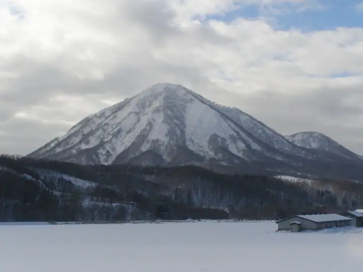
Mount Shiribetsu is a 1,107.3 m Quaternary stratovolcano of andesite and dacite straddling the borders of Kimobetsu Town, Rusutsu Village, and Makkari Village in Hokkaido. Its Ainu name, Pinne-shiri ('male peak'), pairs it with Mount Yōtei's Macne-shiri ('female peak') as a husband-and-wife mountain, and early Japanese settlers also called it 'Maeyōtei' (anterior Yōtei). Major explosive eruptions occurred about 130,000 and 70,000 years ago, and a sector collapse 50,000–60,000 years ago produced a debris avalanche stretching 10 km westward, but no Holocene activity is known. The Rusutsu Course on the south and the Kimobetsu Course on the north both reach the summit in about two hours; the mountain is one of the 100 Famous Mountains of Hokkaido.
Mount Shiribetsu at a glance
- Weather: The most settled day in the next 7 days is Thu, November 5: clear, gusts up to 6 m/s. Fri, Nov 6, Sat, Nov 7, Sun, Nov 8: strong wind (gusts up to 19 m/s).
- Route: The shortest is Mount Shiribetsu Return via the Rusutsu Route: about 4 h 5 min, 6.4 km, about 610 m of climbing.
Mount Shiribetsu weather (hourly, 14 days)
Sunrise today 06:12, sunset 16:28
| Tue, 11/3 | Wed, 11/4 | Thu, 11/5 | Fri, 11/6 | Sat, 11/7 | Sun, 11/8 | Mon, 11/9 | Tue, 11/10 | Wed, 11/11 | Thu, 11/12 | Fri, 11/13 | Sat, 11/14 | Sun, 11/15 | Mon, 11/16 | Tue, 11/17 | |||||||||||||||||||||||||||||||||||||||||||||||||||||||||||||||||||||||
|---|---|---|---|---|---|---|---|---|---|---|---|---|---|---|---|---|---|---|---|---|---|---|---|---|---|---|---|---|---|---|---|---|---|---|---|---|---|---|---|---|---|---|---|---|---|---|---|---|---|---|---|---|---|---|---|---|---|---|---|---|---|---|---|---|---|---|---|---|---|---|---|---|---|---|---|---|---|---|---|---|---|---|---|---|---|
| Japan time | 15 | 17 | 19 | 21 | 23 | 1 | 3 | 5 | 7 | 9 | 11 | 13 | 15 | 18 | 21 | 0 | 3 | 6 | 9 | 12 | 15 | 18 | 21 | 0 | 3 | 6 | 9 | 12 | 15 | 18 | 21 | 0 | 3 | 6 | 9 | 12 | 15 | 18 | 21 | 0 | 3 | 6 | 9 | 12 | 15 | 18 | 21 | 0 | 3 | 6 | 9 | 15 | 21 | 3 | 9 | 15 | 21 | 3 | 9 | 15 | 21 | 3 | 9 | 15 | 21 | 3 | 9 | 15 | 21 | 3 | 9 | 15 | 21 | 3 | 9 | 15 | 21 | 3 | 9 | 15 | 21 | 3 | 9 | 15 | |
  |   | | |   |   |   |   |   | | |  | |  | | | | | | | |   |   |   | | |   |   |   |   |   |   |   | |   | |   | | | | | | | | | | | | | | | | | |   | | | | | | | | | | | | | | | | | | | | | | | |   | | | | |   | ||
| Temperature | °C | -1° | -4° | -4° | -4° | -4° | -4° | -3° | -3° | -3° | -2° | 0° | 1° | 1° | -4° | -5° | -5° | -4° | -3° | 4° | 7° | 7° | 2° | 3° | 3° | 4° | 4° | 6° | 8° | 4° | 0° | -3° | -6° | -7° | -7° | -6° | -6° | -6° | -6° | -7° | -7° | -7° | -7° | -6° | -5° | -5° | -6° | -6° | -6° | -7° | -7° | -6° | -6° | -9° | -8° | -6° | -4° | -9° | -8° | -5° | -2° | -8° | -8° | -4° | -3° | -7° | -8° | -8° | -7° | -7° | -8° | -4° | -2° | -7° | -3° | 1° | 1° | -1° | -1° | -3° | -4° | -8° | -9° | -4° | -3° |
| Precipitation | mm | 0.8 | 3.6 | 0.6 | 0.1 | 3.9 | 2.9 | 0.7 | 0.7 | 0.1 | 2.3 | 0.7 | 0.6 | 0.8 | 0.3 | 0.7 | 0.8 | 1.2 | 1.2 | 1.4 | 1.0 | 1.4 | 1.0 | 1.4 | 1.3 | 1.2 | 0.6 | 0.8 | 0.3 | 0.1 | 0.1 | 0.1 | 0.1 | 0.1 | 0.3 | 0.3 | 1.5 | 1.1 | 0.2 | 0.4 | 0.1 | 0.1 | 0.1 | 0.3 | 0.5 | 1.3 | 1.0 | 3.4 | 1.1 | ||||||||||||||||||||||||||||||||||||
| New snow | cm | 0.6 | 2.9 | 0.3 | 0.4 | 0.8 | 0.4 | 0.7 | 0.8 | 1.2 | 1.2 | 1.5 | 1.0 | 1.4 | 1.0 | 1.4 | 1.3 | 1.2 | 0.6 | 0.8 | 0.3 | 0.1 | 0.1 | 0.1 | 0.1 | 0.1 | 0.3 | 0.3 | 1.5 | 1.2 | 0.3 | 0.3 | <.1 | 0.1 | 0.1 | 0.3 | 0.5 | <.1 | |||||||||||||||||||||||||||||||||||||||||||||||
| Snow depth | cm | <1 | <1 | <1 | <1 | <1 | 2 | 2 | 2 | 2 | 2 | 2 | 2 | 1 | 1 | 1 | 1 | 1 | 1 | 1 | <1 | <1 | <1 | <1 | 0 | 0 | 0 | 0 | 0 | 0 | 0 | 0 | <1 | <1 | 1 | 2 | 3 | 3 | 4 | 5 | 5 | 6 | 7 | 8 | 8 | 8 | 9 | 9 | 8 | 8 | 9 | 8 | 8 | 8 | 8 | 8 | 8 | 8 | 9 | 10 | 10 | 9 | 9 | 9 | 9 | 9 | 9 | 9 | 9 | 9 | 9 | 9 | 8 | 8 | 8 | 7 | 6 | 5 | 3 | 3 | 3 | 3 | 3 | 3 | 2 |
| Wind | m/s | 5 | 2 | 2 | 1 | 1 | 2 | 2 | 3 | 3 | 4 | 3 | 1 | 1 | 1 | 1 | 1 | 1 | 2 | 2 | 2 | 1 | 2 | 2 | 2 | 2 | 1 | 3 | 5 | 5 | 5 | 5 | 5 | 4 | 5 | 7 | 7 | 5 | 5 | 5 | 6 | 6 | 6 | 6 | 7 | 5 | 4 | 3 | 3 | 3 | 2 | 4 | 3 | 1 | 0 | 0 | 2 | 1 | 1 | 1 | 2 | 1 | 0 | 1 | 3 | 2 | 2 | 5 | 4 | 1 | 1 | 0 | 0 | 1 | 1 | 1 | 1 | 1 | 1 | 3 | 5 | 3 | 2 | 1 | 2 |
| Wind gusts | m/s | 13 | 11 | 6 | 5 | 5 | 7 | 8 | 8 | 9 | 11 | 11 | 8 | 5 | 3 | 3 | 3 | 4 | 4 | 5 | 6 | 6 | 5 | 5 | 5 | 6 | 6 | 7 | 12 | 15 | 14 | 13 | 15 | 13 | 12 | 17 | 19 | 17 | 16 | 15 | 15 | 15 | 15 | 16 | 17 | 17 | 13 | 10 | 8 | 7 | 7 | 10 | 11 | 9 | 4 | 3 | 5 | 5 | 5 | 4 | 7 | 5 | 3 | 3 | 10 | 8 | 8 | 12 | 12 | 9 | 4 | 3 | 4 | 3 | 4 | 4 | 5 | 5 | 5 | 7 | 12 | 12 | 8 | 7 | 7 |
| Wind dir. | ↓ | ↓ | ↓ | ↓ | ↓ | ↓ | ↓ | ↓ | ↓ | ↓ | ↓ | ↓ | ↓ | ↓ | ↓ | ↓ | ↓ | ↓ | ↓ | ↓ | ↓ | ↓ | ↓ | ↓ | ↓ | ↓ | ↓ | ↓ | ↓ | ↓ | ↓ | ↓ | ↓ | ↓ | ↓ | ↓ | ↓ | ↓ | ↓ | ↓ | ↓ | ↓ | ↓ | ↓ | ↓ | ↓ | ↓ | ↓ | ↓ | ↓ | ↓ | ↓ | ↓ | ↓ | ↓ | ↓ | ↓ | ↓ | ↓ | ↓ | ↓ | ↓ | ↓ | ↓ | ↓ | ↓ | ↓ | ↓ | ↓ | ↓ | ↓ | ↓ | ↓ | ↓ | ↓ | ↓ | ↓ | ↓ | ↓ | ↓ | ↓ | ↓ | ↓ | ↓ | |
Mount Shiribetsu hiking routes
Hiking times are estimates calculated from the terrain.
Huts, campsites and lodging near Mount Shiribetsu
Campsites
- ルスツふるさと公園キャンプ場
- Rusan Campsite
Lodging
- Hotel Romulus
- Clydesdale Pension
- The Vale Rusutsu
- Rusutsu Hotel
- Rusutsu Lodges
Lists that include Mount Shiribetsu
Hokkaido 100 Famous Mountains · Elevations of 1003 Mountains of Japan · 1000 Mountains of Japan
Mount Shiribetsu facts
- Also known as
- ピンネシリ · 前方羊蹄山
- Elevation
- 1,107 m
- Location
- Kimobetsu, Hokkaido
42.772463, 140.910553 - Season Opens
- May 29
- Season Closes
- October 31
- Website
- www.vill.rusutsu.lg.jp
- Access Information
- www.vill.rusutsu.lg.jp (PDF)
- Wikipedia
- ja.wikipedia.org