
Mount Unzen
雲仙岳
Unzen, Nagasaki · Elevation 1,359 m
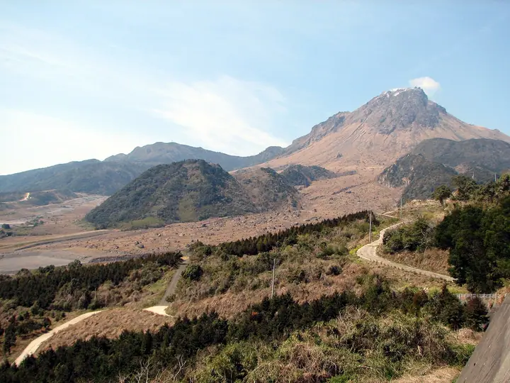
Mount Unzen is an active volcanic complex in the centre of Nagasaki Prefecture’s Shimabara Peninsula, at the heart of Unzen-Amakusa, Japan’s first national park. It includes the older lava domes of Fugendake (1,359 m), Kunimidake and Myokendake, and its highest summit, Heisei Shinzan (1,483 m), formed during the 1990–1995 eruptions. Hiking trails start at Nita Pass.
Mount Unzen at a glance
- Weather: The most settled day in the next 7 days is Wed, November 4: clear, gusts up to 11 m/s. Thu, Nov 5: strong wind (gusts up to 16 m/s).
- Route: The shortest is Mount Tateiwa and Mount Fugen Circuit from Nita Pass: about 3 h 7 min, 5.4 km, about 450 m of climbing.
Mount Unzen weather (hourly, 14 days)
Sunrise today 06:38, sunset 17:27
| Tue, 11/3 | Wed, 11/4 | Thu, 11/5 | Fri, 11/6 | Sat, 11/7 | Sun, 11/8 | Mon, 11/9 | Tue, 11/10 | Wed, 11/11 | Thu, 11/12 | Fri, 11/13 | Sat, 11/14 | Sun, 11/15 | Mon, 11/16 | Tue, 11/17 | |||||||||||||||||||||||||||||||||||||||||||||||||||||||||||||||||||||||
|---|---|---|---|---|---|---|---|---|---|---|---|---|---|---|---|---|---|---|---|---|---|---|---|---|---|---|---|---|---|---|---|---|---|---|---|---|---|---|---|---|---|---|---|---|---|---|---|---|---|---|---|---|---|---|---|---|---|---|---|---|---|---|---|---|---|---|---|---|---|---|---|---|---|---|---|---|---|---|---|---|---|---|---|---|---|
| Japan time | 15 | 17 | 19 | 21 | 23 | 1 | 3 | 5 | 7 | 9 | 11 | 13 | 15 | 18 | 21 | 0 | 3 | 6 | 9 | 12 | 15 | 18 | 21 | 0 | 3 | 6 | 9 | 12 | 15 | 18 | 21 | 0 | 3 | 6 | 9 | 12 | 15 | 18 | 21 | 0 | 3 | 6 | 9 | 12 | 15 | 18 | 21 | 0 | 3 | 6 | 9 | 15 | 21 | 3 | 9 | 15 | 21 | 3 | 9 | 15 | 21 | 3 | 9 | 15 | 21 | 3 | 9 | 15 | 21 | 3 | 9 | 15 | 21 | 3 | 9 | 15 | 21 | 3 | 9 | 15 | 21 | 3 | 9 | 15 | |
  | |   |   | | | | | |   | | | |   | |   | |   |   |   | |   | | | |  |  | | | | | | | | | | | | | | | | | | | | | | |   | | | | | | | | |   | | | | | |  | | | | | | | | | | | | | | | | |  | | | ||
| Temperature | °C | 12° | 12° | 11° | 11° | 10° | 10° | 10° | 9° | 9° | 10° | 12° | 13° | 14° | 12° | 11° | 11° | 11° | 10° | 12° | 13° | 14° | 14° | 12° | 11° | 10° | 9° | 11° | 13° | 12° | 8° | 6° | 6° | 5° | 4° | 5° | 7° | 8° | 6° | 5° | 5° | 5° | 5° | 7° | 9° | 9° | 8° | 8° | 8° | 8° | 8° | 9° | 11° | 7° | 5° | 7° | 9° | 5° | 6° | 6° | 8° | 5° | 4° | 6° | 9° | 6° | 5° | 8° | 11° | 8° | 6° | 8° | 12° | 9° | 10° | 12° | 12° | 11° | 10° | 11° | 13° | 9° | 7° | 7° | 11° |
| Precipitation | mm | 1.2 | 1.8 | 0.3 | 0.2 | 9 | 3.5 | 2.1 | 0.2 | 0.2 | 0.1 | 0.8 | 14 | 4.6 | 0.1 | ||||||||||||||||||||||||||||||||||||||||||||||||||||||||||||||||||||||
| New snow | cm | ||||||||||||||||||||||||||||||||||||||||||||||||||||||||||||||||||||||||||||||||||||
| Snow depth | cm | 0 | 0 | 0 | 0 | 0 | 0 | 0 | 0 | 0 | 0 | 0 | 0 | 0 | 0 | 0 | 0 | 0 | 0 | 0 | 0 | 0 | 0 | 0 | 0 | 0 | 0 | 0 | 0 | 0 | 0 | 0 | 0 | 0 | 0 | 0 | 0 | 0 | 0 | 0 | 0 | 0 | 0 | 0 | 0 | 0 | 0 | 0 | 0 | 0 | 0 | 0 | 0 | 0 | 0 | 0 | 0 | 0 | 0 | 0 | 0 | 0 | 0 | 0 | 0 | 0 | 0 | 0 | 0 | 0 | 0 | 0 | 0 | 0 | 0 | 0 | 0 | 0 | 0 | 0 | 0 | 0 | 0 | 0 | 0 |
| Wind | m/s | 5 | 4 | 5 | 6 | 5 | 5 | 5 | 4 | 4 | 3 | 2 | 2 | 2 | 1 | 2 | 2 | 2 | 2 | 1 | 3 | 5 | 3 | 2 | 2 | 2 | 2 | 2 | 4 | 5 | 4 | 3 | 4 | 5 | 4 | 4 | 3 | 3 | 4 | 4 | 4 | 4 | 4 | 3 | 2 | 2 | 1 | 1 | 1 | 2 | 3 | 4 | 4 | 3 | 2 | 3 | 5 | 2 | 3 | 5 | 4 | 3 | 1 | 1 | 1 | 2 | 2 | 3 | 4 | 4 | 2 | 2 | 1 | 1 | 1 | 4 | 3 | 0 | 1 | 3 | 4 | 4 | 5 | 5 | 5 |
| Wind gusts | m/s | 13 | 13 | 14 | 15 | 14 | 14 | 13 | 13 | 11 | 10 | 9 | 7 | 5 | 6 | 9 | 5 | 5 | 5 | 6 | 10 | 16 | 15 | 12 | 7 | 8 | 9 | 7 | 11 | 13 | 13 | 10 | 11 | 13 | 13 | 13 | 12 | 10 | 10 | 12 | 11 | 11 | 11 | 10 | 7 | 5 | 4 | 5 | 4 | 6 | 9 | 11 | 12 | 11 | 8 | 9 | 12 | 13 | 10 | 16 | 15 | 12 | 8 | 5 | 5 | 5 | 8 | 9 | 11 | 11 | 10 | 5 | 6 | 5 | 7 | 13 | 16 | 11 | 4 | 8 | 10 | 12 | 14 | 14 | 14 |
| Wind dir. | ↓ | ↓ | ↓ | ↓ | ↓ | ↓ | ↓ | ↓ | ↓ | ↓ | ↓ | ↓ | ↓ | ↓ | ↓ | ↓ | ↓ | ↓ | ↓ | ↓ | ↓ | ↓ | ↓ | ↓ | ↓ | ↓ | ↓ | ↓ | ↓ | ↓ | ↓ | ↓ | ↓ | ↓ | ↓ | ↓ | ↓ | ↓ | ↓ | ↓ | ↓ | ↓ | ↓ | ↓ | ↓ | ↓ | ↓ | ↓ | ↓ | ↓ | ↓ | ↓ | ↓ | ↓ | ↓ | ↓ | ↓ | ↓ | ↓ | ↓ | ↓ | ↓ | ↓ | ↓ | ↓ | ↓ | ↓ | ↓ | ↓ | ↓ | ↓ | ↓ | ↓ | ↓ | ↓ | ↓ | ↓ | ↓ | ↓ | ↓ | ↓ | ↓ | ↓ | ↓ | |
Mount Unzen live cameras
Mount Unzen hiking routes
- Mount Tateiwa and Mount Fugen Circuit from Nita Pass 5.4 km · Ascent 450 m 第一展望所駐車場, 仁田峠駅 (Aerialway station), 雲仙ロープウェイ駅 (Aerialway station)
- Mount Myoken–Mount Kunimi–Mount Fugen Circuit from Nita Pass 6.1 km · Ascent 721 m 雲仙ロープウェイ駅 (Aerialway station), 仁田峠駅 (Aerialway station), 第一展望所駐車場
- Mount Fugen Return via Nita Pass and Tateiwa-no-mine from Ikenohara 7.4 km · Ascent 702 m 池ノ原園地, 雲仙 野岳駐車場
Hiking times are estimates calculated from the terrain.
Huts, campsites and lodging near Mount Unzen
Campsites
- 白雲の池キャンプ場
Lodging
- 雲仙温泉 東園
- 湯元ホテル
- 湯快リゾート 雲仙温泉 雲仙東洋館
- 雲仙いわき旅館
- 界 雲仙
Lists that include Mount Unzen
Japan 200 Famous Mountains · Japan's 300 Famous Mountains · 100 Famous Mountains with First-order Triangulation Points · New Japan 100 Famous Mountains · Illustrated Collection of Japan's Famous Mountains · 100 Famous Hot Spring Mountains · Kyushu 100 Famous Mountains · Elevations of 1003 Mountains of Japan · 1000 Mountains of Japan
Mount Unzen facts
- Also known as
- 温泉(うんぜん)岳 普賢岳 · Unzen-dake
- Elevation
- 1,359 m
- Location
- Unzen, Nagasaki
32.761894, 130.291645 - National Park
- 雲仙天草国立公園
- Volcano
- Active volcano (雲仙岳)
- Website
- www.env.go.jp
- Trail Map
- www.pref.nagasaki.jp (PDF)
- Access Information
- www.shimakanren.com
- Wikipedia
- ja.wikipedia.org