
Mount Tarumae
樽前山
Tomakomai, Hokkaido · Elevation 1,041 m
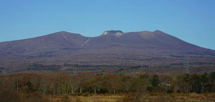
Mount Tarumae is a 1041 m active volcano on the southern shore of Lake Shikotsu in southwestern Hokkaido, with its summit in Tomakomai. It is a triple-structured volcano whose central lava dome formed during the 1909 eruption; the Eastern Peak (1022 m, first-order triangulation point) and Western Peak (994 m) form the outer crater rim. It lies in Shikotsu-Toya National Park. Its Ainu-derived name, taor-oma-i, means high ground beside the river. The Japan Meteorological Agency continuously monitors the volcano, and the area inside the outer rim, including the lava dome, is a designated danger zone closed to entry. A road reaches the seventh-station hut and the outer rim is reachable in about an hour, making it a popular introduction to volcanic hiking. Flowers including iwabukuro bloom from early summer through autumn.
Mount Tarumae at a glance
- Weather: The most settled day in the next 7 days is Thu, November 5: cloudy, gusts up to 4 m/s. Sat, Nov 7: strong wind (gusts up to 21 m/s).
- Route: The shortest is Mount Tarumae Outer Rim Circuit via East and West Peaks: about 4 h 28 min, 7.4 km, about 590 m of climbing.
Mount Tarumae weather (hourly, 14 days)
Sunrise today 06:10, sunset 16:26
| Tue, 11/3 | Wed, 11/4 | Thu, 11/5 | Fri, 11/6 | Sat, 11/7 | Sun, 11/8 | Mon, 11/9 | Tue, 11/10 | Wed, 11/11 | Thu, 11/12 | Fri, 11/13 | Sat, 11/14 | Sun, 11/15 | Mon, 11/16 | Tue, 11/17 | |||||||||||||||||||||||||||||||||||||||||||||||||||||||||||||||||||||||
|---|---|---|---|---|---|---|---|---|---|---|---|---|---|---|---|---|---|---|---|---|---|---|---|---|---|---|---|---|---|---|---|---|---|---|---|---|---|---|---|---|---|---|---|---|---|---|---|---|---|---|---|---|---|---|---|---|---|---|---|---|---|---|---|---|---|---|---|---|---|---|---|---|---|---|---|---|---|---|---|---|---|---|---|---|---|
| Japan time | 21 | 23 | 1 | 3 | 5 | 7 | 9 | 11 | 13 | 15 | 17 | 19 | 21 | 0 | 3 | 6 | 9 | 12 | 15 | 18 | 21 | 0 | 3 | 6 | 9 | 12 | 15 | 18 | 21 | 0 | 3 | 6 | 9 | 12 | 15 | 18 | 21 | 0 | 3 | 6 | 9 | 12 | 15 | 18 | 21 | 0 | 3 | 6 | 9 | 12 | 15 | 21 | 3 | 9 | 15 | 21 | 3 | 9 | 15 | 21 | 3 | 9 | 15 | 21 | 3 | 9 | 15 | 21 | 3 | 9 | 15 | 21 | 3 | 9 | 15 | 21 | 3 | 9 | 15 | 21 | 3 | 9 | 15 | 21 | |
 |   |   | |   |   |  | | | |  | | | | | |   | | |   |   | | | |   |   | |   | |   |   | |   |   | | | | |   | |   | | | | | | | | |   | | | | | |   | | | | | | | | | | | | | | | |  | | |   | | | | | |  | | | | ||
| Temperature | °C | -2° | -2° | -2° | -1° | -1° | -1° | 2° | 3° | 4° | 3° | 0° | -1° | -3° | -3° | -2° | -1° | 5° | 6° | 7° | 5° | 5° | 5° | 5° | 5° | 6° | 9° | 7° | 3° | 0° | -2° | -4° | -5° | -3° | -2° | -3° | -4° | -4° | -4° | -4° | -4° | -3° | -2° | -3° | -4° | -4° | -4° | -4° | -5° | -3° | -2° | -4° | -6° | -6° | -3° | -2° | -4° | -5° | -2° | 0° | -4° | -5° | -1° | 0° | -5° | -6° | -4° | -4° | -5° | -5° | -1° | 0° | -4° | -2° | 2° | 4° | 1° | 2° | 0° | -1° | -5° | -6° | -2° | 0° | -4° |
| Precipitation | mm | 0.2 | 1.7 | 0.4 | 1.2 | 5 | 2.1 | 2.7 | 8 | 0.2 | 0.1 | 0.2 | 0.3 | 0.3 | 0.2 | 0.5 | 0.5 | 0.5 | 0.3 | 0.2 | 0.2 | 0.1 | 1.5 | 0.9 | 0.1 | 0.1 | 0.4 | 2.3 | 2.6 | 1.5 | |||||||||||||||||||||||||||||||||||||||||||||||||||||||
| New snow | cm | <.1 | 0.7 | <.1 | <.1 | 0.3 | <.1 | <.1 | 0.2 | 0.5 | 0.5 | 0.4 | 0.3 | 0.2 | 0.2 | 0.1 | <.1 | <.1 | <.1 | <.1 | 1.5 | 0.9 | <.1 | <.1 | <.1 | ||||||||||||||||||||||||||||||||||||||||||||||||||||||||||||
| Snow depth | cm | 0 | 0 | <1 | <1 | <1 | <1 | <1 | <1 | <1 | <1 | <1 | <1 | <1 | <1 | <1 | <1 | <1 | 0 | 0 | 0 | 0 | 0 | 0 | 0 | 0 | 0 | 0 | 0 | 0 | 0 | 0 | 0 | 0 | <1 | <1 | <1 | <1 | <1 | <1 | <1 | <1 | <1 | <1 | <1 | <1 | <1 | <1 | <1 | <1 | <1 | <1 | <1 | <1 | <1 | <1 | <1 | 2 | 2 | <1 | <1 | <1 | <1 | <1 | <1 | <1 | <1 | <1 | <1 | <1 | <1 | <1 | <1 | <1 | <1 | <1 | <1 | <1 | <1 | 0 | 0 | 0 | 0 | 0 | 0 |
| Wind | m/s | 0 | 0 | 2 | 2 | 4 | 4 | 3 | 2 | 2 | 1 | 0 | 0 | 1 | 1 | 1 | 1 | 1 | 1 | 1 | 1 | 1 | 1 | 0 | 0 | 0 | 3 | 4 | 4 | 5 | 6 | 5 | 5 | 7 | 8 | 5 | 4 | 3 | 4 | 5 | 5 | 5 | 6 | 5 | 3 | 3 | 3 | 2 | 2 | 3 | 3 | 3 | 2 | 1 | 1 | 3 | 4 | 4 | 2 | 1 | 1 | 1 | 1 | 3 | 1 | 2 | 4 | 4 | 2 | 1 | 1 | 1 | 0 | 0 | 1 | 1 | 1 | 0 | 3 | 5 | 5 | 1 | 1 | 3 | 0 |
| Wind gusts | m/s | 6 | 4 | 9 | 8 | 10 | 11 | 10 | 8 | 7 | 7 | 4 | 2 | 3 | 3 | 4 | 4 | 3 | 3 | 4 | 3 | 3 | 4 | 4 | 2 | 2 | 8 | 11 | 13 | 12 | 15 | 15 | 14 | 17 | 21 | 20 | 14 | 11 | 11 | 12 | 13 | 13 | 15 | 15 | 13 | 8 | 7 | 7 | 6 | 8 | 9 | 9 | 9 | 5 | 4 | 7 | 10 | 9 | 9 | 6 | 3 | 4 | 4 | 10 | 7 | 6 | 11 | 11 | 9 | 6 | 4 | 6 | 4 | 3 | 4 | 6 | 5 | 4 | 8 | 12 | 13 | 11 | 6 | 7 | 7 |
| Wind dir. | ↓ | ↓ | ↓ | ↓ | ↓ | ↓ | ↓ | ↓ | ↓ | ↓ | ↓ | ↓ | ↓ | ↓ | ↓ | ↓ | ↓ | ↓ | ↓ | ↓ | ↓ | ↓ | ↓ | ↓ | ↓ | ↓ | ↓ | ↓ | ↓ | ↓ | ↓ | ↓ | ↓ | ↓ | ↓ | ↓ | ↓ | ↓ | ↓ | ↓ | ↓ | ↓ | ↓ | ↓ | ↓ | ↓ | ↓ | ↓ | ↓ | ↓ | ↓ | ↓ | ↓ | ↓ | ↓ | ↓ | ↓ | ↓ | ↓ | ↓ | ↓ | ↓ | ↓ | ↓ | ↓ | ↓ | ↓ | ↓ | ↓ | ↓ | ↓ | ↓ | ↓ | ↓ | ↓ | ↓ | ↓ | ↓ | ↓ | ↓ | ↓ | ↓ | ↓ | ↓ | |
Mount Tarumae live cameras
Mount Tarumae hiking routes
- Mount Tarumae Outer Rim Circuit via East and West Peaks 7.4 km · Ascent 586 m 樽前山七合目登山口 (parking)
- Mount Tarumae Outer Rim Circuit: East, West, and North Peaks 8.5 km · Ascent 652 m 樽前山七合目ヒュッテ (parking)
- Mount Tarumae Crater Rim Circuit from the Fifth-Station Gate 12.5 km · Ascent 780 m 5合目ゲート
Hiking times are estimates calculated from the terrain.
Huts, campsites and lodging near Mount Tarumae
Mountain huts
Lists that include Mount Tarumae
Japan 200 Famous Mountains · Japan's 300 Famous Mountains · 100 Famous Mountains of Flowers · Illustrated Collection of Japan's Famous Mountains · Hokkaido 100 Famous Mountains · Elevations of 1003 Mountains of Japan · 1000 Mountains of Japan
Mount Tarumae facts
- Also known as
- 樽前山(たるまえざん)
- Elevation
- 1,041 m
- Location
- Tomakomai, Hokkaido
42.690547, 141.376635 - National Park
- 支笏洞爺国立公園
- Volcano
- Active volcano (樽前山)
- Website
- www.city.tomakomai.hokkaido.jp
- Trail Map
- www.city.tomakomai.hokkaido.jp (PDF)
- Access Information
- www.city.tomakomai.hokkaido.jp
- Wikipedia
- ja.wikipedia.org