
Mount Kuki
九鬼山
Ōtsuki-shi, Yamanashi · Elevation 970 m
Mount Kuki is a 970 m peak on the border between Ōtsuki City and Tsuru City in Yamanashi, designated as the tenth summit of Ōtsuki's Shūrei-Fugaku-Jūnikei vistas, one of Tsuru's twenty-one scenic peaks, and a Yamanashi Hyakumeizan. The Tengu-iwa viewpoint just below the top opens onto Mount Fuji, the Tsuru Basin, and the Linear Chūō Shinkansen test line. Local lore holds that Momotarō, born of nearby Momokurayama in Ōtsuki, climbed Mount Kuki to slay the ogre who lived here. Reachable in 90 minutes to two hours from the Fuji Express's Kasei or Tanokura stations, the mountain is an easy entry hike included in the Yamanashi Hiking 100 selection.
Mount Kuki at a glance
- Weather: The most settled day in the next 7 days is Fri, November 6: clear, gusts up to 5 m/s.
- Route: The shortest is Two of Otsuki's Fuji-View Peaks, Kukisan to Gozenyama, from Kasei Station to Saruhashi Station: about 5 h 49 min, 9.5 km, about 890 m of climbing.
Mount Kuki weather (hourly, 14 days)
Sunrise today 06:07, sunset 16:48
| Tue, 11/3 | Wed, 11/4 | Thu, 11/5 | Fri, 11/6 | Sat, 11/7 | Sun, 11/8 | Mon, 11/9 | Tue, 11/10 | Wed, 11/11 | Thu, 11/12 | Fri, 11/13 | Sat, 11/14 | Sun, 11/15 | Mon, 11/16 | Tue, 11/17 | |||||||||||||||||||||||||||||||||||||||||||||||||||||||||||||||||||||||
|---|---|---|---|---|---|---|---|---|---|---|---|---|---|---|---|---|---|---|---|---|---|---|---|---|---|---|---|---|---|---|---|---|---|---|---|---|---|---|---|---|---|---|---|---|---|---|---|---|---|---|---|---|---|---|---|---|---|---|---|---|---|---|---|---|---|---|---|---|---|---|---|---|---|---|---|---|---|---|---|---|---|---|---|---|---|
| Japan time | 15 | 17 | 19 | 21 | 23 | 1 | 3 | 5 | 7 | 9 | 11 | 13 | 15 | 18 | 21 | 0 | 3 | 6 | 9 | 12 | 15 | 18 | 21 | 0 | 3 | 6 | 9 | 12 | 15 | 18 | 21 | 0 | 3 | 6 | 9 | 12 | 15 | 18 | 21 | 0 | 3 | 6 | 9 | 12 | 15 | 18 | 21 | 0 | 3 | 6 | 9 | 15 | 21 | 3 | 9 | 15 | 21 | 3 | 9 | 15 | 21 | 3 | 9 | 15 | 21 | 3 | 9 | 15 | 21 | 3 | 9 | 15 | 21 | 3 | 9 | 15 | 21 | 3 | 9 | 15 | 21 | 3 | 9 | 15 | |
  |   | | |   | | | |   | | | | | | | | | | |   |   | | | |   | |  | | |  |   |   | | | | | | | | | | | | | | | | | | |   | | | | | | | | | |   |  | | | | | | | | | | | | | | | | |   | | | | | | ||
| Temperature | °C | 11° | 9° | 8° | 8° | 7° | 7° | 6° | 6° | 6° | 7° | 8° | 8° | 7° | 6° | 6° | 6° | 6° | 7° | 10° | 15° | 13° | 11° | 9° | 8° | 7° | 6° | 14° | 19° | 18° | 11° | 10° | 9° | 8° | 4° | 11° | 14° | 11° | 6° | 5° | 6° | 5° | 4° | 9° | 12° | 9° | 7° | 6° | 5° | 4° | 4° | 5° | 8° | 4° | 3° | 5° | 9° | 4° | 2° | 5° | 9° | 1° | -1° | 6° | 9° | 4° | 1° | 8° | 12° | 2° | 2° | 5° | 8° | 3° | 2° | 9° | 14° | 8° | 8° | 13° | 17° | 6° | 6° | 3° | 7° |
| Precipitation | mm | 0.8 | 0.6 | 0.3 | 0.4 | 0.2 | 0.1 | 0.2 | 0.2 | 0.5 | 2.2 | 8 | 14 | 10 | 3.8 | 1.3 | 2.8 | 0.1 | 0.2 | 0.4 | 0.4 | 0.3 | 0.2 | 0.3 | 6 | 20 | 0.4 | 0.2 | |||||||||||||||||||||||||||||||||||||||||||||||||||||||||
| New snow | cm | ||||||||||||||||||||||||||||||||||||||||||||||||||||||||||||||||||||||||||||||||||||
| Snow depth | cm | 0 | 0 | 0 | 0 | 0 | 0 | 0 | 0 | 0 | 0 | 0 | 0 | 0 | 0 | 0 | 0 | 0 | 0 | 0 | 0 | 0 | 0 | 0 | 0 | 0 | 0 | 0 | 0 | 0 | 0 | 0 | 0 | 0 | 0 | 0 | 0 | 0 | 0 | 0 | 0 | 0 | 0 | 0 | 0 | 0 | 0 | 0 | 0 | 0 | 0 | 0 | 0 | 0 | 0 | 0 | 0 | 0 | 0 | 0 | 0 | 0 | 0 | 0 | 0 | 0 | 0 | 0 | 0 | 0 | 0 | 0 | 0 | 0 | 0 | 0 | 0 | 0 | 0 | 0 | 0 | 0 | 0 | 0 | 0 |
| Wind | m/s | 2 | 2 | 2 | 1 | 1 | 1 | 1 | 1 | 1 | 1 | 2 | 2 | 2 | 1 | 0 | 1 | 1 | 1 | 1 | 1 | 1 | 1 | 1 | 1 | 1 | 1 | 1 | 1 | 1 | 1 | 0 | 0 | 1 | 1 | 2 | 1 | 2 | 2 | 0 | 0 | 0 | 0 | 0 | 2 | 3 | 2 | 1 | 1 | 1 | 1 | 1 | 3 | 1 | 2 | 2 | 3 | 1 | 1 | 4 | 3 | 1 | 1 | 1 | 2 | 1 | 1 | 1 | 1 | 1 | 0 | 1 | 1 | 0 | 1 | 1 | 1 | 0 | 0 | 1 | 1 | 1 | 1 | 1 | 2 |
| Wind gusts | m/s | 6 | 5 | 4 | 4 | 3 | 3 | 4 | 4 | 3 | 4 | 5 | 6 | 6 | 5 | 4 | 4 | 6 | 4 | 4 | 6 | 5 | 4 | 3 | 4 | 5 | 5 | 5 | 5 | 5 | 4 | 2 | 2 | 4 | 5 | 7 | 8 | 7 | 6 | 4 | 2 | 2 | 2 | 3 | 5 | 10 | 8 | 4 | 3 | 3 | 3 | 5 | 9 | 7 | 6 | 7 | 8 | 8 | 4 | 15 | 14 | 9 | 4 | 4 | 5 | 6 | 4 | 5 | 10 | 6 | 3 | 4 | 5 | 4 | 4 | 4 | 7 | 4 | 5 | 6 | 8 | 5 | 5 | 6 | 6 |
| Wind dir. | ↓ | ↓ | ↓ | ↓ | ↓ | ↓ | ↓ | ↓ | ↓ | ↓ | ↓ | ↓ | ↓ | ↓ | ↓ | ↓ | ↓ | ↓ | ↓ | ↓ | ↓ | ↓ | ↓ | ↓ | ↓ | ↓ | ↓ | ↓ | ↓ | ↓ | ↓ | ↓ | ↓ | ↓ | ↓ | ↓ | ↓ | ↓ | ↓ | ↓ | ↓ | ↓ | ↓ | ↓ | ↓ | ↓ | ↓ | ↓ | ↓ | ↓ | ↓ | ↓ | ↓ | ↓ | ↓ | ↓ | ↓ | ↓ | ↓ | ↓ | ↓ | ↓ | ↓ | ↓ | ↓ | ↓ | ↓ | ↓ | ↓ | ↓ | ↓ | ↓ | ↓ | ↓ | ↓ | ↓ | ↓ | ↓ | ↓ | ↓ | ↓ | ↓ | ↓ | ↓ | |
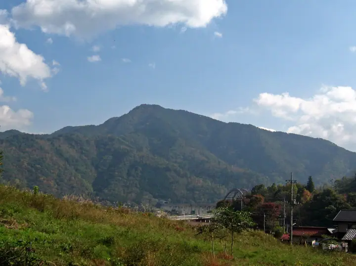
Mount Kuki hiking routes
Hiking times are estimates calculated from the terrain.
Huts, campsites and lodging near Mount Kuki
Lodging
- ビジネスホテル浜野屋
- Toyoko Inn Fujisan Otsuki-eki
Lists that include Mount Kuki
New 100 Famous Flower Mountains · Yamanashi 100 Famous Mountains · 12 Beautiful Views of Mount Fuji in Otsuki City (Yamanashi Prefecture) · 21 Outstanding Peaks of Tsuru City (Yamanashi Prefecture)
Mount Kuki facts
- Elevation
- 970 m
- Location
- Ōtsuki-shi, Yamanashi
35.576659, 138.951060 - Website
- www.city.tsuru.yamanashi.jp
- Trail Map
- www.city.tsuru.yamanashi.jp (PDF)
- Wikipedia
- ja.wikipedia.org