
Mt. Ōgi
扇山
Ōtsuki-shi, Yamanashi · Elevation 1,138 m
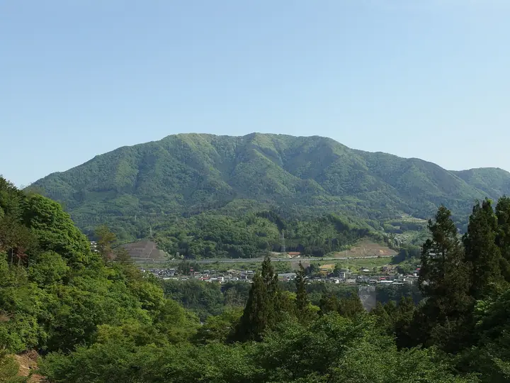
Mt. Ōgi (1,138 m) sits on the border of Ōtsuki and Uenohara in Yamanashi along the Chūō Main Line; its name ("Folding-Fan Mountain") comes from its silhouette spreading like an open fan. Listed as Peak No. 6 of Ōtsuki's "Twelve Splendid Fuji Views," it ranks—together with neighbouring Mt. Momokura—as one of the most popular peaks of that set. The broad summit gives a striking view of Mt. Fuji rising behind nearby Mt. Shakushi, with the Shinjuku skyline visible to the south-east on clear days. Trails climb from Torisawa, Shiotsu, and Yanagawa stations on the Chūō Main Line, and a traverse with Mt. Momokura is a classic outing. The peak is counted among the 100 Famous Mountains of Yamanashi, Japan's 100 Low Mountains, and the 100 Famous Mountains of Kantō.
Mt. Ōgi at a glance
- Weather: The most settled day in the next 7 days is Mon, November 9: cloudy, gusts up to 5 m/s.
- Route: The shortest is Mount Ogiyama–Mount Momokurayama Traverse: about 7 h 24 min, 14.4 km, about 1,220 m of climbing.
Mt. Ōgi weather (hourly, 14 days)
Sunrise today 06:07, sunset 16:48
| Tue, 11/3 | Wed, 11/4 | Thu, 11/5 | Fri, 11/6 | Sat, 11/7 | Sun, 11/8 | Mon, 11/9 | Tue, 11/10 | Wed, 11/11 | Thu, 11/12 | Fri, 11/13 | Sat, 11/14 | Sun, 11/15 | Mon, 11/16 | Tue, 11/17 | |||||||||||||||||||||||||||||||||||||||||||||||||||||||||||||||||||||||
|---|---|---|---|---|---|---|---|---|---|---|---|---|---|---|---|---|---|---|---|---|---|---|---|---|---|---|---|---|---|---|---|---|---|---|---|---|---|---|---|---|---|---|---|---|---|---|---|---|---|---|---|---|---|---|---|---|---|---|---|---|---|---|---|---|---|---|---|---|---|---|---|---|---|---|---|---|---|---|---|---|---|---|---|---|---|
| Japan time | 21 | 23 | 1 | 3 | 5 | 7 | 9 | 11 | 13 | 15 | 17 | 19 | 21 | 0 | 3 | 6 | 9 | 12 | 15 | 18 | 21 | 0 | 3 | 6 | 9 | 12 | 15 | 18 | 21 | 0 | 3 | 6 | 9 | 12 | 15 | 18 | 21 | 0 | 3 | 6 | 9 | 12 | 15 | 18 | 21 | 0 | 3 | 6 | 9 | 12 | 15 | 21 | 3 | 9 | 15 | 21 | 3 | 9 | 15 | 21 | 3 | 9 | 15 | 21 | 3 | 9 | 15 | 21 | 3 | 9 | 15 | 21 | 3 | 9 | 15 | 21 | 3 | 9 | 15 | 21 | 3 | 9 | 15 | 21 | |
  | |   | | |   | |   | | | | | | | | | |   |   |   | | | |  |  | | | | |   | | |   | | | | | | | | | | | | | | | | | | | | | | | | | | |   |  | | | |   | | | | | | | | | | | | |   | | | | | | | ||
| Temperature | °C | 7° | 6° | 6° | 6° | 5° | 4° | 6° | 6° | 6° | 5° | 5° | 5° | 5° | 6° | 6° | 6° | 9° | 13° | 11° | 8° | 6° | 5° | 6° | 5° | 14° | 18° | 16° | 9° | 7° | 5° | 3° | 3° | 10° | 12° | 9° | 3° | 1° | 1° | 1° | 1° | 7° | 8° | 7° | 5° | 2° | 2° | 2° | 2° | 2° | 4° | 4° | 3° | 1° | 2° | 6° | 2° | 1° | 5° | 9° | -2° | -3° | 5° | 6° | 3° | 0° | 8° | 10° | -1° | -1° | 3° | 6° | 0° | -1° | 8° | 11° | 6° | 6° | 11° | 15° | 4° | 3° | 2° | 4° | 1° |
| Precipitation | mm | 0.3 | 0.2 | 0.2 | 0.6 | 0.1 | 1.0 | 1.3 | 4.1 | 11 | 14 | 7 | 1.9 | 0.4 | 0.1 | 0.1 | 0.3 | 0.3 | 0.2 | 0.6 | 0.6 | 0.1 | 0.2 | 0.1 | 3.7 | 14 | 0.1 | 0.1 | |||||||||||||||||||||||||||||||||||||||||||||||||||||||||
| New snow | cm | ||||||||||||||||||||||||||||||||||||||||||||||||||||||||||||||||||||||||||||||||||||
| Snow depth | cm | 0 | 0 | 0 | 0 | 0 | 0 | 0 | 0 | 0 | 0 | 0 | 0 | 0 | 0 | 0 | 0 | 0 | 0 | 0 | 0 | 0 | 0 | 0 | 0 | 0 | 0 | 0 | 0 | 0 | 0 | 0 | 0 | 0 | 0 | 0 | 0 | 0 | 0 | 0 | 0 | 0 | 0 | 0 | 0 | 0 | 0 | 0 | 0 | 0 | 0 | 0 | 0 | 0 | 0 | 0 | 0 | 0 | 0 | 0 | 0 | 0 | 0 | 0 | 0 | 0 | 0 | 0 | 0 | 0 | 0 | 0 | 0 | 0 | 0 | 0 | 0 | 0 | 0 | 0 | 0 | 0 | 0 | 0 | 0 |
| Wind | m/s | 1 | 0 | 0 | 1 | 1 | 0 | 1 | 2 | 2 | 2 | 1 | 1 | 2 | 0 | 1 | 1 | 1 | 2 | 1 | 0 | 2 | 2 | 2 | 1 | 1 | 1 | 2 | 1 | 0 | 2 | 1 | 1 | 1 | 1 | 3 | 1 | 1 | 1 | 0 | 1 | 1 | 3 | 2 | 1 | 0 | 1 | 1 | 1 | 1 | 1 | 1 | 1 | 2 | 2 | 2 | 0 | 2 | 3 | 2 | 2 | 2 | 1 | 3 | 1 | 2 | 1 | 2 | 0 | 0 | 1 | 2 | 1 | 1 | 1 | 1 | 1 | 2 | 2 | 2 | 0 | 1 | 1 | 2 | 1 |
| Wind gusts | m/s | 2 | 2 | 2 | 2 | 4 | 3 | 4 | 6 | 5 | 5 | 5 | 4 | 3 | 3 | 4 | 4 | 4 | 5 | 5 | 3 | 5 | 6 | 7 | 8 | 5 | 6 | 7 | 6 | 2 | 4 | 5 | 4 | 6 | 7 | 8 | 8 | 4 | 4 | 3 | 2 | 4 | 7 | 8 | 5 | 2 | 3 | 3 | 3 | 4 | 5 | 5 | 6 | 5 | 5 | 7 | 6 | 5 | 9 | 10 | 6 | 5 | 4 | 7 | 7 | 5 | 6 | 7 | 8 | 2 | 4 | 6 | 5 | 4 | 6 | 7 | 5 | 6 | 7 | 8 | 7 | 4 | 5 | 6 | 6 |
| Wind dir. | ↓ | ↓ | ↓ | ↓ | ↓ | ↓ | ↓ | ↓ | ↓ | ↓ | ↓ | ↓ | ↓ | ↓ | ↓ | ↓ | ↓ | ↓ | ↓ | ↓ | ↓ | ↓ | ↓ | ↓ | ↓ | ↓ | ↓ | ↓ | ↓ | ↓ | ↓ | ↓ | ↓ | ↓ | ↓ | ↓ | ↓ | ↓ | ↓ | ↓ | ↓ | ↓ | ↓ | ↓ | ↓ | ↓ | ↓ | ↓ | ↓ | ↓ | ↓ | ↓ | ↓ | ↓ | ↓ | ↓ | ↓ | ↓ | ↓ | ↓ | ↓ | ↓ | ↓ | ↓ | ↓ | ↓ | ↓ | ↓ | ↓ | ↓ | ↓ | ↓ | ↓ | ↓ | ↓ | ↓ | ↓ | ↓ | ↓ | ↓ | ↓ | ↓ | ↓ | ↓ | |
Mt. Ōgi hiking routes
Hiking times are estimates calculated from the terrain.
Huts, campsites and lodging near Mt. Ōgi
Lodging
- 君恋温泉
Lists that include Mt. Ōgi
100 Low Mountains of Japan · Yamanashi 100 Famous Mountains · 12 Beautiful Views of Mount Fuji in Otsuki City (Yamanashi Prefecture) · Elevations of 1003 Mountains of Japan · 1000 Mountains of Japan
Mt. Ōgi facts
- Elevation
- 1,138 m
- Location
- Ōtsuki-shi, Yamanashi
35.637327, 139.013652 - Website
- www.yamanashi-kankou.jp
- Trail Map
- www.city.otsuki.yamanashi.jp (PDF)
- Wikipedia
- ja.wikipedia.org