
Mt. Shōtō
生藤山
Sagamihara, Kanagawa / Hinohara, Tokyo / Uenohara, Yamanashi · Elevation 990 m
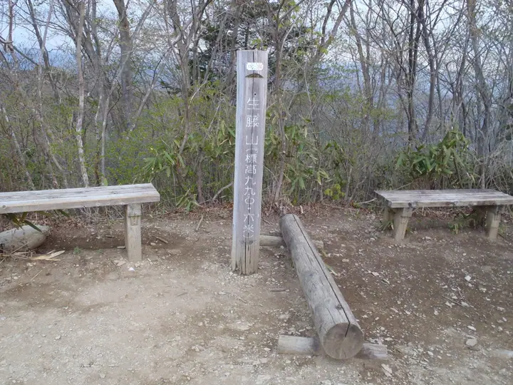
Mt. Shōtō (990 m) rises on the border of Hinohara Village in Tokyo and Sagamihara's Midori Ward in Kanagawa, on the Sasa-One ridge that links Mt. Jinba with the Okutama range, designated within the Tokyo Takao-Jinba and Kanagawa Jinba-Sagamiko Natural Parks. It forms the principal summit of a small chain with neighbouring Mt. Mikuni and Mt. Kayamaru, famed for its cherry promenade and the historic spring known as Kanzōsui just below the summit; Sumie Tanaka included it among her "100 Flower Mountains." Walkers reach it via traverses from Mt. Jinba on the Sasa-One ridge or from the Ido trailhead on the Uenohara side, and it is regarded as a sub-alpine highlight at the very northern tip of Kanagawa.
Mt. Shōtō at a glance
- Weather: The most settled day in the next 7 days is Wed, November 4: cloudy, gusts up to 5 m/s.
Mt. Shōtō weather (hourly, 14 days)
Sunrise today 06:07, sunset 16:48
| Tue, 11/3 | Wed, 11/4 | Thu, 11/5 | Fri, 11/6 | Sat, 11/7 | Sun, 11/8 | Mon, 11/9 | Tue, 11/10 | Wed, 11/11 | Thu, 11/12 | Fri, 11/13 | Sat, 11/14 | Sun, 11/15 | Mon, 11/16 | Tue, 11/17 | |||||||||||||||||||||||||||||||||||||||||||||||||||||||||||||||||||||||
|---|---|---|---|---|---|---|---|---|---|---|---|---|---|---|---|---|---|---|---|---|---|---|---|---|---|---|---|---|---|---|---|---|---|---|---|---|---|---|---|---|---|---|---|---|---|---|---|---|---|---|---|---|---|---|---|---|---|---|---|---|---|---|---|---|---|---|---|---|---|---|---|---|---|---|---|---|---|---|---|---|---|---|---|---|---|
| Japan time | 15 | 17 | 19 | 21 | 23 | 1 | 3 | 5 | 7 | 9 | 11 | 13 | 15 | 18 | 21 | 0 | 3 | 6 | 9 | 12 | 15 | 18 | 21 | 0 | 3 | 6 | 9 | 12 | 15 | 18 | 21 | 0 | 3 | 6 | 9 | 12 | 15 | 18 | 21 | 0 | 3 | 6 | 9 | 12 | 15 | 18 | 21 | 0 | 3 | 6 | 9 | 15 | 21 | 3 | 9 | 15 | 21 | 3 | 9 | 15 | 21 | 3 | 9 | 15 | 21 | 3 | 9 | 15 | 21 | 3 | 9 | 15 | 21 | 3 | 9 | 15 | 21 | 3 | 9 | 15 | 21 | 3 | 9 | 15 | |
  |   | | | |   | | | | | |   | | | | | | | |   |   |   |   | |   | |  | | | | | | | |   | | | |  | | | | | | | | | | | | | | | | | | | | | |   |  | | | | | | | | | | | | | | | | |   | | | | | | ||
| Temperature | °C | 11° | 10° | 9° | 8° | 8° | 7° | 7° | 7° | 6° | 7° | 8° | 8° | 7° | 7° | 7° | 7° | 7° | 7° | 10° | 15° | 12° | 10° | 8° | 8° | 7° | 6° | 14° | 18° | 16° | 11° | 9° | 8° | 7° | 5° | 10° | 12° | 10° | 6° | 4° | 4° | 3° | 2° | 8° | 10° | 9° | 7° | 6° | 5° | 5° | 4° | 5° | 7° | 5° | 3° | 5° | 7° | 4° | 2° | 7° | 10° | 0° | -2° | 6° | 7° | 5° | 1° | 9° | 10° | 1° | 0° | 4° | 7° | 1° | 0° | 8° | 11° | 8° | 7° | 13° | 16° | 6° | 4° | 3° | 6° |
| Precipitation | mm | 0.2 | 1.1 | 0.9 | 0.1 | 0.3 | 0.4 | 0.7 | 2.7 | 8 | 15 | 11 | 3.3 | 0.7 | 3.9 | 0.5 | 0.4 | 0.9 | 3.3 | 14 | 0.1 | 0.1 | |||||||||||||||||||||||||||||||||||||||||||||||||||||||||||||||
| New snow | cm | ||||||||||||||||||||||||||||||||||||||||||||||||||||||||||||||||||||||||||||||||||||
| Snow depth | cm | 0 | 0 | 0 | 0 | 0 | 0 | 0 | 0 | 0 | 0 | 0 | 0 | 0 | 0 | 0 | 0 | 0 | 0 | 0 | 0 | 0 | 0 | 0 | 0 | 0 | 0 | 0 | 0 | 0 | 0 | 0 | 0 | 0 | 0 | 0 | 0 | 0 | 0 | 0 | 0 | 0 | 0 | 0 | 0 | 0 | 0 | 0 | 0 | 0 | 0 | 0 | 0 | 0 | 0 | 0 | 0 | 0 | 0 | 0 | 0 | 0 | 0 | 0 | 0 | 0 | 0 | 0 | 0 | 0 | 0 | 0 | 0 | 0 | 0 | 0 | 0 | 0 | 0 | 0 | 0 | 0 | 0 | 0 | 0 |
| Wind | m/s | 2 | 0 | 0 | 0 | 0 | 0 | 0 | 0 | 1 | 1 | 1 | 1 | 0 | 1 | 1 | 0 | 2 | 1 | 1 | 2 | 2 | 1 | 1 | 1 | 2 | 2 | 0 | 2 | 2 | 1 | 1 | 1 | 1 | 1 | 1 | 3 | 3 | 1 | 1 | 1 | 0 | 1 | 2 | 3 | 2 | 0 | 1 | 1 | 0 | 1 | 1 | 2 | 1 | 1 | 1 | 2 | 1 | 2 | 3 | 2 | 2 | 2 | 1 | 2 | 1 | 3 | 1 | 3 | 1 | 1 | 1 | 2 | 1 | 1 | 1 | 2 | 1 | 1 | 1 | 3 | 0 | 2 | 1 | 2 |
| Wind gusts | m/s | 6 | 5 | 2 | 1 | 1 | 2 | 2 | 2 | 2 | 3 | 4 | 5 | 5 | 2 | 3 | 4 | 4 | 5 | 4 | 6 | 6 | 4 | 3 | 4 | 5 | 5 | 5 | 7 | 8 | 6 | 3 | 3 | 4 | 3 | 5 | 8 | 10 | 8 | 3 | 3 | 2 | 2 | 5 | 8 | 8 | 6 | 2 | 3 | 3 | 2 | 4 | 7 | 5 | 4 | 4 | 7 | 6 | 4 | 8 | 11 | 6 | 5 | 4 | 8 | 6 | 6 | 6 | 9 | 8 | 2 | 4 | 7 | 6 | 4 | 5 | 7 | 5 | 6 | 7 | 9 | 7 | 5 | 5 | 6 |
| Wind dir. | ↓ | ↓ | ↓ | ↓ | ↓ | ↓ | ↓ | ↓ | ↓ | ↓ | ↓ | ↓ | ↓ | ↓ | ↓ | ↓ | ↓ | ↓ | ↓ | ↓ | ↓ | ↓ | ↓ | ↓ | ↓ | ↓ | ↓ | ↓ | ↓ | ↓ | ↓ | ↓ | ↓ | ↓ | ↓ | ↓ | ↓ | ↓ | ↓ | ↓ | ↓ | ↓ | ↓ | ↓ | ↓ | ↓ | ↓ | ↓ | ↓ | ↓ | ↓ | ↓ | ↓ | ↓ | ↓ | ↓ | ↓ | ↓ | ↓ | ↓ | ↓ | ↓ | ↓ | ↓ | ↓ | ↓ | ↓ | ↓ | ↓ | ↓ | ↓ | ↓ | ↓ | ↓ | ↓ | ↓ | ↓ | ↓ | ↓ | ↓ | ↓ | ↓ | ↓ | ↓ | |
Huts, campsites and lodging near Mt. Shōtō
Campsites
- 桐花園キャンプ場
- キャンピングガーデン モク
Lodging
- 陣馬の湯陣渓園
- 陣馬の湯姫谷
Lists that include Mt. Shōtō
100 Famous Mountains of Flowers · Kanto 100 Famous Mountains · 100 Mountains of Tama · 15 Famous Mountains of Fujino (Kanagawa Prefecture) · 1000 Mountains of Japan
Mt. Shōtō facts
- Also known as
- キット山 · スズナリ
- Elevation
- 990 m
- Location
- Sagamihara, Kanagawa / Hinohara, Tokyo / Uenohara, Yamanashi
35.672419, 139.132394 - Website
- info-fujino.com
- Trail Map
- info-fujino.com (PDF)
- Wikipedia
- ja.wikipedia.org