
Mount Kichijō
吉祥山
Toyohashi, Aichi / Shinshiro, Aichi · Elevation 382 m
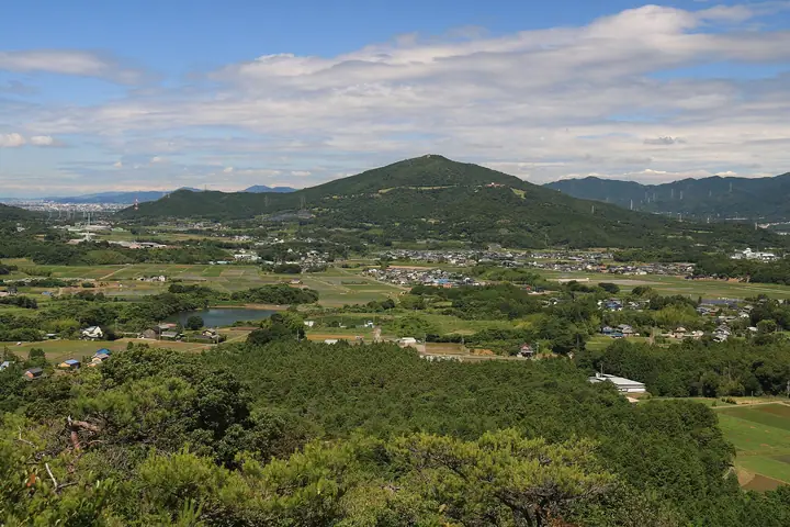
Mount Kichijō is a 382.5 m peak straddling Shinshiro City and Toyohashi City in Aichi Prefecture. About 20 ha of the summit area is designated as an Aichi Prefectural Natural Environment Conservation Area, and the north ridge supports a stand of large chinkapin oaks. The name comes from the Kichijōten goddess once enshrined here as the inner sanctuary of Imamizu-ji, an important Heian-era temple. The southern slopes on the Toyohashi side are maintained as the Kichijōsan Citizens' Friendship Forest with several courses (A, B, C and the Yokubari Viewpoint Course), and the summit offers views of Mikawa Bay, the Oku-Mikawa mountains, the Southern Japan Alps and, on clear days, Mount Fuji. The peak is listed in Aichi's 130 Mountains, the Bunken Tozan Guide for Aichi Prefecture, and the 110 Mountains around the Tōkai Region.
Mount Kichijō at a glance
- Weather: The most settled day in the next 7 days is Wed, November 4: cloudy, gusts up to 4 m/s. Fri, Nov 6, Sat, Nov 7: strong wind (gusts up to 17 m/s).
Mount Kichijō weather (hourly, 14 days)
Sunrise today 06:12, sunset 16:55
| Tue, 11/3 | Wed, 11/4 | Thu, 11/5 | Fri, 11/6 | Sat, 11/7 | Sun, 11/8 | Mon, 11/9 | Tue, 11/10 | Wed, 11/11 | Thu, 11/12 | Fri, 11/13 | Sat, 11/14 | Sun, 11/15 | Mon, 11/16 | Tue, 11/17 | |||||||||||||||||||||||||||||||||||||||||||||||||||||||||||||||||||||||
|---|---|---|---|---|---|---|---|---|---|---|---|---|---|---|---|---|---|---|---|---|---|---|---|---|---|---|---|---|---|---|---|---|---|---|---|---|---|---|---|---|---|---|---|---|---|---|---|---|---|---|---|---|---|---|---|---|---|---|---|---|---|---|---|---|---|---|---|---|---|---|---|---|---|---|---|---|---|---|---|---|---|---|---|---|---|
| Japan time | 15 | 17 | 19 | 21 | 23 | 1 | 3 | 5 | 7 | 9 | 11 | 13 | 15 | 18 | 21 | 0 | 3 | 6 | 9 | 12 | 15 | 18 | 21 | 0 | 3 | 6 | 9 | 12 | 15 | 18 | 21 | 0 | 3 | 6 | 9 | 12 | 15 | 18 | 21 | 0 | 3 | 6 | 9 | 12 | 15 | 18 | 21 | 0 | 3 | 6 | 9 | 15 | 21 | 3 | 9 | 15 | 21 | 3 | 9 | 15 | 21 | 3 | 9 | 15 | 21 | 3 | 9 | 15 | 21 | 3 | 9 | 15 | 21 | 3 | 9 | 15 | 21 | 3 | 9 | 15 | 21 | 3 | 9 | 15 | |
 |  |   | | | | | |   |   | | |   |   | | | |   | | |   |   | |   | |   | | | | |  | | | | | | | | | | | | | | | | | | | | | | | | | |   | | | | |  | | | | | | | | | | | | | | | | |   | |  | | | | ||
| Temperature | °C | 19° | 15° | 12° | 10° | 9° | 9° | 9° | 9° | 10° | 15° | 16° | 16° | 16° | 13° | 13° | 13° | 13° | 13° | 17° | 21° | 18° | 16° | 13° | 12° | 12° | 14° | 17° | 19° | 18° | 14° | 12° | 11° | 9° | 8° | 11° | 13° | 12° | 9° | 7° | 6° | 5° | 5° | 11° | 15° | 14° | 9° | 9° | 9° | 8° | 7° | 13° | 15° | 8° | 6° | 13° | 15° | 10° | 7° | 9° | 13° | 6° | 3° | 11° | 13° | 7° | 7° | 11° | 14° | 6° | 8° | 12° | 12° | 10° | 11° | 15° | 14° | 13° | 13° | 16° | 19° | 11° | 7° | 12° | 12° |
| Precipitation | mm | 0.4 | 1.0 | 2.7 | 6 | 4.0 | 0.4 | 0.4 | 0.1 | 3.9 | 19 | 25 | 3.9 | 0.7 | 1.1 | ||||||||||||||||||||||||||||||||||||||||||||||||||||||||||||||||||||||
| New snow | cm | ||||||||||||||||||||||||||||||||||||||||||||||||||||||||||||||||||||||||||||||||||||
| Snow depth | cm | 0 | 0 | 0 | 0 | 0 | 0 | 0 | 0 | 0 | 0 | 0 | 0 | 0 | 0 | 0 | 0 | 0 | 0 | 0 | 0 | 0 | 0 | 0 | 0 | 0 | 0 | 0 | 0 | 0 | 0 | 0 | 0 | 0 | 0 | 0 | 0 | 0 | 0 | 0 | 0 | 0 | 0 | 0 | 0 | 0 | 0 | 0 | 0 | 0 | 0 | 0 | 0 | 0 | 0 | 0 | 0 | 0 | 0 | 0 | 0 | 0 | 0 | 0 | 0 | 0 | 0 | 0 | 0 | 0 | 0 | 0 | 0 | 0 | 0 | 0 | 0 | 0 | 0 | 0 | 0 | 0 | 0 | 0 | 0 |
| Wind | m/s | 1 | 0 | 1 | 1 | 1 | 1 | 1 | 1 | 2 | 1 | 1 | 0 | 1 | 4 | 0 | 2 | 1 | 1 | 1 | 2 | 2 | 0 | 2 | 1 | 2 | 3 | 5 | 7 | 6 | 6 | 6 | 6 | 5 | 5 | 6 | 7 | 7 | 4 | 3 | 5 | 5 | 4 | 2 | 2 | 2 | 1 | 1 | 1 | 1 | 1 | 2 | 4 | 1 | 1 | 0 | 3 | 4 | 6 | 6 | 6 | 4 | 2 | 1 | 3 | 3 | 3 | 4 | 6 | 2 | 2 | 1 | 1 | 2 | 2 | 3 | 3 | 2 | 3 | 4 | 6 | 5 | 4 | 2 | 3 |
| Wind gusts | m/s | 6 | 4 | 3 | 3 | 4 | 3 | 3 | 3 | 3 | 4 | 4 | 3 | 3 | 9 | 10 | 9 | 6 | 4 | 4 | 5 | 7 | 4 | 3 | 4 | 4 | 8 | 12 | 16 | 16 | 15 | 16 | 14 | 15 | 15 | 13 | 16 | 17 | 15 | 10 | 11 | 12 | 12 | 10 | 6 | 6 | 5 | 3 | 3 | 3 | 3 | 5 | 10 | 10 | 3 | 3 | 7 | 9 | 16 | 15 | 17 | 15 | 10 | 4 | 8 | 7 | 8 | 10 | 13 | 13 | 5 | 4 | 5 | 4 | 4 | 7 | 9 | 8 | 9 | 9 | 14 | 16 | 14 | 8 | 8 |
| Wind dir. | ↓ | ↓ | ↓ | ↓ | ↓ | ↓ | ↓ | ↓ | ↓ | ↓ | ↓ | ↓ | ↓ | ↓ | ↓ | ↓ | ↓ | ↓ | ↓ | ↓ | ↓ | ↓ | ↓ | ↓ | ↓ | ↓ | ↓ | ↓ | ↓ | ↓ | ↓ | ↓ | ↓ | ↓ | ↓ | ↓ | ↓ | ↓ | ↓ | ↓ | ↓ | ↓ | ↓ | ↓ | ↓ | ↓ | ↓ | ↓ | ↓ | ↓ | ↓ | ↓ | ↓ | ↓ | ↓ | ↓ | ↓ | ↓ | ↓ | ↓ | ↓ | ↓ | ↓ | ↓ | ↓ | ↓ | ↓ | ↓ | ↓ | ↓ | ↓ | ↓ | ↓ | ↓ | ↓ | ↓ | ↓ | ↓ | ↓ | ↓ | ↓ | ↓ | ↓ | ↓ | |
Huts, campsites and lodging near Mount Kichijō
Lodging
- 割烹旅館さくら別館
- 新城観光ホテル
- 松月旅館
- 旅館三好屋
Lists that include Mount Kichijō
Mount Kichijō facts
- Elevation
- 382 m
- Location
- Toyohashi, Aichi / Shinshiro, Aichi
34.857746, 137.478350 - Website
- www.okuminavi.jp
- Trail Map
- www.okuminavi.jp (PDF)
- Access Information
- www.city.toyohashi.lg.jp
- Wikipedia
- ja.wikipedia.org