
Mount Ishimaki
石巻山
Toyohashi, Aichi · Elevation 358 m
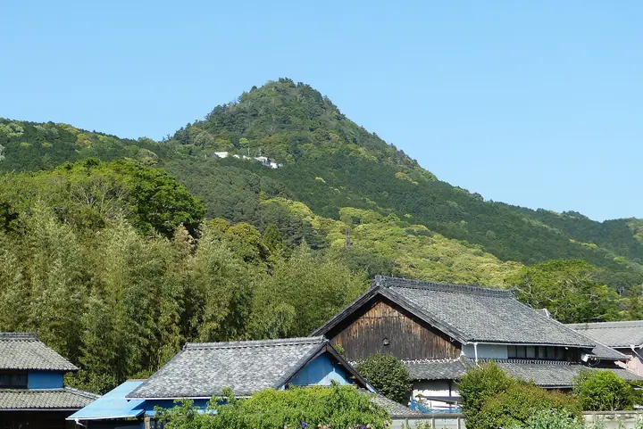
Mount Ishimaki (358 m) stands in the Ishimaki-chō district of Toyohashi City, Aichi Prefecture, at the southern end of the Yumihari mountain range along the Kosai ridge, and serves as one of the city's iconic landmarks. Its summit is crowned by a cluster of limestone outcrops that host a distinctive flora — including the Maruba-iwashimotsuke shrub and Kumonosu-shida fern — designated as a National Natural Monument under the name 'Ishimakisan Limestone Plant Community.' A mid-slope precinct holds Ishimaki Shrine and the Toyohashi Municipal Ishimaki Natural Science Museum, and during the Nanboku-chō period the slopes carried Ishimaki Castle. The peak is listed among Japan's Hundred Low Mountains and the Aichi 130 Mountains.
Mount Ishimaki at a glance
- Weather: The most settled day in the next 7 days is Wed, November 4: cloudy, gusts up to 5 m/s. Fri, Nov 6, Sat, Nov 7: strong wind (gusts up to 17 m/s).
- Route: The shortest is Toyohashi Limestone Top of Mount Ishimaki by the Upper Shrine to a 360-degree View: about 50 min, 1.4 km, about 160 m of climbing.
Mount Ishimaki weather (hourly, 14 days)
Sunrise today 06:12, sunset 16:56
| Tue, 11/3 | Wed, 11/4 | Thu, 11/5 | Fri, 11/6 | Sat, 11/7 | Sun, 11/8 | Mon, 11/9 | Tue, 11/10 | Wed, 11/11 | Thu, 11/12 | Fri, 11/13 | Sat, 11/14 | Sun, 11/15 | Mon, 11/16 | Tue, 11/17 | |||||||||||||||||||||||||||||||||||||||||||||||||||||||||||||||||||||||
|---|---|---|---|---|---|---|---|---|---|---|---|---|---|---|---|---|---|---|---|---|---|---|---|---|---|---|---|---|---|---|---|---|---|---|---|---|---|---|---|---|---|---|---|---|---|---|---|---|---|---|---|---|---|---|---|---|---|---|---|---|---|---|---|---|---|---|---|---|---|---|---|---|---|---|---|---|---|---|---|---|---|---|---|---|---|
| Japan time | 15 | 17 | 19 | 21 | 23 | 1 | 3 | 5 | 7 | 9 | 11 | 13 | 15 | 18 | 21 | 0 | 3 | 6 | 9 | 12 | 15 | 18 | 21 | 0 | 3 | 6 | 9 | 12 | 15 | 18 | 21 | 0 | 3 | 6 | 9 | 12 | 15 | 18 | 21 | 0 | 3 | 6 | 9 | 12 | 15 | 18 | 21 | 0 | 3 | 6 | 9 | 15 | 21 | 3 | 9 | 15 | 21 | 3 | 9 | 15 | 21 | 3 | 9 | 15 | 21 | 3 | 9 | 15 | 21 | 3 | 9 | 15 | 21 | 3 | 9 | 15 | 21 | 3 | 9 | 15 | 21 | 3 | 9 | 15 | |
  |  |   |   | | | | |   |   | |   | |   | | | |   | | |   | | | | |  |  | | | | | | | | | | | | | | | | | | | | | | | | | | | | | |   | | | | |  | | | | | | | |   | | | | | | | | |   | |  | | | | ||
| Temperature | °C | 19° | 16° | 14° | 12° | 11° | 11° | 10° | 10° | 12° | 15° | 16° | 16° | 16° | 14° | 14° | 14° | 13° | 14° | 17° | 21° | 18° | 17° | 15° | 14° | 13° | 15° | 17° | 20° | 19° | 15° | 13° | 12° | 11° | 10° | 12° | 14° | 13° | 10° | 8° | 7° | 7° | 7° | 11° | 15° | 15° | 11° | 10° | 10° | 9° | 8° | 13° | 16° | 10° | 7° | 13° | 15° | 11° | 9° | 10° | 14° | 8° | 5° | 11° | 14° | 9° | 8° | 11° | 15° | 8° | 9° | 12° | 13° | 11° | 12° | 15° | 15° | 15° | 14° | 16° | 19° | 12° | 8° | 12° | 14° |
| Precipitation | mm | 0.2 | 0.1 | 1.0 | 3.4 | 7 | 6 | 1.1 | 0.3 | 0.1 | 0.4 | 1.1 | 0.1 | 3.7 | 18 | 19 | 5 | 1.0 | 3.2 | ||||||||||||||||||||||||||||||||||||||||||||||||||||||||||||||||||
| New snow | cm | ||||||||||||||||||||||||||||||||||||||||||||||||||||||||||||||||||||||||||||||||||||
| Snow depth | cm | 0 | 0 | 0 | 0 | 0 | 0 | 0 | 0 | 0 | 0 | 0 | 0 | 0 | 0 | 0 | 0 | 0 | 0 | 0 | 0 | 0 | 0 | 0 | 0 | 0 | 0 | 0 | 0 | 0 | 0 | 0 | 0 | 0 | 0 | 0 | 0 | 0 | 0 | 0 | 0 | 0 | 0 | 0 | 0 | 0 | 0 | 0 | 0 | 0 | 0 | 0 | 0 | 0 | 0 | 0 | 0 | 0 | 0 | 0 | 0 | 0 | 0 | 0 | 0 | 0 | 0 | 0 | 0 | 0 | 0 | 0 | 0 | 0 | 0 | 0 | 0 | 0 | 0 | 0 | 0 | 0 | 0 | 0 | 0 |
| Wind | m/s | 1 | 1 | 1 | 1 | 2 | 1 | 1 | 1 | 1 | 1 | 1 | 1 | 2 | 5 | 2 | 4 | 1 | 2 | 0 | 2 | 1 | 1 | 2 | 1 | 1 | 3 | 6 | 7 | 7 | 6 | 6 | 6 | 6 | 5 | 6 | 7 | 7 | 5 | 4 | 6 | 6 | 5 | 3 | 2 | 2 | 1 | 1 | 1 | 1 | 2 | 3 | 5 | 1 | 1 | 0 | 2 | 4 | 7 | 6 | 7 | 5 | 3 | 2 | 3 | 3 | 3 | 4 | 6 | 3 | 1 | 2 | 2 | 3 | 2 | 3 | 2 | 1 | 1 | 4 | 7 | 5 | 5 | 2 | 3 |
| Wind gusts | m/s | 6 | 5 | 3 | 3 | 4 | 3 | 3 | 3 | 3 | 4 | 5 | 4 | 5 | 10 | 11 | 10 | 8 | 4 | 5 | 6 | 6 | 3 | 3 | 3 | 3 | 8 | 13 | 16 | 15 | 15 | 15 | 13 | 14 | 13 | 13 | 17 | 17 | 16 | 11 | 12 | 13 | 13 | 11 | 8 | 7 | 6 | 3 | 3 | 3 | 4 | 7 | 11 | 11 | 3 | 3 | 6 | 9 | 17 | 16 | 17 | 15 | 11 | 6 | 9 | 8 | 9 | 10 | 15 | 14 | 7 | 4 | 6 | 5 | 6 | 7 | 9 | 8 | 8 | 10 | 15 | 15 | 15 | 11 | 8 |
| Wind dir. | ↓ | ↓ | ↓ | ↓ | ↓ | ↓ | ↓ | ↓ | ↓ | ↓ | ↓ | ↓ | ↓ | ↓ | ↓ | ↓ | ↓ | ↓ | ↓ | ↓ | ↓ | ↓ | ↓ | ↓ | ↓ | ↓ | ↓ | ↓ | ↓ | ↓ | ↓ | ↓ | ↓ | ↓ | ↓ | ↓ | ↓ | ↓ | ↓ | ↓ | ↓ | ↓ | ↓ | ↓ | ↓ | ↓ | ↓ | ↓ | ↓ | ↓ | ↓ | ↓ | ↓ | ↓ | ↓ | ↓ | ↓ | ↓ | ↓ | ↓ | ↓ | ↓ | ↓ | ↓ | ↓ | ↓ | ↓ | ↓ | ↓ | ↓ | ↓ | ↓ | ↓ | ↓ | ↓ | ↓ | ↓ | ↓ | ↓ | ↓ | ↓ | ↓ | ↓ | ↓ | |
Mount Ishimaki hiking routes
Hiking times are estimates calculated from the terrain.
Lists that include Mount Ishimaki
100 Low Mountains of Japan · 130 Mountains of Aichi · 1000 Mountains of Japan
Mount Ishimaki facts
- Elevation
- 358 m
- Location
- Toyohashi, Aichi
34.789409, 137.459666 - Website
- www.city.toyohashi.lg.jp
- Trail Map
- www.city.toyohashi.lg.jp
- Wikipedia
- ja.wikipedia.org