
Mount Ishikari
石狩岳
Kamikawa, Hokkaido / Kamishihoro, Hokkaido · Elevation 1,967 m
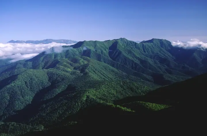
Mount Ishikari is a 1,967 m peak on the boundary between Kamishihoro and Kamikawa towns in central Hokkaido, the principal summit of the Higashi-Daisetsu range. Listed in the Nihon Nihyaku Meizan and the Hokkaidō Hyakumeizan, it lies within Daisetsuzan National Park and gives rise to the headwaters of the Ishikari River, Hokkaidō's largest. From the summit climbers can see the Tokachi range, the Hyō-Daisetsu, and the Higashi-Daisetsu spread out at once. The standard route enters along the Otofuke River forest road off National Route 273 and climbs the Schneider Course, one of the three steepest hiking trails in Hokkaidō, with sustained rocky pitches that make it suitable only for experienced hikers. The climbing season runs roughly from early June to mid-October, with the autumn foliage from mid-September through mid-October especially celebrated.
Mount Ishikari at a glance
- Weather: The most settled day in the next 7 days is Mon, November 9: cloudy, gusts up to 9 m/s. Wed, Nov 4, Sat, Nov 7, Sun, Nov 8: strong wind (gusts up to 32 m/s).
- Route: The shortest is East Daisetsu Mount Ishikari at the Source of the Ishikari River, Steep Ridge Return from the Nijuichi-no-sawa Trailhead: about 7 h 28 min, 11.0 km, about 1,230 m of climbing.
Mount Ishikari weather (hourly, 14 days)
Sunrise today 06:05, sunset 16:18
| Tue, 11/3 | Wed, 11/4 | Thu, 11/5 | Fri, 11/6 | Sat, 11/7 | Sun, 11/8 | Mon, 11/9 | Tue, 11/10 | Wed, 11/11 | Thu, 11/12 | Fri, 11/13 | Sat, 11/14 | Sun, 11/15 | Mon, 11/16 | Tue, 11/17 | |||||||||||||||||||||||||||||||||||||||||||||||||||||||||||||||||||||||
|---|---|---|---|---|---|---|---|---|---|---|---|---|---|---|---|---|---|---|---|---|---|---|---|---|---|---|---|---|---|---|---|---|---|---|---|---|---|---|---|---|---|---|---|---|---|---|---|---|---|---|---|---|---|---|---|---|---|---|---|---|---|---|---|---|---|---|---|---|---|---|---|---|---|---|---|---|---|---|---|---|---|---|---|---|---|
| Japan time | 15 | 17 | 19 | 21 | 23 | 1 | 3 | 5 | 7 | 9 | 11 | 13 | 15 | 18 | 21 | 0 | 3 | 6 | 9 | 12 | 15 | 18 | 21 | 0 | 3 | 6 | 9 | 12 | 15 | 18 | 21 | 0 | 3 | 6 | 9 | 12 | 15 | 18 | 21 | 0 | 3 | 6 | 9 | 12 | 15 | 18 | 21 | 0 | 3 | 6 | 9 | 15 | 21 | 3 | 9 | 15 | 21 | 3 | 9 | 15 | 21 | 3 | 9 | 15 | 21 | 3 | 9 | 15 | 21 | 3 | 9 | 15 | 21 | 3 | 9 | 15 | 21 | 3 | 9 | 15 | 21 | 3 | 9 | 15 | |
  |   |   |   | | | | | | | |   |  |  | | |   | | | |   | | |   | | |   | |   | |   | | | | | | | | | | | | | | | | | | | | |   |   | | | | | | | | | |   | | | | | | |  | | | | | | | | |   | | | |   | | ||
| Temperature | °C | -8° | -10° | -10° | -11° | -10° | -10° | -9° | -8° | -8° | -8° | -7° | -7° | -6° | -12° | -13° | -13° | -11° | -10° | -2° | 1° | 0° | -3° | -2° | -2° | -2° | -2° | -1° | -1° | 0° | -2° | -6° | -9° | -12° | -13° | -12° | -12° | -13° | -13° | -13° | -13° | -13° | -13° | -11° | -11° | -11° | -12° | -12° | -12° | -14° | -14° | -12° | -11° | -17° | -16° | -11° | -8° | -14° | -13° | -10° | -7° | -19° | -19° | -9° | -8° | -13° | -13° | -13° | -12° | -13° | -21° | -9° | -5° | -15° | -13° | -3° | -3° | -3° | -4° | -2° | -6° | -10° | -12° | -10° | -7° |
| Precipitation | mm | 0.2 | 0.2 | 0.2 | 1.7 | 0.6 | 0.6 | 0.5 | 0.2 | 0.7 | 1.7 | 2.7 | 5 | 2.0 | 0.4 | 0.8 | 0.5 | 0.7 | 0.2 | 0.2 | 0.7 | 1.5 | 1.1 | 0.4 | 0.4 | 0.6 | 1.2 | 1.3 | 2.7 | 2.7 | 2.3 | 1.0 | 0.2 | 0.1 | 0.1 | 0.1 | 0.9 | 1.8 | 0.6 | 0.2 | 0.1 | 0.8 | 0.8 | 0.7 | 0.1 | 0.3 | 1.7 | 2.3 | 0.9 | 2.6 | 0.5 | 0.4 | 0.1 | ||||||||||||||||||||||||||||||||
| New snow | cm | 0.2 | 0.2 | <.1 | 0.2 | 1.8 | 0.6 | 0.6 | 0.5 | 0.2 | <.1 | <.1 | <.1 | 0.7 | 0.2 | 0.2 | 0.6 | 1.5 | 1.1 | 0.4 | 0.4 | 0.6 | 1.2 | 1.3 | 2.7 | 2.7 | 2.2 | 1.0 | 0.2 | <.1 | <.1 | <.1 | 0.1 | 0.1 | 0.1 | <.1 | 0.9 | 1.8 | <.1 | 0.6 | 0.1 | 0.1 | 0.8 | 0.8 | 0.7 | <.1 | 0.1 | 2.2 | 0.5 | 0.4 | 0.1 | ||||||||||||||||||||||||||||||||||
| Snow depth | cm | 7 | 7 | 7 | 7 | 7 | 7 | 9 | 9 | 9 | 10 | 10 | 10 | 9 | 9 | 9 | 9 | 9 | 9 | 9 | 8 | 7 | 7 | 7 | 7 | 7 | 6 | 6 | 5 | 3 | 3 | 4 | 4 | 4 | 4 | 5 | 6 | 7 | 7 | 7 | 8 | 9 | 10 | 11 | 13 | 15 | 15 | 15 | 15 | 15 | 14 | 14 | 14 | 14 | 13 | 13 | 13 | 13 | 14 | 16 | 15 | 15 | 15 | 15 | 15 | 15 | 14 | 15 | 16 | 16 | 16 | 16 | 15 | 15 | 15 | 15 | 13 | 12 | 12 | 12 | 13 | 13 | 13 | 13 | 13 |
| Wind | m/s | 3 | 2 | 2 | 2 | 2 | 2 | 3 | 3 | 4 | 4 | 4 | 3 | 1 | 2 | 2 | 2 | 2 | 2 | 2 | 3 | 2 | 1 | 1 | 1 | 0 | 1 | 1 | 2 | 4 | 4 | 4 | 5 | 6 | 5 | 6 | 7 | 10 | 8 | 6 | 6 | 8 | 7 | 7 | 5 | 4 | 5 | 5 | 4 | 2 | 1 | 2 | 2 | 2 | 1 | 1 | 0 | 0 | 0 | 0 | 1 | 1 | 1 | 1 | 2 | 1 | 1 | 2 | 3 | 3 | 2 | 1 | 0 | 1 | 1 | 2 | 2 | 2 | 2 | 0 | 2 | 1 | 0 | 2 | 1 |
| Wind gusts | m/s | 14 | 11 | 11 | 11 | 11 | 11 | 12 | 14 | 19 | 17 | 16 | 16 | 14 | 9 | 10 | 11 | 11 | 11 | 10 | 12 | 12 | 8 | 6 | 5 | 4 | 5 | 7 | 10 | 14 | 17 | 18 | 21 | 23 | 23 | 19 | 24 | 32 | 33 | 29 | 25 | 26 | 27 | 25 | 25 | 19 | 20 | 20 | 19 | 14 | 9 | 7 | 9 | 8 | 7 | 6 | 5 | 4 | 3 | 4 | 6 | 5 | 6 | 6 | 9 | 9 | 7 | 9 | 17 | 18 | 15 | 9 | 6 | 6 | 7 | 10 | 12 | 11 | 11 | 10 | 7 | 9 | 7 | 7 | 6 |
| Wind dir. | ↓ | ↓ | ↓ | ↓ | ↓ | ↓ | ↓ | ↓ | ↓ | ↓ | ↓ | ↓ | ↓ | ↓ | ↓ | ↓ | ↓ | ↓ | ↓ | ↓ | ↓ | ↓ | ↓ | ↓ | ↓ | ↓ | ↓ | ↓ | ↓ | ↓ | ↓ | ↓ | ↓ | ↓ | ↓ | ↓ | ↓ | ↓ | ↓ | ↓ | ↓ | ↓ | ↓ | ↓ | ↓ | ↓ | ↓ | ↓ | ↓ | ↓ | ↓ | ↓ | ↓ | ↓ | ↓ | ↓ | ↓ | ↓ | ↓ | ↓ | ↓ | ↓ | ↓ | ↓ | ↓ | ↓ | ↓ | ↓ | ↓ | ↓ | ↓ | ↓ | ↓ | ↓ | ↓ | ↓ | ↓ | ↓ | ↓ | ↓ | ↓ | ↓ | ↓ | ↓ | |
Mount Ishikari hiking routes
Hiking times are estimates calculated from the terrain.
Lists that include Mount Ishikari
Japan 200 Famous Mountains · Japan's 300 Famous Mountains · Hokkaido 100 Famous Mountains · Elevations of 1003 Mountains of Japan · 1000 Mountains of Japan
Mount Ishikari facts
- Also known as
- 石狩岳最高点
- Elevation
- 1,967 m
- Location
- Kamikawa, Hokkaido / Kamishihoro, Hokkaido
43.546557, 143.022305 - National Park
- 大雪山国立公園
- Website
- www.daisetsuzan.or.jp
- Access Information
- hokkaido.env.go.jp
- Wikipedia
- en.wikipedia.org