
Mount Haruna
榛名山・掃部ヶ岳
Higashiagatsuma, Gunma / Takasaki, Gunma · Elevation 1,449 m
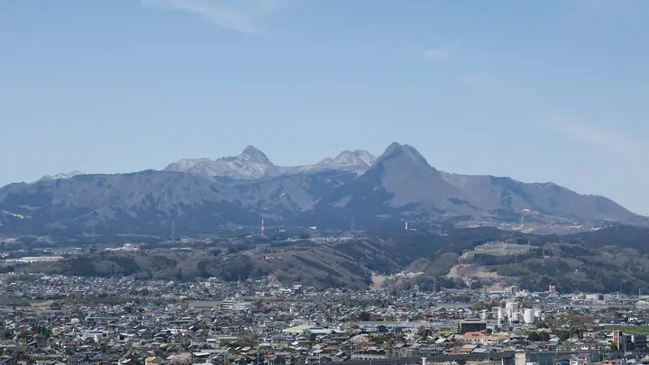
Mount Haruna is a stratovolcano spanning Takasaki and Higashiagatsuma in Gunma Prefecture. Its highest peak is Kamongatake (1449 m) on the outer rim. It contains Lake Haruna, surrounded by the outer rim and the central cone of Haruna Fuji. A focus of religious belief since antiquity, the mountain is home to Haruna Shrine. A ropeway reaches the summit of Haruna Fuji.
Mount Haruna at a glance
- Weather: The most settled day in the next 7 days is Mon, November 9: clear, gusts up to 7 m/s.
- Route: The shortest is Mount Kamongatake Out-and-Back from Lake Haruna: about 2 h 7 min, 3.2 km, about 370 m of climbing.
Mount Haruna weather (hourly, 14 days)
Sunrise today 06:09, sunset 16:47
| Tue, 11/3 | Wed, 11/4 | Thu, 11/5 | Fri, 11/6 | Sat, 11/7 | Sun, 11/8 | Mon, 11/9 | Tue, 11/10 | Wed, 11/11 | Thu, 11/12 | Fri, 11/13 | Sat, 11/14 | Sun, 11/15 | Mon, 11/16 | Tue, 11/17 | |||||||||||||||||||||||||||||||||||||||||||||||||||||||||||||||||||||||
|---|---|---|---|---|---|---|---|---|---|---|---|---|---|---|---|---|---|---|---|---|---|---|---|---|---|---|---|---|---|---|---|---|---|---|---|---|---|---|---|---|---|---|---|---|---|---|---|---|---|---|---|---|---|---|---|---|---|---|---|---|---|---|---|---|---|---|---|---|---|---|---|---|---|---|---|---|---|---|---|---|---|---|---|---|---|
| Japan time | 21 | 23 | 1 | 3 | 5 | 7 | 9 | 11 | 13 | 15 | 17 | 19 | 21 | 0 | 3 | 6 | 9 | 12 | 15 | 18 | 21 | 0 | 3 | 6 | 9 | 12 | 15 | 18 | 21 | 0 | 3 | 6 | 9 | 12 | 15 | 18 | 21 | 0 | 3 | 6 | 9 | 12 | 15 | 18 | 21 | 0 | 3 | 6 | 9 | 12 | 15 | 21 | 3 | 9 | 15 | 21 | 3 | 9 | 15 | 21 | 3 | 9 | 15 | 21 | 3 | 9 | 15 | 21 | 3 | 9 | 15 | 21 | 3 | 9 | 15 | 21 | 3 | 9 | 15 | 21 | 3 | 9 | 15 | 21 | |
  | | | | |   | | |  | |   | |   | | |   |   |   | | | | | |   | | | | |  | |   | | | | | | | | | | | | | | | | | | | | | | |   | | | | | | | | |   | | | | | |  | | | | | | | | | | | | | | | | ||
| Temperature | °C | 2° | 1° | 1° | 0° | 0° | 1° | 8° | 9° | 9° | 8° | 5° | 4° | 4° | 4° | 5° | 5° | 7° | 12° | 12° | 9° | 9° | 7° | 6° | 5° | 11° | 17° | 16° | 7° | 6° | 5° | 5° | 4° | 7° | 10° | 8° | 2° | 1° | 0° | 0° | -1° | 4° | 7° | 5° | 1° | 1° | 0° | 1° | 1° | 3° | 6° | 4° | 3° | 2° | 2° | 4° | 2° | 0° | 3° | 5° | 1° | -1° | 4° | 6° | 1° | -2° | 5° | 5° | -3° | -3° | 2° | 4° | -2° | -2° | 4° | 7° | 4° | 3° | 10° | 11° | 3° | -1° | 2° | 4° | -1° |
| Precipitation | mm | 0.2 | 4.4 | 9 | 7 | 1.7 | 0.2 | 0.1 | 1.4 | 1.4 | 0.2 | 3.2 | 0.7 | 0.6 | 3.7 | 7 | |||||||||||||||||||||||||||||||||||||||||||||||||||||||||||||||||||||
| New snow | cm | ||||||||||||||||||||||||||||||||||||||||||||||||||||||||||||||||||||||||||||||||||||
| Snow depth | cm | 0 | 0 | 0 | 0 | 0 | 0 | 0 | 0 | 0 | 0 | 0 | 0 | 0 | 0 | 0 | 0 | 0 | 0 | 0 | 0 | 0 | 0 | 0 | 0 | 0 | 0 | 0 | 0 | 0 | 0 | 0 | 0 | 0 | 0 | 0 | 0 | 0 | 0 | 0 | 0 | 0 | 0 | 0 | 0 | 0 | 0 | 0 | 0 | 0 | 0 | 0 | 0 | 0 | 0 | 0 | 0 | 0 | 0 | 0 | 0 | 0 | 0 | 0 | 0 | 0 | 0 | 0 | 0 | 0 | 0 | 0 | 0 | 0 | 0 | 0 | 0 | 0 | 0 | 0 | 0 | 0 | 0 | 0 | 0 |
| Wind | m/s | 1 | 2 | 2 | 2 | 2 | 2 | 1 | 3 | 3 | 3 | 1 | 0 | 1 | 2 | 1 | 1 | 1 | 1 | 1 | 0 | 0 | 1 | 2 | 2 | 2 | 1 | 1 | 2 | 3 | 3 | 3 | 3 | 1 | 3 | 3 | 2 | 1 | 3 | 3 | 2 | 3 | 3 | 3 | 1 | 2 | 1 | 1 | 1 | 1 | 2 | 1 | 0 | 2 | 2 | 2 | 2 | 2 | 4 | 4 | 0 | 2 | 1 | 1 | 1 | 2 | 2 | 4 | 1 | 2 | 1 | 2 | 1 | 1 | 1 | 1 | 1 | 2 | 2 | 5 | 3 | 2 | 1 | 2 | 0 |
| Wind gusts | m/s | 4 | 5 | 5 | 5 | 6 | 5 | 5 | 8 | 8 | 8 | 8 | 5 | 4 | 4 | 4 | 4 | 4 | 6 | 6 | 4 | 3 | 5 | 7 | 8 | 8 | 8 | 8 | 8 | 9 | 10 | 11 | 11 | 9 | 12 | 11 | 10 | 8 | 9 | 10 | 10 | 8 | 10 | 11 | 10 | 4 | 4 | 4 | 4 | 4 | 7 | 7 | 6 | 5 | 7 | 9 | 7 | 10 | 19 | 17 | 13 | 5 | 6 | 7 | 5 | 7 | 9 | 14 | 11 | 8 | 8 | 6 | 5 | 5 | 5 | 6 | 4 | 6 | 7 | 18 | 18 | 10 | 8 | 7 | 6 |
| Wind dir. | ↓ | ↓ | ↓ | ↓ | ↓ | ↓ | ↓ | ↓ | ↓ | ↓ | ↓ | ↓ | ↓ | ↓ | ↓ | ↓ | ↓ | ↓ | ↓ | ↓ | ↓ | ↓ | ↓ | ↓ | ↓ | ↓ | ↓ | ↓ | ↓ | ↓ | ↓ | ↓ | ↓ | ↓ | ↓ | ↓ | ↓ | ↓ | ↓ | ↓ | ↓ | ↓ | ↓ | ↓ | ↓ | ↓ | ↓ | ↓ | ↓ | ↓ | ↓ | ↓ | ↓ | ↓ | ↓ | ↓ | ↓ | ↓ | ↓ | ↓ | ↓ | ↓ | ↓ | ↓ | ↓ | ↓ | ↓ | ↓ | ↓ | ↓ | ↓ | ↓ | ↓ | ↓ | ↓ | ↓ | ↓ | ↓ | ↓ | ↓ | ↓ | ↓ | ↓ | ↓ | |
Mount Haruna hiking routes
Hiking times are estimates calculated from the terrain.
Huts, campsites and lodging near Mount Haruna
Campsites
- 榛名湖畔 まゆみヶ丘バンガロー
- 榛名湖オートキャンプ場
Lodging
- 湖楽亭
- つるや旅館
- 榛名湖アーティストレジデンス
- La saison de Haruna
- 榛名湖温泉 ゆうすげ
Lists that include Mount Haruna
Japan 200 Famous Mountains · Japan's 300 Famous Mountains · New 100 Famous Flower Mountains · 100 Low Mountains of Japan · Illustrated Collection of Japan's Famous Mountains · Kanto 100 Famous Mountains · Gunma 100 Famous Mountains · 3 Mountains of Jomo · Elevations of 1003 Mountains of Japan · 1000 Mountains of Japan
Mount Haruna facts
- Also known as
- 掃部ヶ岳 · Harunasan
- Elevation
- 1,449 m
- Location
- Higashiagatsuma, Gunma / Takasaki, Gunma
36.477413, 138.850880 - Volcano
- Active volcano (榛名山)
- Website
- www.city.takasaki.gunma.jp
- Trail Map
- harunavi.jp (PDF)
- Wikipedia
- ja.wikipedia.org