
Mount Furontō
風呂塔
Higashimiyoshi, Tokushima / Miyoshi, Tokushima · Elevation 1,401 m
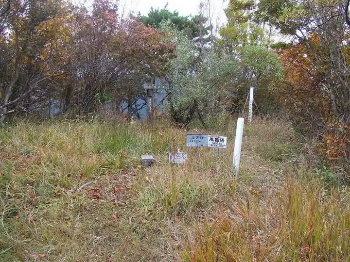
Mount Furontō (1,401 m) straddles East Miyoshi Town and Miyoshi City in the Iya range of Tokushima Prefecture and is the highest peak in East Miyoshi Town. The unusual name is said to come from the furnace ("furo") and copper slag piled like a tower from former copper smelting on the slope, and town records preserve the legend of five-element deities (Mizu-mine, Ne-mine, Kin-mine, Shiro-mine, Hi-mine) once enshrined around the summit. The summit is reached in roughly thirty minutes on a footpath from the closed Furontō campground, accessed via a forest road from Sajiki Pass on Tokushima Route 44.
Mount Furontō at a glance
- Weather: The most settled day in the next 7 days is Sun, November 8: clear, gusts up to 7 m/s.
Mount Furontō weather (hourly, 14 days)
Sunrise today 06:25, sunset 17:11
| Tue, 11/3 | Wed, 11/4 | Thu, 11/5 | Fri, 11/6 | Sat, 11/7 | Sun, 11/8 | Mon, 11/9 | Tue, 11/10 | Wed, 11/11 | Thu, 11/12 | Fri, 11/13 | Sat, 11/14 | Sun, 11/15 | Mon, 11/16 | Tue, 11/17 | |||||||||||||||||||||||||||||||||||||||||||||||||||||||||||||||||||||||
|---|---|---|---|---|---|---|---|---|---|---|---|---|---|---|---|---|---|---|---|---|---|---|---|---|---|---|---|---|---|---|---|---|---|---|---|---|---|---|---|---|---|---|---|---|---|---|---|---|---|---|---|---|---|---|---|---|---|---|---|---|---|---|---|---|---|---|---|---|---|---|---|---|---|---|---|---|---|---|---|---|---|---|---|---|---|
| Japan time | 15 | 17 | 19 | 21 | 23 | 1 | 3 | 5 | 7 | 9 | 11 | 13 | 15 | 18 | 21 | 0 | 3 | 6 | 9 | 12 | 15 | 18 | 21 | 0 | 3 | 6 | 9 | 12 | 15 | 18 | 21 | 0 | 3 | 6 | 9 | 12 | 15 | 18 | 21 | 0 | 3 | 6 | 9 | 12 | 15 | 18 | 21 | 0 | 3 | 6 | 9 | 15 | 21 | 3 | 9 | 15 | 21 | 3 | 9 | 15 | 21 | 3 | 9 | 15 | 21 | 3 | 9 | 15 | 21 | 3 | 9 | 15 | 21 | 3 | 9 | 15 | 21 | 3 | 9 | 15 | 21 | 3 | 9 | 15 | |
 |   |   |   | | | | |   |   | | | | | |   | | |   | |   | | |   | | | | | |  | | | | | | | | | | | | | | | | | | | | | | | | | |   |   | | | | | | | | | | | | | | | | | | | | | | | | |   | | | ||
| Temperature | °C | 11° | 9° | 7° | 7° | 6° | 7° | 7° | 7° | 7° | 8° | 11° | 11° | 11° | 9° | 10° | 9° | 10° | 9° | 12° | 16° | 16° | 12° | 13° | 13° | 11° | 9° | 9° | 12° | 11° | 8° | 5° | 4° | 3° | 2° | 4° | 6° | 7° | 3° | 2° | 1° | 0° | -1° | 6° | 9° | 8° | 4° | 5° | 3° | 4° | 5° | 8° | 10° | 5° | 3° | 6° | 8° | 3° | 1° | 2° | 6° | 2° | -2° | 5° | 8° | 3° | 2° | 5° | 7° | 1° | -1° | 7° | 11° | 3° | 3° | 12° | 12° | 11° | 10° | 10° | 10° | 6° | 2° | 4° | 8° |
| Precipitation | mm | 0.9 | 1.3 | 1.3 | 0.8 | 0.1 | 2.0 | 1.1 | 0.5 | 0.3 | 1.2 | 0.6 | 0.2 | 0.3 | 0.1 | 0.7 | 0.1 | 1.9 | 2.1 | 3.5 | 3.0 | 0.5 | |||||||||||||||||||||||||||||||||||||||||||||||||||||||||||||||
| New snow | cm | ||||||||||||||||||||||||||||||||||||||||||||||||||||||||||||||||||||||||||||||||||||
| Snow depth | cm | 0 | 0 | 0 | 0 | 0 | 0 | 0 | 0 | 0 | 0 | 0 | 0 | 0 | 0 | 0 | 0 | 0 | 0 | 0 | 0 | 0 | 0 | 0 | 0 | 0 | 0 | 0 | 0 | 0 | 0 | 0 | 0 | 0 | 0 | 0 | 0 | 0 | 0 | 0 | 0 | 0 | 0 | 0 | 0 | 0 | 0 | 0 | 0 | 0 | 0 | 0 | 0 | 0 | 0 | 0 | 0 | 0 | 0 | 0 | 0 | 0 | 0 | 0 | 0 | 0 | 0 | 0 | 0 | 0 | 0 | 0 | 0 | 0 | 0 | 0 | 0 | 0 | 0 | 0 | 0 | 0 | 0 | 0 | 0 |
| Wind | m/s | 2 | 0 | 0 | 1 | 1 | 2 | 2 | 3 | 3 | 3 | 3 | 2 | 1 | 1 | 0 | 2 | 0 | 0 | 0 | 0 | 1 | 2 | 3 | 3 | 4 | 3 | 3 | 5 | 5 | 4 | 4 | 4 | 4 | 3 | 4 | 4 | 3 | 1 | 1 | 0 | 0 | 1 | 1 | 2 | 2 | 0 | 1 | 1 | 1 | 1 | 2 | 3 | 1 | 1 | 2 | 4 | 3 | 4 | 3 | 4 | 1 | 1 | 1 | 2 | 1 | 1 | 3 | 3 | 1 | 1 | 1 | 1 | 2 | 2 | 2 | 4 | 3 | 1 | 3 | 4 | 3 | 1 | 1 | 2 |
| Wind gusts | m/s | 8 | 6 | 3 | 4 | 4 | 5 | 7 | 7 | 9 | 9 | 9 | 8 | 6 | 5 | 4 | 7 | 7 | 3 | 3 | 4 | 7 | 7 | 10 | 12 | 13 | 13 | 12 | 14 | 15 | 15 | 14 | 13 | 13 | 13 | 14 | 14 | 12 | 11 | 6 | 5 | 3 | 3 | 5 | 7 | 7 | 7 | 3 | 4 | 5 | 4 | 7 | 10 | 8 | 5 | 7 | 12 | 11 | 13 | 13 | 13 | 12 | 4 | 5 | 8 | 8 | 7 | 8 | 11 | 10 | 4 | 5 | 6 | 6 | 7 | 9 | 13 | 15 | 13 | 10 | 14 | 12 | 8 | 4 | 8 |
| Wind dir. | ↓ | ↓ | ↓ | ↓ | ↓ | ↓ | ↓ | ↓ | ↓ | ↓ | ↓ | ↓ | ↓ | ↓ | ↓ | ↓ | ↓ | ↓ | ↓ | ↓ | ↓ | ↓ | ↓ | ↓ | ↓ | ↓ | ↓ | ↓ | ↓ | ↓ | ↓ | ↓ | ↓ | ↓ | ↓ | ↓ | ↓ | ↓ | ↓ | ↓ | ↓ | ↓ | ↓ | ↓ | ↓ | ↓ | ↓ | ↓ | ↓ | ↓ | ↓ | ↓ | ↓ | ↓ | ↓ | ↓ | ↓ | ↓ | ↓ | ↓ | ↓ | ↓ | ↓ | ↓ | ↓ | ↓ | ↓ | ↓ | ↓ | ↓ | ↓ | ↓ | ↓ | ↓ | ↓ | ↓ | ↓ | ↓ | ↓ | ↓ | ↓ | ↓ | ↓ | ||
Huts, campsites and lodging near Mount Furontō
Mountain huts
- 落合峠避難小屋
Mount Furontō facts
- Also known as
- 風呂の塔
- Elevation
- 1,401 m
- Location
- Higashimiyoshi, Tokushima / Miyoshi, Tokushima
33.963922, 133.954470 - Website
- www.town.higashimiyoshi.lg.jp
- Wikipedia
- ja.wikipedia.org