
Mt. Tsukiore
月居山
Daigo, Ibaraki · Elevation 404 m
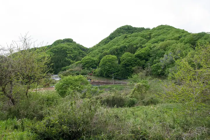
Mt. Tsukiore is a 404 m peak in Daigo Town, Kuji District, Ibaraki Prefecture, rising just south of Fukuroda Falls — one of Japan's three most celebrated waterfalls. The summit holds the ruins of the medieval Tsukiore Castle, and at the northern foot stands Tsukiore Kannon-dō, sheltering a Shō-Kannon statue attributed to the sculptor Unkei. The popular half-day circuit climbs from the Fukuroda Falls suspension bridge up the 'Seven Bends' trail to the summit, taking in the castle ruins and Kannon hall before descending back to the falls. The area lies within Okukuji Prefectural Natural Park and is a noted autumn-foliage spot. The mountain features in 'Mountains of Ibaraki' (the prefectural climbing guide), 'Mountains of the Tokyo Area' and several other Kantō-area selections.
Mt. Tsukiore at a glance
- Weather: The most settled day in the next 7 days is Mon, November 9: clear, gusts up to 8 m/s. Sat, Nov 7: strong wind (gusts up to 16 m/s).
Mt. Tsukiore weather (hourly, 14 days)
Sunrise today 06:03, sunset 16:41
| Tue, 11/3 | Wed, 11/4 | Thu, 11/5 | Fri, 11/6 | Sat, 11/7 | Sun, 11/8 | Mon, 11/9 | Tue, 11/10 | Wed, 11/11 | Thu, 11/12 | Fri, 11/13 | Sat, 11/14 | Sun, 11/15 | Mon, 11/16 | Tue, 11/17 | |||||||||||||||||||||||||||||||||||||||||||||||||||||||||||||||||||||||
|---|---|---|---|---|---|---|---|---|---|---|---|---|---|---|---|---|---|---|---|---|---|---|---|---|---|---|---|---|---|---|---|---|---|---|---|---|---|---|---|---|---|---|---|---|---|---|---|---|---|---|---|---|---|---|---|---|---|---|---|---|---|---|---|---|---|---|---|---|---|---|---|---|---|---|---|---|---|---|---|---|---|---|---|---|---|
| Japan time | 15 | 17 | 19 | 21 | 23 | 1 | 3 | 5 | 7 | 9 | 11 | 13 | 15 | 18 | 21 | 0 | 3 | 6 | 9 | 12 | 15 | 18 | 21 | 0 | 3 | 6 | 9 | 12 | 15 | 18 | 21 | 0 | 3 | 6 | 9 | 12 | 15 | 18 | 21 | 0 | 3 | 6 | 9 | 12 | 15 | 18 | 21 | 0 | 3 | 6 | 9 | 15 | 21 | 3 | 9 | 15 | 21 | 3 | 9 | 15 | 21 | 3 | 9 | 15 | 21 | 3 | 9 | 15 | 21 | 3 | 9 | 15 | 21 | 3 | 9 | 15 | 21 | 3 | 9 | 15 | 21 | 3 | 9 | 15 | |
  |   |   | | | |   | | | |   |   | | | |   | | |   | | | |   | | | | |  | | | | | | | | | | | | | | | | | | | | | | |   | | | |   | | |   | | | |  | | | | | | | | | | | | | | | | | | | | | | | ||
| Temperature | °C | 14° | 10° | 9° | 8° | 8° | 9° | 8° | 7° | 7° | 13° | 15° | 14° | 12° | 11° | 10° | 9° | 10° | 11° | 13° | 13° | 14° | 12° | 10° | 10° | 10° | 10° | 16° | 20° | 19° | 14° | 13° | 11° | 9° | 8° | 11° | 12° | 10° | 7° | 7° | 6° | 6° | 6° | 9° | 12° | 10° | 7° | 6° | 6° | 7° | 7° | 7° | 10° | 6° | 6° | 9° | 9° | 2° | 4° | 8° | 10° | 6° | 4° | 9° | 12° | 5° | 5° | 11° | 9° | 4° | 3° | 7° | 10° | 4° | 3° | 11° | 13° | 11° | 12° | 14° | 16° | 7° | 4° | 7° | 10° |
| Precipitation | mm | 3.1 | 3.6 | 6 | 16 | 17 | 2.0 | 0.1 | 0.1 | 1.0 | 0.2 | 0.8 | 4.8 | 20 | |||||||||||||||||||||||||||||||||||||||||||||||||||||||||||||||||||||||
| New snow | cm | ||||||||||||||||||||||||||||||||||||||||||||||||||||||||||||||||||||||||||||||||||||
| Snow depth | cm | 0 | 0 | 0 | 0 | 0 | 0 | 0 | 0 | 0 | 0 | 0 | 0 | 0 | 0 | 0 | 0 | 0 | 0 | 0 | 0 | 0 | 0 | 0 | 0 | 0 | 0 | 0 | 0 | 0 | 0 | 0 | 0 | 0 | 0 | 0 | 0 | 0 | 0 | 0 | 0 | 0 | 0 | 0 | 0 | 0 | 0 | 0 | 0 | 0 | 0 | 0 | 0 | 0 | 0 | 0 | 0 | 0 | 0 | 0 | 0 | 0 | 0 | 0 | 0 | 0 | 0 | 0 | 0 | 0 | 0 | 0 | 0 | 0 | 0 | 0 | 0 | 0 | 0 | 0 | 0 | 0 | 0 | 0 | 0 |
| Wind | m/s | 3 | 2 | 4 | 3 | 3 | 1 | 2 | 2 | 2 | 1 | 0 | 3 | 3 | 1 | 1 | 2 | 2 | 3 | 6 | 5 | 4 | 0 | 2 | 1 | 1 | 2 | 1 | 4 | 4 | 4 | 5 | 5 | 5 | 5 | 5 | 6 | 7 | 5 | 6 | 6 | 6 | 4 | 5 | 4 | 4 | 3 | 3 | 2 | 3 | 4 | 2 | 2 | 3 | 2 | 3 | 3 | 1 | 1 | 6 | 7 | 4 | 4 | 2 | 2 | 1 | 1 | 5 | 5 | 4 | 3 | 1 | 2 | 0 | 1 | 1 | 4 | 2 | 1 | 1 | 7 | 5 | 5 | 3 | 2 |
| Wind gusts | m/s | 9 | 7 | 7 | 8 | 7 | 6 | 3 | 4 | 5 | 5 | 4 | 7 | 7 | 6 | 3 | 4 | 5 | 7 | 12 | 12 | 11 | 8 | 3 | 3 | 3 | 4 | 4 | 9 | 10 | 10 | 11 | 11 | 12 | 11 | 13 | 16 | 16 | 15 | 14 | 15 | 14 | 13 | 13 | 13 | 11 | 9 | 7 | 6 | 5 | 7 | 8 | 6 | 6 | 8 | 8 | 9 | 7 | 3 | 14 | 17 | 17 | 9 | 8 | 7 | 6 | 2 | 11 | 12 | 11 | 10 | 7 | 6 | 6 | 2 | 4 | 11 | 9 | 7 | 4 | 16 | 18 | 12 | 11 | 7 |
| Wind dir. | ↓ | ↓ | ↓ | ↓ | ↓ | ↓ | ↓ | ↓ | ↓ | ↓ | ↓ | ↓ | ↓ | ↓ | ↓ | ↓ | ↓ | ↓ | ↓ | ↓ | ↓ | ↓ | ↓ | ↓ | ↓ | ↓ | ↓ | ↓ | ↓ | ↓ | ↓ | ↓ | ↓ | ↓ | ↓ | ↓ | ↓ | ↓ | ↓ | ↓ | ↓ | ↓ | ↓ | ↓ | ↓ | ↓ | ↓ | ↓ | ↓ | ↓ | ↓ | ↓ | ↓ | ↓ | ↓ | ↓ | ↓ | ↓ | ↓ | ↓ | ↓ | ↓ | ↓ | ↓ | ↓ | ↓ | ↓ | ↓ | ↓ | ↓ | ↓ | ↓ | ↓ | ↓ | ↓ | ↓ | ↓ | ↓ | ↓ | ↓ | ↓ | ↓ | ↓ | ↓ | |
Huts, campsites and lodging near Mt. Tsukiore
Mountain huts
- 奥の滝山荘
Campsites
- 上小川キャンプ場
Lodging
- 豊年万作
- 滝美館
Mt. Tsukiore facts
- Also known as
- 前山
- Elevation
- 404 m
- Location
- Daigo, Ibaraki
36.757960, 140.404930 - Website
- www.daigo-kanko.jp
- Trail Map
- www.daigo-kanko.jp (PDF)
- Access Information
- www.daigo-kanko.jp