
Mt. Namasefuji
生瀬富士
Daigo, Ibaraki · Elevation 406 m
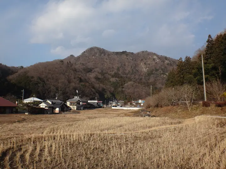
Namasefuji (406 m) rises north of Fukuroda Falls—one of Japan's three great waterfalls—in Daigo, Ibaraki Prefecture. Despite its modest height, it features successive rope- and chain-aided rock sections, and its knife-edge crest is nicknamed the "Gendarme of Ibaraki." The summit commands views of the Nasu, Nikko, and Takahara ranges and the town of Daigo, and it appears on lists such as "100 Hometown Fujis" and "100 Fujis of Japan."
Mt. Namasefuji at a glance
- Weather: The most settled day in the next 7 days is Fri, November 6: clear, gusts up to 10 m/s. Sat, Nov 7: strong wind (gusts up to 15 m/s).
- Route: The shortest is Namasefuji and Tategamiyama Rock Ridge Loop from Fukuroda Falls: about 3 h 39 min, 5.7 km, about 590 m of climbing.
Mt. Namasefuji weather (hourly, 14 days)
Sunrise today 06:03, sunset 16:41
| Tue, 11/3 | Wed, 11/4 | Thu, 11/5 | Fri, 11/6 | Sat, 11/7 | Sun, 11/8 | Mon, 11/9 | Tue, 11/10 | Wed, 11/11 | Thu, 11/12 | Fri, 11/13 | Sat, 11/14 | Sun, 11/15 | Mon, 11/16 | Tue, 11/17 | |||||||||||||||||||||||||||||||||||||||||||||||||||||||||||||||||||||||
|---|---|---|---|---|---|---|---|---|---|---|---|---|---|---|---|---|---|---|---|---|---|---|---|---|---|---|---|---|---|---|---|---|---|---|---|---|---|---|---|---|---|---|---|---|---|---|---|---|---|---|---|---|---|---|---|---|---|---|---|---|---|---|---|---|---|---|---|---|---|---|---|---|---|---|---|---|---|---|---|---|---|---|---|---|---|
| Japan time | 15 | 17 | 19 | 21 | 23 | 1 | 3 | 5 | 7 | 9 | 11 | 13 | 15 | 18 | 21 | 0 | 3 | 6 | 9 | 12 | 15 | 18 | 21 | 0 | 3 | 6 | 9 | 12 | 15 | 18 | 21 | 0 | 3 | 6 | 9 | 12 | 15 | 18 | 21 | 0 | 3 | 6 | 9 | 12 | 15 | 18 | 21 | 0 | 3 | 6 | 9 | 15 | 21 | 3 | 9 | 15 | 21 | 3 | 9 | 15 | 21 | 3 | 9 | 15 | 21 | 3 | 9 | 15 | 21 | 3 | 9 | 15 | 21 | 3 | 9 | 15 | 21 | 3 | 9 | 15 | 21 | 3 | 9 | 15 | |
  |   |   |  | | | |   | | |   | |   | | |   | | |   | | |   | | | | | |  | | | | | | | | | | | | | | | | | | | | | | | | | | |   | |   | | | | |  | | | | | | | | | | | | | | | | | | | | | | | ||
| Temperature | °C | 14° | 11° | 10° | 8° | 7° | 8° | 7° | 6° | 7° | 13° | 14° | 14° | 12° | 11° | 10° | 9° | 9° | 10° | 12° | 13° | 13° | 12° | 10° | 9° | 9° | 9° | 16° | 20° | 19° | 15° | 13° | 11° | 9° | 9° | 11° | 12° | 10° | 7° | 7° | 6° | 6° | 6° | 9° | 12° | 10° | 7° | 6° | 6° | 6° | 7° | 7° | 11° | 7° | 6° | 9° | 10° | 3° | 4° | 8° | 10° | 5° | 3° | 9° | 12° | 4° | 5° | 11° | 9° | 3° | 2° | 6° | 10° | 4° | 4° | 11° | 13° | 10° | 11° | 13° | 16° | 8° | 4° | 7° | 10° |
| Precipitation | mm | 2.6 | 5 | 8 | 17 | 10 | 1.6 | 0.9 | 0.3 | 1.2 | 4.3 | 17 | |||||||||||||||||||||||||||||||||||||||||||||||||||||||||||||||||||||||||
| New snow | cm | ||||||||||||||||||||||||||||||||||||||||||||||||||||||||||||||||||||||||||||||||||||
| Snow depth | cm | 0 | 0 | 0 | 0 | 0 | 0 | 0 | 0 | 0 | 0 | 0 | 0 | 0 | 0 | 0 | 0 | 0 | 0 | 0 | 0 | 0 | 0 | 0 | 0 | 0 | 0 | 0 | 0 | 0 | 0 | 0 | 0 | 0 | 0 | 0 | 0 | 0 | 0 | 0 | 0 | 0 | 0 | 0 | 0 | 0 | 0 | 0 | 0 | 0 | 0 | 0 | 0 | 0 | 0 | 0 | 0 | 0 | 0 | 0 | 0 | 0 | 0 | 0 | 0 | 0 | 0 | 0 | 0 | 0 | 0 | 0 | 0 | 0 | 0 | 0 | 0 | 0 | 0 | 0 | 0 | 0 | 0 | 0 | 0 |
| Wind | m/s | 4 | 3 | 3 | 3 | 3 | 1 | 1 | 2 | 2 | 0 | 0 | 2 | 3 | 1 | 1 | 2 | 3 | 3 | 4 | 5 | 3 | 1 | 1 | 1 | 1 | 1 | 0 | 3 | 4 | 4 | 5 | 5 | 5 | 5 | 5 | 6 | 6 | 5 | 6 | 6 | 6 | 5 | 6 | 5 | 4 | 3 | 3 | 2 | 2 | 3 | 2 | 2 | 3 | 2 | 3 | 3 | 1 | 1 | 5 | 7 | 2 | 3 | 2 | 2 | 1 | 1 | 4 | 4 | 3 | 3 | 1 | 2 | 0 | 1 | 1 | 4 | 1 | 1 | 1 | 6 | 4 | 4 | 2 | 3 |
| Wind gusts | m/s | 10 | 8 | 7 | 7 | 6 | 5 | 3 | 4 | 4 | 4 | 3 | 6 | 7 | 6 | 2 | 4 | 5 | 6 | 11 | 11 | 10 | 7 | 3 | 3 | 2 | 3 | 4 | 7 | 10 | 10 | 11 | 11 | 11 | 11 | 13 | 15 | 15 | 14 | 14 | 15 | 14 | 13 | 13 | 13 | 11 | 9 | 6 | 5 | 5 | 7 | 7 | 5 | 6 | 7 | 6 | 8 | 7 | 3 | 12 | 17 | 18 | 6 | 6 | 6 | 6 | 3 | 9 | 11 | 9 | 8 | 6 | 6 | 6 | 2 | 3 | 10 | 9 | 5 | 4 | 15 | 17 | 10 | 9 | 7 |
| Wind dir. | ↓ | ↓ | ↓ | ↓ | ↓ | ↓ | ↓ | ↓ | ↓ | ↓ | ↓ | ↓ | ↓ | ↓ | ↓ | ↓ | ↓ | ↓ | ↓ | ↓ | ↓ | ↓ | ↓ | ↓ | ↓ | ↓ | ↓ | ↓ | ↓ | ↓ | ↓ | ↓ | ↓ | ↓ | ↓ | ↓ | ↓ | ↓ | ↓ | ↓ | ↓ | ↓ | ↓ | ↓ | ↓ | ↓ | ↓ | ↓ | ↓ | ↓ | ↓ | ↓ | ↓ | ↓ | ↓ | ↓ | ↓ | ↓ | ↓ | ↓ | ↓ | ↓ | ↓ | ↓ | ↓ | ↓ | ↓ | ↓ | ↓ | ↓ | ↓ | ↓ | ↓ | ↓ | ↓ | ↓ | ↓ | ↓ | ↓ | ↓ | ↓ | ↓ | ↓ | ↓ | |
Mt. Namasefuji hiking routes
Hiking times are estimates calculated from the terrain.
Huts, campsites and lodging near Mt. Namasefuji
Mountain huts
- 奥の滝山荘
Lodging
- 滝美館
- 豊年万作
Lists that include Mt. Namasefuji
Mt. Namasefuji facts
- Elevation
- 406 m
- Location
- Daigo, Ibaraki
36.772013, 140.398364 - Website
- www.ibarakiguide.jp
- Wikipedia
- ja.wikipedia.org