
Mt. Myō
明山
Hitachiōmiya-shi, Ibaraki · Elevation 457 m
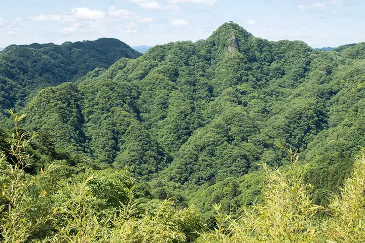
A 457.4-meter peak at Morozawa in Hitachi-Ōmiya City, Ibaraki Prefecture, set at the southern edge of the Oku-Kuji Prefectural Natural Park within the Kuji mountains of northern Ibaraki. The ridge is broken into rocky scrambles and rope sections that open to vistas of Kagōiwa-yama and Oku-Kuji Nantaisan, while the northern view drops to the great Ryūjin Suspension Bridge across the gorge. The peak forms one waypoint on the Hitachinokuni Long Trail's Okukuji section, and is reached from the Okukuji Panorama Line, the Morozawa trailhead and the Ryūjin Gorge side. Listed in the Bunken Tozan Guide for Ibaraki and Kantō-shūhen Yamanami-aruki.
Mt. Myō at a glance
- Weather: The most settled day in the next 7 days is Mon, November 9: clear, gusts up to 5 m/s. Sat, Nov 7: strong wind (gusts up to 16 m/s).
Mt. Myō weather (hourly, 14 days)
Sunrise today 06:03, sunset 16:41
| Tue, 11/3 | Wed, 11/4 | Thu, 11/5 | Fri, 11/6 | Sat, 11/7 | Sun, 11/8 | Mon, 11/9 | Tue, 11/10 | Wed, 11/11 | Thu, 11/12 | Fri, 11/13 | Sat, 11/14 | Sun, 11/15 | Mon, 11/16 | Tue, 11/17 | |||||||||||||||||||||||||||||||||||||||||||||||||||||||||||||||||||||||
|---|---|---|---|---|---|---|---|---|---|---|---|---|---|---|---|---|---|---|---|---|---|---|---|---|---|---|---|---|---|---|---|---|---|---|---|---|---|---|---|---|---|---|---|---|---|---|---|---|---|---|---|---|---|---|---|---|---|---|---|---|---|---|---|---|---|---|---|---|---|---|---|---|---|---|---|---|---|---|---|---|---|---|---|---|---|
| Japan time | 15 | 17 | 19 | 21 | 23 | 1 | 3 | 5 | 7 | 9 | 11 | 13 | 15 | 18 | 21 | 0 | 3 | 6 | 9 | 12 | 15 | 18 | 21 | 0 | 3 | 6 | 9 | 12 | 15 | 18 | 21 | 0 | 3 | 6 | 9 | 12 | 15 | 18 | 21 | 0 | 3 | 6 | 9 | 12 | 15 | 18 | 21 | 0 | 3 | 6 | 9 | 15 | 21 | 3 | 9 | 15 | 21 | 3 | 9 | 15 | 21 | 3 | 9 | 15 | 21 | 3 | 9 | 15 | 21 | 3 | 9 | 15 | 21 | 3 | 9 | 15 | 21 | 3 | 9 | 15 | 21 | 3 | 9 | 15 | |
  |   |   |  | |   | | | |   | | |   | | |   | | |   |   | |   |   | | | | |  | | | | | |  | | | | | | | | | | | | | | | | | | | | |   | | |   | | | |  | | | | | | | | | | | | | | | | | | | | | | | ||
| Temperature | °C | 14° | 10° | 9° | 7° | 7° | 8° | 8° | 7° | 6° | 12° | 14° | 12° | 11° | 11° | 10° | 9° | 10° | 11° | 12° | 13° | 14° | 11° | 10° | 9° | 9° | 9° | 15° | 19° | 19° | 13° | 13° | 11° | 9° | 9° | 11° | 12° | 10° | 7° | 7° | 6° | 6° | 6° | 9° | 12° | 10° | 7° | 6° | 6° | 6° | 6° | 6° | 9° | 6° | 5° | 8° | 8° | 2° | 3° | 8° | 10° | 5° | 4° | 9° | 11° | 3° | 4° | 11° | 10° | 4° | 1° | 6° | 10° | 3° | 2° | 11° | 13° | 10° | 11° | 13° | 16° | 8° | 3° | 7° | 8° |
| Precipitation | mm | 4.4 | 2.0 | 8 | 17 | 14 | 2.8 | 0.1 | 0.1 | 0.7 | 0.2 | 1.0 | 0.1 | 0.1 | 1.2 | 4.8 | 18 | ||||||||||||||||||||||||||||||||||||||||||||||||||||||||||||||||||||
| New snow | cm | ||||||||||||||||||||||||||||||||||||||||||||||||||||||||||||||||||||||||||||||||||||
| Snow depth | cm | 0 | 0 | 0 | 0 | 0 | 0 | 0 | 0 | 0 | 0 | 0 | 0 | 0 | 0 | 0 | 0 | 0 | 0 | 0 | 0 | 0 | 0 | 0 | 0 | 0 | 0 | 0 | 0 | 0 | 0 | 0 | 0 | 0 | 0 | 0 | 0 | 0 | 0 | 0 | 0 | 0 | 0 | 0 | 0 | 0 | 0 | 0 | 0 | 0 | 0 | 0 | 0 | 0 | 0 | 0 | 0 | 0 | 0 | 0 | 0 | 0 | 0 | 0 | 0 | 0 | 0 | 0 | 0 | 0 | 0 | 0 | 0 | 0 | 0 | 0 | 0 | 0 | 0 | 0 | 0 | 0 | 0 | 0 | 0 |
| Wind | m/s | 3 | 2 | 2 | 2 | 1 | 1 | 1 | 2 | 2 | 0 | 1 | 3 | 3 | 2 | 1 | 2 | 3 | 4 | 6 | 5 | 2 | 1 | 2 | 2 | 1 | 2 | 1 | 3 | 2 | 4 | 6 | 5 | 5 | 5 | 6 | 7 | 7 | 7 | 7 | 6 | 7 | 5 | 6 | 5 | 4 | 2 | 2 | 1 | 2 | 3 | 2 | 2 | 3 | 2 | 4 | 3 | 1 | 2 | 5 | 7 | 3 | 4 | 2 | 2 | 1 | 2 | 5 | 5 | 5 | 1 | 2 | 2 | 0 | 2 | 1 | 4 | 1 | 1 | 1 | 8 | 5 | 4 | 2 | 3 |
| Wind gusts | m/s | 10 | 7 | 4 | 4 | 4 | 2 | 2 | 3 | 4 | 4 | 4 | 7 | 7 | 6 | 4 | 4 | 6 | 7 | 12 | 11 | 10 | 3 | 4 | 4 | 4 | 4 | 4 | 7 | 7 | 6 | 12 | 13 | 12 | 11 | 14 | 15 | 16 | 16 | 15 | 14 | 15 | 14 | 14 | 14 | 11 | 8 | 5 | 5 | 4 | 5 | 5 | 5 | 6 | 7 | 8 | 10 | 8 | 5 | 11 | 16 | 15 | 8 | 8 | 7 | 6 | 3 | 11 | 12 | 11 | 9 | 5 | 6 | 6 | 4 | 4 | 10 | 9 | 6 | 4 | 17 | 19 | 11 | 9 | 8 |
| Wind dir. | ↓ | ↓ | ↓ | ↓ | ↓ | ↓ | ↓ | ↓ | ↓ | ↓ | ↓ | ↓ | ↓ | ↓ | ↓ | ↓ | ↓ | ↓ | ↓ | ↓ | ↓ | ↓ | ↓ | ↓ | ↓ | ↓ | ↓ | ↓ | ↓ | ↓ | ↓ | ↓ | ↓ | ↓ | ↓ | ↓ | ↓ | ↓ | ↓ | ↓ | ↓ | ↓ | ↓ | ↓ | ↓ | ↓ | ↓ | ↓ | ↓ | ↓ | ↓ | ↓ | ↓ | ↓ | ↓ | ↓ | ↓ | ↓ | ↓ | ↓ | ↓ | ↓ | ↓ | ↓ | ↓ | ↓ | ↓ | ↓ | ↓ | ↓ | ↓ | ↓ | ↓ | ↓ | ↓ | ↓ | ↓ | ↓ | ↓ | ↓ | ↓ | ↓ | ↓ | ↓ | |
Mt. Myō facts
- Also known as
- あけやま
- Elevation
- 457 m
- Location
- Hitachiōmiya-shi, Ibaraki
36.689603, 140.443388 - Website
- kenpokult.com
- Trail Map
- kenpokult.com (PDF)
- Wikipedia
- ja.wikipedia.org