
Mt. Tara
多良岳
Tara, Saga · Elevation 996 m
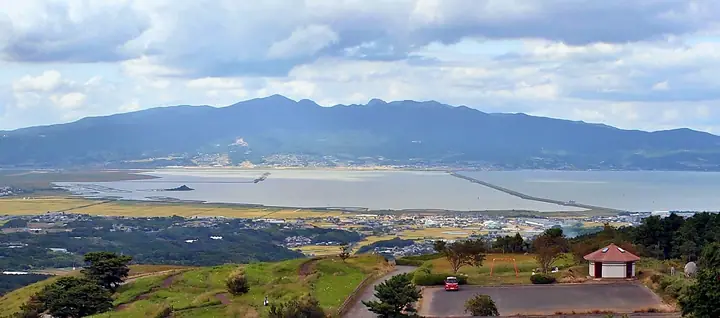
Mt. Tara (996 m) rises on the border of Tara Town (Saga Prefecture) and Isahaya, Ōmura and Unzen cities (Nagasaki Prefecture), and is the main peak of Tara-dake Prefectural Natural Park, included in the 300 Famous Mountains of Japan and the Kyushu 100 Famous Mountains. A Shugendō sanctuary opened in the early eighth century (708–715), the summit still preserves a small shrine to the Tara-dake Gongen, and the slopes shelter what is said to be Japan's finest stand of Ōkitsune-no-kamisori lilies as well as primeval evergreen oak and rare endemic plants such as the Shakunangan-pi. The standard routes climb from the Nakayama Campground on the Saga side and from the Kuroki trailhead via Konsen-ji Temple on the Nagasaki side.
Mt. Tara at a glance
- Weather: The most settled day in the next 7 days is Sun, November 8: cloudy, gusts up to 5 m/s.
- Route: The shortest is Kuroki Trailhead to Mount Tara via Kinsenji: about 4 h 8 min, 7.4 km, about 670 m of climbing.
Mt. Tara weather (hourly, 14 days)
Sunrise today 06:39, sunset 17:28
| Tue, 11/3 | Wed, 11/4 | Thu, 11/5 | Fri, 11/6 | Sat, 11/7 | Sun, 11/8 | Mon, 11/9 | Tue, 11/10 | Wed, 11/11 | Thu, 11/12 | Fri, 11/13 | Sat, 11/14 | Sun, 11/15 | Mon, 11/16 | Tue, 11/17 | |||||||||||||||||||||||||||||||||||||||||||||||||||||||||||||||||||||||
|---|---|---|---|---|---|---|---|---|---|---|---|---|---|---|---|---|---|---|---|---|---|---|---|---|---|---|---|---|---|---|---|---|---|---|---|---|---|---|---|---|---|---|---|---|---|---|---|---|---|---|---|---|---|---|---|---|---|---|---|---|---|---|---|---|---|---|---|---|---|---|---|---|---|---|---|---|---|---|---|---|---|---|---|---|---|
| Japan time | 15 | 17 | 19 | 21 | 23 | 1 | 3 | 5 | 7 | 9 | 11 | 13 | 15 | 18 | 21 | 0 | 3 | 6 | 9 | 12 | 15 | 18 | 21 | 0 | 3 | 6 | 9 | 12 | 15 | 18 | 21 | 0 | 3 | 6 | 9 | 12 | 15 | 18 | 21 | 0 | 3 | 6 | 9 | 12 | 15 | 18 | 21 | 0 | 3 | 6 | 9 | 15 | 21 | 3 | 9 | 15 | 21 | 3 | 9 | 15 | 21 | 3 | 9 | 15 | 21 | 3 | 9 | 15 | 21 | 3 | 9 | 15 | 21 | 3 | 9 | 15 | 21 | 3 | 9 | 15 | 21 | 3 | 9 | 15 | |
  |   |   |   | | | | | |   | |  | | | |   | | |   |   | | |   | |   |  | | | | | | | | | | | | | | | | | | | | | | | | | | |   | | | | | | | | | | | |  | | | | | | | | | | | | | | | |  | | | | ||
| Temperature | °C | 14° | 13° | 11° | 11° | 10° | 9° | 10° | 10° | 10° | 11° | 14° | 15° | 16° | 13° | 11° | 11° | 11° | 11° | 14° | 15° | 16° | 15° | 13° | 13° | 12° | 9° | 13° | 15° | 13° | 8° | 7° | 6° | 4° | 4° | 6° | 9° | 10° | 5° | 3° | 3° | 3° | 4° | 8° | 11° | 11° | 9° | 9° | 9° | 8° | 8° | 11° | 13° | 6° | 5° | 9° | 10° | 5° | 4° | 8° | 10° | 4° | 4° | 8° | 12° | 5° | 4° | 10° | 13° | 7° | 4° | 10° | 15° | 10° | 11° | 13° | 13° | 13° | 11° | 12° | 15° | 8° | 7° | 9° | 13° |
| Precipitation | mm | 0.8 | 1.1 | 0.1 | 4.8 | 6 | 0.6 | 0.1 | 0.2 | 0.1 | 1.7 | 14 | 4.4 | ||||||||||||||||||||||||||||||||||||||||||||||||||||||||||||||||||||||||
| New snow | cm | ||||||||||||||||||||||||||||||||||||||||||||||||||||||||||||||||||||||||||||||||||||
| Snow depth | cm | 0 | 0 | 0 | 0 | 0 | 0 | 0 | 0 | 0 | 0 | 0 | 0 | 0 | 0 | 0 | 0 | 0 | 0 | 0 | 0 | 0 | 0 | 0 | 0 | 0 | 0 | 0 | 0 | 0 | 0 | 0 | 0 | 0 | 0 | 0 | 0 | 0 | 0 | 0 | 0 | 0 | 0 | 0 | 0 | 0 | 0 | 0 | 0 | 0 | 0 | 0 | 0 | 0 | 0 | 0 | 0 | 0 | 0 | 0 | 0 | 0 | 0 | 0 | 0 | 0 | 0 | 0 | 0 | 0 | 0 | 0 | 0 | 0 | 0 | 0 | 0 | 0 | 0 | 0 | 0 | 0 | 0 | 0 | 0 |
| Wind | m/s | 3 | 3 | 3 | 3 | 3 | 3 | 3 | 3 | 3 | 2 | 2 | 1 | 0 | 1 | 1 | 1 | 1 | 2 | 2 | 4 | 4 | 4 | 3 | 4 | 3 | 3 | 3 | 5 | 5 | 3 | 3 | 4 | 4 | 4 | 4 | 4 | 3 | 2 | 1 | 1 | 1 | 1 | 1 | 1 | 2 | 1 | 1 | 1 | 1 | 2 | 3 | 4 | 2 | 2 | 3 | 5 | 2 | 3 | 3 | 3 | 1 | 0 | 1 | 2 | 1 | 1 | 1 | 2 | 2 | 1 | 2 | 1 | 2 | 2 | 4 | 3 | 1 | 2 | 4 | 4 | 2 | 3 | 3 | 3 |
| Wind gusts | m/s | 10 | 9 | 9 | 8 | 8 | 8 | 9 | 9 | 8 | 6 | 7 | 6 | 4 | 3 | 5 | 3 | 4 | 5 | 7 | 10 | 12 | 12 | 10 | 9 | 9 | 9 | 9 | 12 | 12 | 12 | 9 | 10 | 11 | 11 | 12 | 12 | 10 | 9 | 6 | 4 | 4 | 5 | 4 | 4 | 5 | 4 | 2 | 2 | 3 | 5 | 7 | 9 | 10 | 5 | 9 | 12 | 12 | 8 | 8 | 10 | 9 | 3 | 3 | 6 | 6 | 4 | 5 | 9 | 7 | 6 | 4 | 6 | 5 | 7 | 12 | 14 | 8 | 7 | 10 | 11 | 10 | 8 | 9 | 11 |
| Wind dir. | ↓ | ↓ | ↓ | ↓ | ↓ | ↓ | ↓ | ↓ | ↓ | ↓ | ↓ | ↓ | ↓ | ↓ | ↓ | ↓ | ↓ | ↓ | ↓ | ↓ | ↓ | ↓ | ↓ | ↓ | ↓ | ↓ | ↓ | ↓ | ↓ | ↓ | ↓ | ↓ | ↓ | ↓ | ↓ | ↓ | ↓ | ↓ | ↓ | ↓ | ↓ | ↓ | ↓ | ↓ | ↓ | ↓ | ↓ | ↓ | ↓ | ↓ | ↓ | ↓ | ↓ | ↓ | ↓ | ↓ | ↓ | ↓ | ↓ | ↓ | ↓ | ↓ | ↓ | ↓ | ↓ | ↓ | ↓ | ↓ | ↓ | ↓ | ↓ | ↓ | ↓ | ↓ | ↓ | ↓ | ↓ | ↓ | ↓ | ↓ | ↓ | ↓ | ↓ | ↓ | |
Mt. Tara hiking routes
Hiking times are estimates calculated from the terrain.
Huts, campsites and lodging near Mt. Tara
Mountain huts
Campsites
- 中山キャンプ場
- Hiratani Camping Ground
Lodging
- 自然の館ひらたに
Lists that include Mt. Tara
Japan's 300 Famous Mountains · Kyushu 100 Famous Mountains · Elevations of 1003 Mountains of Japan · 1000 Mountains of Japan
Mt. Tara facts
- Also known as
- 多良権現峰
- Elevation
- 996 m
- Location
- Tara, Saga
32.975616, 130.092770 - Website
- www.asobo-saga.jp
- Trail Map
- tara-kankou.jp (PDF)
- Wikipedia
- ja.wikipedia.org