
Mt. Takadateyama
高舘山
Tsuruoka, Yamagata · Elevation 274 m
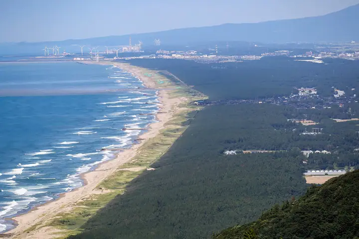
A 274 m hill rimming the Shōnai dunes on the Sea of Japan coast in western Tsuruoka City, cloaked in old-growth beech and oak. Designated a Forestry Agency "natural recreation forest" and one of the Ministry of the Environment's 100 Best Forests for Forest Bathing, it is managed as a single unit with the Ramsar-listed Ōyama upper and lower ponds at its foot. The standard route climbs from the Shimoike parking area on the Iwakura course, passing the Hachidai Ryūō shrine and a stand of large old trees. The peak is one of the Yamagata Hyakumeizan.
Mt. Takadateyama at a glance
- Weather: The most settled day in the next 7 days is Wed, November 4: rain, gusts up to 7 m/s. Fri, Nov 6, Sat, Nov 7, Sun, Nov 8: strong wind (gusts up to 23 m/s).
Mt. Takadateyama weather (hourly, 14 days)
Sunrise today 06:09, sunset 16:40
| Tue, 11/3 | Wed, 11/4 | Thu, 11/5 | Fri, 11/6 | Sat, 11/7 | Sun, 11/8 | Mon, 11/9 | Tue, 11/10 | Wed, 11/11 | Thu, 11/12 | Fri, 11/13 | Sat, 11/14 | Sun, 11/15 | Mon, 11/16 | Tue, 11/17 | |||||||||||||||||||||||||||||||||||||||||||||||||||||||||||||||||||||||
|---|---|---|---|---|---|---|---|---|---|---|---|---|---|---|---|---|---|---|---|---|---|---|---|---|---|---|---|---|---|---|---|---|---|---|---|---|---|---|---|---|---|---|---|---|---|---|---|---|---|---|---|---|---|---|---|---|---|---|---|---|---|---|---|---|---|---|---|---|---|---|---|---|---|---|---|---|---|---|---|---|---|---|---|---|---|
| Japan time | 15 | 17 | 19 | 21 | 23 | 1 | 3 | 5 | 7 | 9 | 11 | 13 | 15 | 18 | 21 | 0 | 3 | 6 | 9 | 12 | 15 | 18 | 21 | 0 | 3 | 6 | 9 | 12 | 15 | 18 | 21 | 0 | 3 | 6 | 9 | 12 | 15 | 18 | 21 | 0 | 3 | 6 | 9 | 12 | 15 | 18 | 21 | 0 | 3 | 6 | 9 | 15 | 21 | 3 | 9 | 15 | 21 | 3 | 9 | 15 | 21 | 3 | 9 | 15 | 21 | 3 | 9 | 15 | 21 | 3 | 9 | 15 | 21 | 3 | 9 | 15 | 21 | 3 | 9 | 15 | 21 | 3 | 9 | 15 | |
 |   | |   | |   | |   |   | |   | |   | | | | | | |   | | |   | |   | | | | | | | | | | | |   | | | | | | | | | | | | | |   | |   | | | | | | | | | | | | | | | | | | | | | |   | | | | | | | | | | ||
| Temperature | °C | 12° | 11° | 10° | 10° | 10° | 9° | 10° | 10° | 10° | 13° | 14° | 14° | 14° | 10° | 8° | 9° | 10° | 10° | 12° | 13° | 14° | 13° | 12° | 14° | 14° | 14° | 15° | 17° | 14° | 11° | 9° | 8° | 8° | 7° | 7° | 8° | 8° | 8° | 8° | 8° | 8° | 8° | 8° | 9° | 9° | 8° | 8° | 8° | 8° | 7° | 9° | 8° | 7° | 6° | 7° | 12° | 7° | 7° | 8° | 9° | 8° | 8° | 10° | 10° | 8° | 7° | 9° | 8° | 8° | 7° | 9° | 9° | 3° | 1° | 9° | 15° | 10° | 9° | 11° | 10° | 7° | 6° | 7° | 8° |
| Precipitation | mm | 0.2 | 0.2 | 0.3 | 0.3 | 0.8 | 0.4 | 0.6 | 0.1 | 0.1 | 1.4 | 2.7 | 1.7 | 0.3 | 2.1 | 1.0 | 3.8 | 8 | 2.5 | 4.0 | 3.2 | 3.2 | 3.5 | 2.3 | 1.8 | 2.0 | 1.6 | 1.0 | 0.6 | 0.8 | 0.8 | 1.1 | 1.1 | 0.4 | 0.4 | 0.3 | 0.2 | 0.1 | 1.2 | 11 | 15 | 5.0 | 0.9 | 2.3 | 1.1 | 0.5 | 0.4 | 15 | 2.0 | 0.3 | 0.4 | 0.1 | 0.1 | 1.8 | 3.4 | 4.7 | 6 | 1.0 | 0.2 | 0.2 | |||||||||||||||||||||||||
| New snow | cm | <.1 | |||||||||||||||||||||||||||||||||||||||||||||||||||||||||||||||||||||||||||||||||||
| Snow depth | cm | 0 | 0 | 0 | 0 | 0 | 0 | 0 | 0 | 0 | 0 | 0 | 0 | 0 | 0 | 0 | 0 | 0 | 0 | 0 | 0 | 0 | 0 | 0 | 0 | 0 | 0 | 0 | 0 | 0 | 0 | 0 | 0 | 0 | 0 | 0 | 0 | 0 | 0 | 0 | 0 | 0 | 0 | 0 | 0 | 0 | 0 | 0 | 0 | 0 | 0 | 0 | 0 | 0 | 0 | 0 | 0 | 0 | 0 | 0 | 0 | 0 | 0 | 0 | 0 | 0 | 0 | 0 | 0 | 0 | 0 | 0 | 0 | 0 | 0 | 0 | 0 | 0 | 0 | 0 | 0 | 0 | 0 | 0 | 0 |
| Wind | m/s | 5 | 4 | 4 | 2 | 2 | 2 | 2 | 3 | 3 | 4 | 3 | 2 | 2 | 2 | 2 | 2 | 2 | 3 | 2 | 3 | 5 | 1 | 2 | 3 | 3 | 5 | 6 | 8 | 6 | 7 | 8 | 7 | 9 | 10 | 11 | 13 | 12 | 11 | 11 | 9 | 10 | 9 | 9 | 9 | 8 | 6 | 4 | 4 | 4 | 1 | 2 | 4 | 2 | 1 | 4 | 5 | 6 | 3 | 1 | 6 | 4 | 3 | 5 | 4 | 4 | 2 | 6 | 7 | 5 | 3 | 3 | 2 | 2 | 1 | 1 | 1 | 3 | 2 | 1 | 9 | 8 | 5 | 1 | 2 |
| Wind gusts | m/s | 10 | 9 | 7 | 7 | 4 | 5 | 5 | 6 | 7 | 7 | 7 | 5 | 5 | 5 | 5 | 4 | 4 | 4 | 5 | 6 | 8 | 8 | 4 | 6 | 6 | 8 | 10 | 13 | 15 | 13 | 14 | 14 | 15 | 17 | 19 | 22 | 23 | 21 | 19 | 18 | 17 | 16 | 16 | 16 | 16 | 13 | 9 | 7 | 7 | 6 | 5 | 9 | 7 | 5 | 7 | 9 | 11 | 13 | 8 | 13 | 10 | 6 | 8 | 9 | 8 | 8 | 11 | 12 | 11 | 8 | 6 | 6 | 5 | 4 | 4 | 5 | 6 | 6 | 5 | 16 | 16 | 12 | 8 | 6 |
| Wind dir. | ↓ | ↓ | ↓ | ↓ | ↓ | ↓ | ↓ | ↓ | ↓ | ↓ | ↓ | ↓ | ↓ | ↓ | ↓ | ↓ | ↓ | ↓ | ↓ | ↓ | ↓ | ↓ | ↓ | ↓ | ↓ | ↓ | ↓ | ↓ | ↓ | ↓ | ↓ | ↓ | ↓ | ↓ | ↓ | ↓ | ↓ | ↓ | ↓ | ↓ | ↓ | ↓ | ↓ | ↓ | ↓ | ↓ | ↓ | ↓ | ↓ | ↓ | ↓ | ↓ | ↓ | ↓ | ↓ | ↓ | ↓ | ↓ | ↓ | ↓ | ↓ | ↓ | ↓ | ↓ | ↓ | ↓ | ↓ | ↓ | ↓ | ↓ | ↓ | ↓ | ↓ | ↓ | ↓ | ↓ | ↓ | ↓ | ↓ | ↓ | ↓ | ↓ | ↓ | ↓ | |
Huts, campsites and lodging near Mt. Takadateyama
Lodging
- Hotel Kameya
- Yukaitei Miyajima
- Yunohama Hotel
- Hotel Miyakoya
- Oogiya Ryokan
Lists that include Mt. Takadateyama
Yamagata 100 Famous Mountains · Elevations of 1003 Mountains of Japan
Mt. Takadateyama facts
- Elevation
- 274 m
- Location
- Tsuruoka, Yamagata
38.762931, 139.747488 - Website
- www.city.tsuruoka.lg.jp
- Trail Map
- www.city.tsuruoka.lg.jp (PDF)
- Access Information
- yamagatayama.com
- Wikipedia
- ja.wikipedia.org