
Mt. Sefuri
脊振山
Fukuoka, Fukuoka / Kanzaki, Saga · Elevation 1,054 m
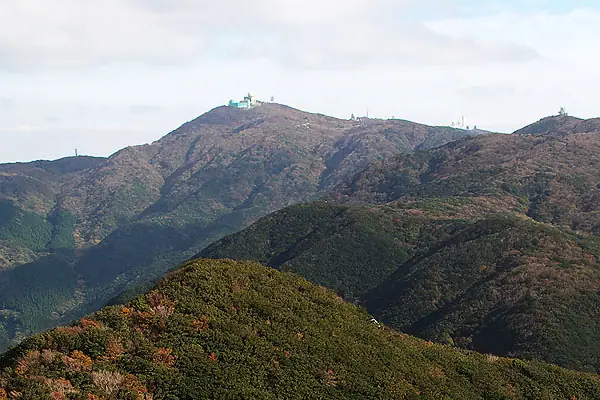
Mt. Sefuri (1,055 m) rises on the border of Sawara-ku, Fukuoka City, and Kanzaki City, Saga, as the principal summit of the Sefuri Range, with its surroundings designated Sefuri-Hokuzan Prefectural Natural Park. A long-revered site of mountain worship, the summit holds the upper shrine of Sefuri-jinja and now also a JASDF radar station; from the summit lookout the panorama sweeps from Fukuoka City and the Genkai Sea to the Saga Plain, Ariake Sea, and Mount Unzen beyond. Counted among Japan's 300 Famous Mountains and the 100 Famous Mountains of Kyūshū, it is traversed by the main line of the Kyūshū Long-Distance Nature Trail and reached by well-maintained routes from both the Fukuoka and Saga sides.
Mt. Sefuri at a glance
- Weather: The most settled day in the next 7 days is Sun, November 8: clear, gusts up to 5 m/s. Fri, Nov 6: strong wind (gusts up to 16 m/s).
- Route: The shortest is Mount Sefuri Circuit via Shiiba Pass, Tojin-no-Mai and Kurumatani: about 5 h 40 min, 10.7 km, about 740 m of climbing.
Mt. Sefuri weather (hourly, 14 days)
Sunrise today 06:38, sunset 17:26
| Tue, 11/3 | Wed, 11/4 | Thu, 11/5 | Fri, 11/6 | Sat, 11/7 | Sun, 11/8 | Mon, 11/9 | Tue, 11/10 | Wed, 11/11 | Thu, 11/12 | Fri, 11/13 | Sat, 11/14 | Sun, 11/15 | Mon, 11/16 | Tue, 11/17 | |||||||||||||||||||||||||||||||||||||||||||||||||||||||||||||||||||||||
|---|---|---|---|---|---|---|---|---|---|---|---|---|---|---|---|---|---|---|---|---|---|---|---|---|---|---|---|---|---|---|---|---|---|---|---|---|---|---|---|---|---|---|---|---|---|---|---|---|---|---|---|---|---|---|---|---|---|---|---|---|---|---|---|---|---|---|---|---|---|---|---|---|---|---|---|---|---|---|---|---|---|---|---|---|---|
| Japan time | 15 | 17 | 19 | 21 | 23 | 1 | 3 | 5 | 7 | 9 | 11 | 13 | 15 | 18 | 21 | 0 | 3 | 6 | 9 | 12 | 15 | 18 | 21 | 0 | 3 | 6 | 9 | 12 | 15 | 18 | 21 | 0 | 3 | 6 | 9 | 12 | 15 | 18 | 21 | 0 | 3 | 6 | 9 | 12 | 15 | 18 | 21 | 0 | 3 | 6 | 9 | 15 | 21 | 3 | 9 | 15 | 21 | 3 | 9 | 15 | 21 | 3 | 9 | 15 | 21 | 3 | 9 | 15 | 21 | 3 | 9 | 15 | 21 | 3 | 9 | 15 | 21 | 3 | 9 | 15 | 21 | 3 | 9 | 15 | |
  |   |   | | |   | | | |   | | | |   | | | | | |   | |   | | |   | | |   |  |  | | | | | | | | | | | | | | | | | | | | |   | | | | | |   | | | |   | | | |  | | | | | | | | | | | | | | | | | | | | ||
| Temperature | °C | 12° | 11° | 9° | 9° | 9° | 8° | 8° | 8° | 7° | 9° | 13° | 15° | 14° | 10° | 11° | 10° | 11° | 11° | 13° | 14° | 15° | 13° | 13° | 12° | 11° | 9° | 12° | 12° | 10° | 7° | 6° | 5° | 4° | 4° | 6° | 7° | 7° | 3° | 3° | 3° | 3° | 3° | 7° | 9° | 10° | 8° | 7° | 7° | 7° | 6° | 9° | 10° | 5° | 5° | 8° | 9° | 7° | 5° | 6° | 8° | 3° | 2° | 8° | 10° | 4° | 5° | 10° | 11° | 6° | 5° | 8° | 14° | 9° | 9° | 10° | 12° | 10° | 11° | 11° | 12° | 7° | 6° | 8° | 11° |
| Precipitation | mm | 0.7 | 0.8 | 0.2 | 2.2 | 1.3 | 2.4 | 0.6 | 0.7 | 1.1 | 0.2 | 0.2 | 0.6 | 0.2 | 0.5 | 1.0 | 0.2 | 0.5 | 8 | 17 | 11 | 1.7 | 2.3 | 0.3 | 0.3 | ||||||||||||||||||||||||||||||||||||||||||||||||||||||||||||
| New snow | cm | ||||||||||||||||||||||||||||||||||||||||||||||||||||||||||||||||||||||||||||||||||||
| Snow depth | cm | 0 | 0 | 0 | 0 | 0 | 0 | 0 | 0 | 0 | 0 | 0 | 0 | 0 | 0 | 0 | 0 | 0 | 0 | 0 | 0 | 0 | 0 | 0 | 0 | 0 | 0 | 0 | 0 | 0 | 0 | 0 | 0 | 0 | 0 | 0 | 0 | 0 | 0 | 0 | 0 | 0 | 0 | 0 | 0 | 0 | 0 | 0 | 0 | 0 | 0 | 0 | 0 | 0 | 0 | 0 | 0 | 0 | 0 | 0 | 0 | 0 | 0 | 0 | 0 | 0 | 0 | 0 | 0 | 0 | 0 | 0 | 0 | 0 | 0 | 0 | 0 | 0 | 0 | 0 | 0 | 0 | 0 | 0 | 0 |
| Wind | m/s | 4 | 3 | 2 | 2 | 2 | 2 | 2 | 2 | 1 | 1 | 2 | 1 | 2 | 1 | 1 | 1 | 1 | 1 | 2 | 4 | 3 | 2 | 2 | 2 | 4 | 4 | 4 | 6 | 5 | 4 | 4 | 5 | 5 | 5 | 5 | 4 | 4 | 2 | 1 | 1 | 1 | 1 | 1 | 1 | 2 | 1 | 0 | 1 | 1 | 1 | 2 | 4 | 1 | 1 | 3 | 5 | 3 | 3 | 3 | 4 | 0 | 0 | 0 | 2 | 1 | 1 | 2 | 3 | 1 | 1 | 1 | 2 | 1 | 2 | 5 | 3 | 1 | 2 | 3 | 5 | 3 | 2 | 3 | 4 |
| Wind gusts | m/s | 11 | 10 | 8 | 7 | 7 | 7 | 6 | 7 | 5 | 5 | 7 | 6 | 6 | 6 | 5 | 5 | 4 | 3 | 7 | 13 | 15 | 9 | 8 | 8 | 11 | 11 | 11 | 15 | 16 | 14 | 11 | 15 | 15 | 14 | 14 | 14 | 13 | 11 | 5 | 4 | 4 | 4 | 4 | 5 | 5 | 4 | 3 | 2 | 4 | 6 | 6 | 11 | 11 | 5 | 9 | 14 | 14 | 12 | 10 | 11 | 10 | 2 | 3 | 7 | 7 | 4 | 6 | 8 | 8 | 4 | 5 | 9 | 7 | 6 | 14 | 16 | 10 | 7 | 9 | 13 | 13 | 8 | 7 | 10 |
| Wind dir. | ↓ | ↓ | ↓ | ↓ | ↓ | ↓ | ↓ | ↓ | ↓ | ↓ | ↓ | ↓ | ↓ | ↓ | ↓ | ↓ | ↓ | ↓ | ↓ | ↓ | ↓ | ↓ | ↓ | ↓ | ↓ | ↓ | ↓ | ↓ | ↓ | ↓ | ↓ | ↓ | ↓ | ↓ | ↓ | ↓ | ↓ | ↓ | ↓ | ↓ | ↓ | ↓ | ↓ | ↓ | ↓ | ↓ | ↓ | ↓ | ↓ | ↓ | ↓ | ↓ | ↓ | ↓ | ↓ | ↓ | ↓ | ↓ | ↓ | ↓ | ↓ | ↓ | ↓ | ↓ | ↓ | ↓ | ↓ | ↓ | ↓ | ↓ | ↓ | ↓ | ↓ | ↓ | ↓ | ↓ | ↓ | ↓ | ↓ | ↓ | ↓ | ↓ | ↓ | ↓ | |
Mt. Sefuri hiking routes
Hiking times are estimates calculated from the terrain.
Lists that include Mt. Sefuri
Japan's 300 Famous Mountains · Kyushu 100 Famous Mountains · Elevations of 1003 Mountains of Japan · 1000 Mountains of Japan
Mt. Sefuri facts
- Also known as
- 背振山
- Elevation
- 1,054 m
- Location
- Fukuoka, Fukuoka / Kanzaki, Saga
33.436370, 130.368657 - Website
- sagamichi.jp
- Trail Map
- sagamichi.jp (PDF)
- Wikipedia
- ja.wikipedia.org