
Mt. Ryōzen
霊仙山
Taga, Shiga · Elevation 1,083 m
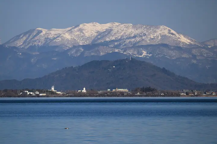
Mt. Ryōzen (1,084 m) is the northernmost summit of the Suzuka Range, straddling Maibara City and Taga Town in Shiga and Ōgaki City and Sekigahara Town in Gifu, and incorporated into the special district of Lake Biwa Quasi-National Park in 1950. Its summit plateau is a karst landscape of dissolved limestone, dotted with dolines, and so rich in alpine flowers—Fukujusō, Yamashakuyaku, and many others—that it earned a place on Sumie Tanaka's "100 Flower Mountains." From the top, the panorama sweeps 360 degrees from Lake Biwa across to Ise Bay and on to Mt. Haku and Mt. Ontake. Trails climb from Samegai-yōsonjō / Kuregahata, Kashiwara, and Imahata.
Mt. Ryōzen at a glance
- Weather: The most settled day in the next 7 days is Wed, November 4: clear, gusts up to 5 m/s. Fri, Nov 6, Sat, Nov 7: strong wind (gusts up to 19 m/s).
- Route: The shortest is Mount Ryozen Loop from Imahata Trailhead: about 6 h 8 min, 10.0 km, about 860 m of climbing.
Mt. Ryōzen weather (hourly, 14 days)
Sunrise today 06:17, sunset 16:59
| Tue, 11/3 | Wed, 11/4 | Thu, 11/5 | Fri, 11/6 | Sat, 11/7 | Sun, 11/8 | Mon, 11/9 | Tue, 11/10 | Wed, 11/11 | Thu, 11/12 | Fri, 11/13 | Sat, 11/14 | Sun, 11/15 | Mon, 11/16 | Tue, 11/17 | |||||||||||||||||||||||||||||||||||||||||||||||||||||||||||||||||||||||
|---|---|---|---|---|---|---|---|---|---|---|---|---|---|---|---|---|---|---|---|---|---|---|---|---|---|---|---|---|---|---|---|---|---|---|---|---|---|---|---|---|---|---|---|---|---|---|---|---|---|---|---|---|---|---|---|---|---|---|---|---|---|---|---|---|---|---|---|---|---|---|---|---|---|---|---|---|---|---|---|---|---|---|---|---|---|
| Japan time | 15 | 17 | 19 | 21 | 23 | 1 | 3 | 5 | 7 | 9 | 11 | 13 | 15 | 18 | 21 | 0 | 3 | 6 | 9 | 12 | 15 | 18 | 21 | 0 | 3 | 6 | 9 | 12 | 15 | 18 | 21 | 0 | 3 | 6 | 9 | 12 | 15 | 18 | 21 | 0 | 3 | 6 | 9 | 12 | 15 | 18 | 21 | 0 | 3 | 6 | 9 | 15 | 21 | 3 | 9 | 15 | 21 | 3 | 9 | 15 | 21 | 3 | 9 | 15 | 21 | 3 | 9 | 15 | 21 | 3 | 9 | 15 | 21 | 3 | 9 | 15 | 21 | 3 | 9 | 15 | 21 | 3 | 9 | 15 | |
 |   | | | | | | |   | | | |   |   | |   | | |   |   |   | | |   | | | | | |  | |   | | | | | | | | | | | | | | | | | | | | |   | | | |   | | | | |  | | | | | | | | | | | | | |   | | | | | | | | | ||
| Temperature | °C | 12° | 10° | 7° | 7° | 6° | 5° | 5° | 4° | 5° | 9° | 13° | 14° | 13° | 11° | 10° | 9° | 9° | 8° | 11° | 12° | 14° | 11° | 10° | 10° | 11° | 10° | 10° | 14° | 12° | 9° | 8° | 6° | 5° | 5° | 5° | 6° | 6° | 4° | 4° | 3° | 3° | 3° | 6° | 8° | 8° | 6° | 5° | 5° | 5° | 5° | 7° | 9° | 5° | 2° | 9° | 10° | 5° | 3° | 6° | 6° | 3° | 1° | 6° | 8° | 3° | 4° | 6° | 7° | 2° | 1° | 7° | 11° | 6° | 6° | 9° | 10° | 9° | 9° | 10° | 11° | 4° | 2° | 4° | 7° |
| Precipitation | mm | 6 | 2.9 | 0.9 | 1.0 | 0.2 | 2.6 | 0.8 | 1.6 | 0.5 | 0.5 | 0.4 | 0.5 | 1.3 | 1.1 | 0.4 | 0.1 | 1.6 | 1.9 | 1.0 | 1.1 | 2.7 | 6 | 0.4 | 1.0 | ||||||||||||||||||||||||||||||||||||||||||||||||||||||||||||
| New snow | cm | ||||||||||||||||||||||||||||||||||||||||||||||||||||||||||||||||||||||||||||||||||||
| Snow depth | cm | 0 | 0 | 0 | 0 | 0 | 0 | 0 | 0 | 0 | 0 | 0 | 0 | 0 | 0 | 0 | 0 | 0 | 0 | 0 | 0 | 0 | 0 | 0 | 0 | 0 | 0 | 0 | 0 | 0 | 0 | 0 | 0 | 0 | 0 | 0 | 0 | 0 | 0 | 0 | 0 | 0 | 0 | 0 | 0 | 0 | 0 | 0 | 0 | 0 | 0 | 0 | 0 | 0 | 0 | 0 | 0 | 0 | 0 | 0 | 0 | 0 | 0 | 0 | 0 | 0 | 0 | 0 | 0 | 0 | 0 | 0 | 0 | 0 | 0 | 0 | 0 | 0 | 0 | 0 | 0 | 0 | 0 | 0 | 0 |
| Wind | m/s | 5 | 4 | 2 | 2 | 1 | 1 | 1 | 1 | 1 | 1 | 1 | 0 | 1 | 1 | 1 | 1 | 1 | 0 | 0 | 1 | 1 | 0 | 2 | 1 | 2 | 4 | 5 | 6 | 8 | 7 | 6 | 7 | 6 | 7 | 6 | 7 | 6 | 5 | 4 | 3 | 2 | 1 | 3 | 5 | 4 | 2 | 1 | 1 | 1 | 1 | 2 | 4 | 1 | 2 | 1 | 4 | 4 | 7 | 7 | 7 | 3 | 2 | 3 | 4 | 1 | 1 | 4 | 6 | 3 | 1 | 0 | 0 | 2 | 2 | 2 | 3 | 3 | 1 | 3 | 6 | 3 | 4 | 3 | 2 |
| Wind gusts | m/s | 11 | 11 | 9 | 6 | 5 | 4 | 4 | 4 | 3 | 4 | 4 | 5 | 4 | 4 | 6 | 7 | 7 | 4 | 3 | 3 | 4 | 4 | 4 | 5 | 6 | 9 | 13 | 16 | 19 | 18 | 17 | 16 | 16 | 17 | 16 | 17 | 17 | 16 | 13 | 9 | 8 | 7 | 8 | 13 | 13 | 10 | 6 | 3 | 3 | 4 | 6 | 12 | 11 | 5 | 5 | 12 | 12 | 18 | 17 | 18 | 17 | 9 | 7 | 11 | 10 | 8 | 10 | 16 | 15 | 7 | 3 | 5 | 6 | 5 | 7 | 9 | 9 | 8 | 8 | 16 | 16 | 11 | 10 | 7 |
| Wind dir. | ↓ | ↓ | ↓ | ↓ | ↓ | ↓ | ↓ | ↓ | ↓ | ↓ | ↓ | ↓ | ↓ | ↓ | ↓ | ↓ | ↓ | ↓ | ↓ | ↓ | ↓ | ↓ | ↓ | ↓ | ↓ | ↓ | ↓ | ↓ | ↓ | ↓ | ↓ | ↓ | ↓ | ↓ | ↓ | ↓ | ↓ | ↓ | ↓ | ↓ | ↓ | ↓ | ↓ | ↓ | ↓ | ↓ | ↓ | ↓ | ↓ | ↓ | ↓ | ↓ | ↓ | ↓ | ↓ | ↓ | ↓ | ↓ | ↓ | ↓ | ↓ | ↓ | ↓ | ↓ | ↓ | ↓ | ↓ | ↓ | ↓ | ↓ | ↓ | ↓ | ↓ | ↓ | ↓ | ↓ | ↓ | ↓ | ↓ | ↓ | ↓ | ↓ | ↓ | ↓ | |
Mt. Ryōzen hiking routes
Hiking times are estimates calculated from the terrain.
Huts, campsites and lodging near Mt. Ryōzen
Mountain huts
- 霊仙山避難小屋 unstaffed
- 4合目緊急避難小屋
Lists that include Mt. Ryōzen
100 Famous Mountains of Flowers · 100 Low Mountains of Japan · Kansai 100 Famous Mountains · Tokai 100 Mountains · Kinki 100 Famous Mountains · Omi 100 Mountains · Elevations of 1003 Mountains of Japan · 1000 Mountains of Japan
Mt. Ryōzen facts
- Elevation
- 1,083 m
- Location
- Taga, Shiga
35.280480, 136.376762 - National Park
- 琵琶湖国定公園
- Website
- www.city.maibara.lg.jp
- Trail Map
- www.city.maibara.lg.jp (PDF)
- Wikipedia
- ja.wikipedia.org