
Mt. Pinneshiri
ピンネシリ
Shintotsukawa, Hokkaido · Elevation 1,100 m
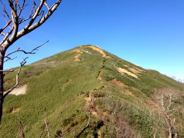
Mt. Pinneshiri is a 1,100.3-meter peak on the border between Shintotsukawa Town in Kabato District and Tobetsu Town in Ishikari District, Hokkaido — the highest summit of the Kabato Mountains and, together with Mt. Kamuishirisan and Mt. Kumaneshirisan, one of the three peaks of "Kabato-Sanzan." The name is Ainu for "male mountain," paired with the lower neighbouring Matsuneshiri ("female mountain"). Two trails reach the summit, which hosts a Japan Air Self-Defense Force radar station: the Sakinzawa route from Shintotsukawa and the Ichibangawa route from the Domin-no-Mori park on the Tobetsu side. The mountain is featured in the Hokkaido Hyakumeizan list.
Mt. Pinneshiri at a glance
- Weather: The most settled day in the next 7 days is Thu, November 5: clear, gusts up to 11 m/s. Sat, Nov 7, Sun, Nov 8: strong wind (gusts up to 20 m/s).
Mt. Pinneshiri weather (hourly, 14 days)
Sunrise today 06:10, sunset 16:24
| Tue, 11/3 | Wed, 11/4 | Thu, 11/5 | Fri, 11/6 | Sat, 11/7 | Sun, 11/8 | Mon, 11/9 | Tue, 11/10 | Wed, 11/11 | Thu, 11/12 | Fri, 11/13 | Sat, 11/14 | Sun, 11/15 | Mon, 11/16 | Tue, 11/17 | |||||||||||||||||||||||||||||||||||||||||||||||||||||||||||||||||||||||
|---|---|---|---|---|---|---|---|---|---|---|---|---|---|---|---|---|---|---|---|---|---|---|---|---|---|---|---|---|---|---|---|---|---|---|---|---|---|---|---|---|---|---|---|---|---|---|---|---|---|---|---|---|---|---|---|---|---|---|---|---|---|---|---|---|---|---|---|---|---|---|---|---|---|---|---|---|---|---|---|---|---|---|---|---|---|
| Japan time | 15 | 17 | 19 | 21 | 23 | 1 | 3 | 5 | 7 | 9 | 11 | 13 | 15 | 18 | 21 | 0 | 3 | 6 | 9 | 12 | 15 | 18 | 21 | 0 | 3 | 6 | 9 | 12 | 15 | 18 | 21 | 0 | 3 | 6 | 9 | 12 | 15 | 18 | 21 | 0 | 3 | 6 | 9 | 12 | 15 | 18 | 21 | 0 | 3 | 6 | 9 | 15 | 21 | 3 | 9 | 15 | 21 | 3 | 9 | 15 | 21 | 3 | 9 | 15 | 21 | 3 | 9 | 15 | 21 | 3 | 9 | 15 | 21 | 3 | 9 | 15 | 21 | 3 | 9 | 15 | 21 | 3 | 9 | 15 | |
  |   |   |   | | | |   |   | | |  | |  | | | | | | | |   |   |   | | |   |   | |   | |   | | |   | |   | | | | | | | | | | | | | |   |   | | | | | | | | | | | |   | | | | |   | | | | | | | | | | |   | | | | | ||
| Temperature | °C | -1° | -4° | -4° | -5° | -5° | -4° | -5° | -4° | -2° | 0° | 1° | 1° | 0° | -4° | -4° | -4° | -3° | -2° | 4° | 8° | 8° | 4° | 3° | 3° | 2° | 3° | 6° | 10° | 6° | 2° | -2° | -4° | -5° | -5° | -5° | -5° | -5° | -5° | -5° | -6° | -6° | -6° | -5° | -4° | -4° | -5° | -5° | -6° | -6° | -6° | -4° | -5° | -10° | -9° | -6° | -5° | -9° | -8° | -4° | -2° | -7° | -6° | -4° | -3° | -5° | -8° | -6° | -4° | -8° | -11° | -5° | -1° | -7° | -4° | 0° | 2° | 1° | 1° | -1° | -1° | -6° | -6° | -2° | -2° |
| Precipitation | mm | 0.2 | 0.2 | 0.2 | 2.9 | 1.3 | 0.6 | 0.7 | 9 | 4.0 | 1.0 | 0.6 | 1.3 | 1.1 | 0.5 | 1.0 | 0.8 | 1.4 | 2.0 | 1.9 | 1.2 | 1.0 | 1.2 | 1.2 | 1.3 | 1.2 | 1.3 | 1.4 | 0.7 | 0.5 | 0.3 | 0.1 | 0.1 | 0.3 | 1.2 | 0.8 | 0.2 | 0.3 | 0.2 | 0.8 | 1.4 | 0.1 | 0.2 | 0.8 | 0.8 | 0.4 | 4.8 | 4.1 | 2.5 | ||||||||||||||||||||||||||||||||||||
| New snow | cm | <.1 | 0.2 | 0.1 | 0.2 | 2.9 | 1.3 | 0.4 | 0.5 | 0.8 | 1.4 | 2.0 | 1.9 | 1.2 | 1.0 | 1.2 | 1.2 | 1.3 | 1.2 | 1.3 | 1.4 | 0.7 | 0.5 | 0.3 | 0.1 | <.1 | <.1 | 0.1 | 0.2 | 1.2 | 0.8 | 0.2 | 0.3 | 0.2 | <.1 | 0.8 | 1.0 | <.1 | 0.1 | 0.2 | <.1 | 0.8 | <.1 | <.1 | |||||||||||||||||||||||||||||||||||||||||
| Snow depth | cm | 0 | 0 | 0 | 0 | 0 | 2 | 3 | 3 | 3 | 3 | 2 | 2 | <1 | <1 | <1 | <1 | <1 | <1 | <1 | <1 | <1 | 0 | 0 | 0 | 0 | 0 | 0 | 0 | 0 | 0 | 0 | <1 | <1 | 2 | 3 | 4 | 4 | 5 | 5 | 6 | 6 | 7 | 8 | 8 | 8 | 8 | 9 | 9 | 9 | 9 | 8 | 8 | 8 | 9 | 10 | 9 | 9 | 9 | 10 | 9 | 9 | 9 | 10 | 9 | 9 | 9 | 9 | 9 | 9 | 9 | 9 | 8 | 8 | 8 | 7 | 4 | 2 | 1 | 1 | <1 | <1 | <1 | <1 | <1 |
| Wind | m/s | 5 | 1 | 1 | 1 | 2 | 4 | 2 | 2 | 5 | 5 | 4 | 4 | 2 | 2 | 2 | 2 | 3 | 2 | 4 | 4 | 2 | 1 | 1 | 1 | 1 | 1 | 4 | 4 | 4 | 7 | 5 | 6 | 5 | 5 | 6 | 7 | 5 | 6 | 8 | 8 | 7 | 7 | 7 | 6 | 5 | 3 | 2 | 2 | 2 | 2 | 4 | 3 | 1 | 1 | 1 | 1 | 2 | 3 | 2 | 0 | 1 | 1 | 1 | 3 | 2 | 1 | 3 | 2 | 1 | 1 | 0 | 1 | 1 | 2 | 4 | 3 | 3 | 3 | 2 | 3 | 1 | 2 | 1 | 3 |
| Wind gusts | m/s | 14 | 11 | 5 | 6 | 7 | 11 | 11 | 8 | 13 | 14 | 12 | 10 | 10 | 6 | 7 | 8 | 9 | 9 | 11 | 10 | 10 | 6 | 4 | 3 | 4 | 5 | 11 | 13 | 13 | 17 | 17 | 18 | 17 | 16 | 17 | 20 | 19 | 18 | 20 | 21 | 20 | 19 | 18 | 18 | 18 | 14 | 10 | 7 | 7 | 7 | 10 | 11 | 9 | 4 | 4 | 5 | 6 | 7 | 7 | 6 | 4 | 4 | 5 | 10 | 8 | 6 | 9 | 10 | 6 | 6 | 3 | 5 | 5 | 6 | 10 | 11 | 10 | 10 | 8 | 7 | 8 | 6 | 6 | 8 |
| Wind dir. | ↓ | ↓ | ↓ | ↓ | ↓ | ↓ | ↓ | ↓ | ↓ | ↓ | ↓ | ↓ | ↓ | ↓ | ↓ | ↓ | ↓ | ↓ | ↓ | ↓ | ↓ | ↓ | ↓ | ↓ | ↓ | ↓ | ↓ | ↓ | ↓ | ↓ | ↓ | ↓ | ↓ | ↓ | ↓ | ↓ | ↓ | ↓ | ↓ | ↓ | ↓ | ↓ | ↓ | ↓ | ↓ | ↓ | ↓ | ↓ | ↓ | ↓ | ↓ | ↓ | ↓ | ↓ | ↓ | ↓ | ↓ | ↓ | ↓ | ↓ | ↓ | ↓ | ↓ | ↓ | ↓ | ↓ | ↓ | ↓ | ↓ | ↓ | ↓ | ↓ | ↓ | ↓ | ↓ | ↓ | ↓ | ↓ | ↓ | ↓ | ↓ | ↓ | ↓ | ↓ | |
Huts, campsites and lodging near Mt. Pinneshiri
Mountain huts
Lists that include Mt. Pinneshiri
Hokkaido 100 Famous Mountains · Elevations of 1003 Mountains of Japan
Mt. Pinneshiri facts
- Also known as
- 賓根知山
- Elevation
- 1,100 m
- Location
- Shintotsukawa, Hokkaido
43.491783, 141.706740 - Website
- www.town.shintotsukawa.lg.jp
- Trail Map
- www.town.shintotsukawa.lg.jp
- Access Information
- www.town.shintotsukawa.lg.jp
- Wikipedia
- ja.wikipedia.org