
Mt. Oyasan
大野山
Inagawa, Hyogo / Tamba-Sasayama, Hyogo · Elevation 753 m
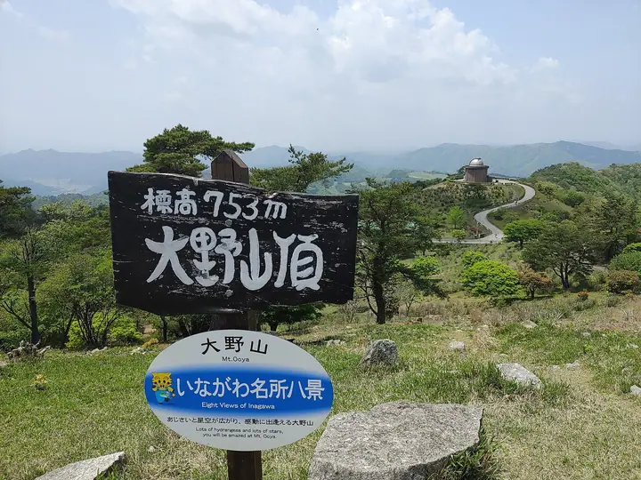
Oyasan is a 753.49-meter peak in the northern part of Inagawa Town, Kawabe District, Hyogo Prefecture, known as the highest mountain in the Hanshin region. The summit area is developed as 'Oya Alps Land', a park run by the town that includes the Inagawa Astronomical Observatory 'Astropia', a campground, and the Iwameguri rock-tour hiking trail. Some 16,000 hydrangea shrubs are planted around the summit, drawing crowds at peak bloom in late June and early July. The peak is included in 'Furusato Hyogo Hyakuzan'.
Mt. Oyasan at a glance
- Weather: The most settled day in the next 7 days is Wed, November 4: cloudy, gusts up to 9 m/s. Sat, Nov 7: strong wind (gusts up to 15 m/s).
Mt. Oyasan weather (hourly, 14 days)
Sunrise today 06:21, sunset 17:04
| Tue, 11/3 | Wed, 11/4 | Thu, 11/5 | Fri, 11/6 | Sat, 11/7 | Sun, 11/8 | Mon, 11/9 | Tue, 11/10 | Wed, 11/11 | Thu, 11/12 | Fri, 11/13 | Sat, 11/14 | Sun, 11/15 | Mon, 11/16 | Tue, 11/17 | |||||||||||||||||||||||||||||||||||||||||||||||||||||||||||||||||||||||
|---|---|---|---|---|---|---|---|---|---|---|---|---|---|---|---|---|---|---|---|---|---|---|---|---|---|---|---|---|---|---|---|---|---|---|---|---|---|---|---|---|---|---|---|---|---|---|---|---|---|---|---|---|---|---|---|---|---|---|---|---|---|---|---|---|---|---|---|---|---|---|---|---|---|---|---|---|---|---|---|---|---|---|---|---|---|
| Japan time | 21 | 23 | 1 | 3 | 5 | 7 | 9 | 11 | 13 | 15 | 17 | 19 | 21 | 0 | 3 | 6 | 9 | 12 | 15 | 18 | 21 | 0 | 3 | 6 | 9 | 12 | 15 | 18 | 21 | 0 | 3 | 6 | 9 | 12 | 15 | 18 | 21 | 0 | 3 | 6 | 9 | 12 | 15 | 18 | 21 | 0 | 3 | 6 | 9 | 12 | 15 | 21 | 3 | 9 | 15 | 21 | 3 | 9 | 15 | 21 | 3 | 9 | 15 | 21 | 3 | 9 | 15 | 21 | 3 | 9 | 15 | 21 | 3 | 9 | 15 | 21 | 3 | 9 | 15 | 21 | 3 | 9 | 15 | 21 | |
  | | | |   |   | |   | | |   |   | |   | | | |   | |   | |   | | | |   | | | | |  | | | | | | | | | | | | | | | | | |  | | |   | | | | | | | | |  | | | | |   | | | | | | | | | | | | | | | | | |  | ||
| Temperature | °C | 8° | 8° | 7° | 7° | 7° | 7° | 11° | 14° | 13° | 14° | 11° | 10° | 12° | 11° | 11° | 11° | 13° | 18° | 19° | 14° | 13° | 14° | 12° | 10° | 12° | 16° | 15° | 10° | 8° | 7° | 6° | 5° | 8° | 9° | 8° | 6° | 5° | 5° | 5° | 5° | 8° | 9° | 9° | 6° | 7° | 6° | 6° | 6° | 10° | 13° | 12° | 6° | 4° | 9° | 11° | 5° | 5° | 8° | 8° | 4° | 2° | 8° | 11° | 5° | 5° | 8° | 9° | 4° | 3° | 8° | 13° | 6° | 6° | 11° | 12° | 11° | 11° | 12° | 12° | 7° | 4° | 7° | 9° | 4° |
| Precipitation | mm | 0.7 | 0.5 | 2.4 | 1.3 | 0.3 | 0.3 | 0.3 | 0.3 | 0.3 | 0.6 | 0.4 | 0.7 | 0.2 | 0.1 | 0.1 | 0.3 | 4.1 | 1.9 | 0.4 | 1.7 | 0.4 | |||||||||||||||||||||||||||||||||||||||||||||||||||||||||||||||
| New snow | cm | ||||||||||||||||||||||||||||||||||||||||||||||||||||||||||||||||||||||||||||||||||||
| Snow depth | cm | 0 | 0 | 0 | 0 | 0 | 0 | 0 | 0 | 0 | 0 | 0 | 0 | 0 | 0 | 0 | 0 | 0 | 0 | 0 | 0 | 0 | 0 | 0 | 0 | 0 | 0 | 0 | 0 | 0 | 0 | 0 | 0 | 0 | 0 | 0 | 0 | 0 | 0 | 0 | 0 | 0 | 0 | 0 | 0 | 0 | 0 | 0 | 0 | 0 | 0 | 0 | 0 | 0 | 0 | 0 | 0 | 0 | 0 | 0 | 0 | 0 | 0 | 0 | 0 | 0 | 0 | 0 | 0 | 0 | 0 | 0 | 0 | 0 | 0 | 0 | 0 | 0 | 0 | 0 | 0 | 0 | 0 | 0 | 0 |
| Wind | m/s | 3 | 3 | 3 | 3 | 3 | 3 | 4 | 3 | 3 | 2 | 2 | 1 | 3 | 4 | 3 | 2 | 1 | 0 | 2 | 2 | 4 | 5 | 4 | 2 | 2 | 4 | 4 | 4 | 3 | 3 | 4 | 2 | 6 | 6 | 6 | 4 | 3 | 3 | 4 | 3 | 5 | 5 | 5 | 3 | 2 | 1 | 2 | 1 | 1 | 4 | 4 | 2 | 1 | 3 | 3 | 3 | 6 | 7 | 6 | 3 | 2 | 2 | 2 | 2 | 2 | 6 | 6 | 3 | 3 | 1 | 2 | 3 | 2 | 2 | 4 | 3 | 1 | 4 | 7 | 6 | 4 | 5 | 4 | 2 |
| Wind gusts | m/s | 8 | 7 | 7 | 7 | 8 | 8 | 9 | 9 | 8 | 8 | 6 | 4 | 7 | 9 | 9 | 6 | 4 | 3 | 5 | 5 | 8 | 13 | 13 | 9 | 7 | 12 | 11 | 11 | 8 | 8 | 10 | 10 | 15 | 15 | 15 | 14 | 9 | 8 | 9 | 10 | 12 | 13 | 13 | 12 | 8 | 5 | 4 | 4 | 4 | 10 | 10 | 9 | 5 | 8 | 13 | 8 | 14 | 16 | 17 | 15 | 8 | 5 | 7 | 5 | 5 | 14 | 15 | 14 | 8 | 6 | 6 | 6 | 6 | 7 | 9 | 9 | 10 | 11 | 16 | 16 | 14 | 12 | 12 | 9 |
| Wind dir. | ↓ | ↓ | ↓ | ↓ | ↓ | ↓ | ↓ | ↓ | ↓ | ↓ | ↓ | ↓ | ↓ | ↓ | ↓ | ↓ | ↓ | ↓ | ↓ | ↓ | ↓ | ↓ | ↓ | ↓ | ↓ | ↓ | ↓ | ↓ | ↓ | ↓ | ↓ | ↓ | ↓ | ↓ | ↓ | ↓ | ↓ | ↓ | ↓ | ↓ | ↓ | ↓ | ↓ | ↓ | ↓ | ↓ | ↓ | ↓ | ↓ | ↓ | ↓ | ↓ | ↓ | ↓ | ↓ | ↓ | ↓ | ↓ | ↓ | ↓ | ↓ | ↓ | ↓ | ↓ | ↓ | ↓ | ↓ | ↓ | ↓ | ↓ | ↓ | ↓ | ↓ | ↓ | ↓ | ↓ | ↓ | ↓ | ↓ | ↓ | ↓ | ↓ | ↓ | ↓ | |
Huts, campsites and lodging near Mt. Oyasan
Campsites
- 大野アルプスランド キャンプ場
- 三田市野外活動センター
Lodging
- 浪花館
Lists that include Mt. Oyasan
100 Mountains of Our Home Hyogo · Tamba-Sasayama City Hiking Map
Mt. Oyasan facts
- Also known as
- 古名:ひえの山 ・「尾野ケ嶽」三角点所在地 ・「尾の山」NTT中継所
- Elevation
- 753 m
- Location
- Inagawa, Hyogo / Tamba-Sasayama, Hyogo
35.010231, 135.312762 - Website
- www.town.inagawa.lg.jp
- Trail Map
- www.town.inagawa.lg.jp (PDF)
- Wikipedia
- ja.wikipedia.org